

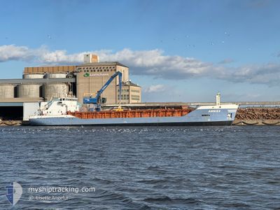
ANNIKA
General Cargo

Current Trip
| Time Travelled | 5 h, 52 mins |
|---|---|
| Remaining Time | 8 h, 26 mins |
| Distance Travelled | 48.46 nm |
| Remaining Distance | 75.71 nm |
| AVG Speed | 8.6 Knopen |
| MAX Speed | 8.9 Knopen |
| AVG Wind | 9.4 knots |
| MAX Wind | 15.2 knots |
| MIN Temp | 7.6°C / 45.68°F |
| MAX Temp | 8.8°C / 47.84°F |
| Diepgang | 5 M |
| Positie ontvangen | Nu |
Current Position
| Lengtegraad | 19.38020° |
|---|---|
| Breedtegraat | 60.51012° |
| Status | Under way using engine |
| Snelheid | 8.9 Knopen |
| Koers | 52.8° |
| Gebied | Gulf of Bothnia |
| Station | T-AIS |
| Positie ontvangen | Nu |
Information
The current position of ANNIKA is in Gulf of Bothnia with coordinates 60.51012° / 19.38020° as reported on 2025-05-28 19:14 by AIS to our vessel tracker app. The vessel's current speed is 8.9 Knopen and is heading at the port of RAUMA. The estimated time of arrival as calculated by MyShipTracking vessel tracking app is 2025-05-29 03:41 LT
The vessel ANNIKA (IMO: 9000833, MMSI: 230714000) is a General Cargo that was built in 1989 ( 36 Jaar oud ). It's sailing under the flag of [FI] Finland.
In this page you can find informations about the vessels current position, last detected port calls, and current voyage information. If the vessels is not in coverage by AIS you will find the latest position.
The current position of ANNIKA is detected by our AIS receivers and we are not responsible for the reliability of the data. The last position was recorded while the vessel was in Coverage by the Ais receivers of our vessel tracking app.
The current draught of ANNIKA as reported by AIS is 5 meters
Weather
| Temperature | 7.8°C / 46.04°F |
|---|---|
| Wind Speed | 8 knots |
| Direction | 159° SSE |
| Pressure | 1008.2 hPa |
| Humidity | 96.1 % |
| Cloud Coverage | 100 % |


Featured Company
Last Port Calls
| Port | Arrival | Departure | Time In Port |
|---|---|---|---|
| 2025-05-27 10:14 | 2025-05-28 13:23 | 1 d | |
| 2025-05-26 05:33 | 2025-05-26 16:09 | 10 h | |
| 2025-05-25 03:13 | |||
| 2025-05-22 12:21 | 2025-05-23 10:05 | 21 h | |
| 2025-05-19 22:10 | 2025-05-20 16:38 | 18 h | |
| 2025-05-18 04:47 | 2025-05-19 04:10 | 23 h | |
| 2025-05-16 04:29 | 2025-05-17 06:19 | 1 d | |
| 2025-05-14 14:14 | 2025-05-15 07:43 | 17 h | |
| 2025-05-11 06:54 | 2025-05-14 08:06 | 3 d | |
| 2025-05-05 20:44 | 2025-05-06 11:32 | 14 h |
Last Trips
| Origin | Departure | Destination | Arrival | Distance | |
|---|---|---|---|---|---|
| 2025-05-26 19:09 | 2025-05-27 13:14 | 172.82 nm | |||
| 2025-05-25 06:13 | 2025-05-26 08:33 | 218.25 nm | |||
| 2025-05-20 18:38 | 2025-05-22 15:21 | 390.82 nm | |||
| 2025-05-19 06:10 | 2025-05-20 00:10 | 162.58 nm | |||
| 2025-05-17 08:19 | 2025-05-18 06:47 | 178.63 nm | |||
| 2025-05-15 09:43 | 2025-05-16 06:29 | 177.48 nm | |||
| 2025-05-14 10:06 | 2025-05-14 16:14 | 60.49 nm | |||
| 2025-05-06 14:32 | 2025-05-11 08:54 | 553.99 nm | |||
| 2025-05-05 10:15 | 2025-05-05 23:44 | 123.74 nm | |||
| 2025-05-03 00:05 | 2025-05-04 00:42 | 103.57 nm |
Events
| Tijd | Evenement | Details | Positie / Bestemming | Info |
|---|---|---|---|---|
| 2025-05-28 18:14 | Wijzig zee gebeid | Finnish part of the Gulf of Bothnia Swedish part of the Gulf of Bothnia |
60.40910 / 19.16829
Gulf of Bothnia
FIRAU
|
Snelheid: 8.8 kn Koers: 28.4° |
| 2025-05-28 16:53 | ETA Changed | 2025/05/29 03:00 |
60.22117 / 19.09232
FIRAU
|
Snelheid: 8.7 kn Koers: 353.1° |
| 2025-05-28 16:53 | Wijzig zee gebeid | Swedish part of the Gulf of Bothnia Finnish part of the Gulf of Bothnia |
60.22077 / 19.09241
Gulf of Bothnia
|
Snelheid: 8.7 kn Koers: 353.2° |
| 2025-05-28 15:59 | ETA Changed | 2025/05/29 03:00 |
60.14404 / 19.29202
FIRAU
|
Snelheid: 8.7 kn Koers: 296.1° |
| 2025-05-28 13:59 | Draught Changed | 5 4.5 |
60.03626 / 19.83432
FIRAU
|
Snelheid: 8.7 kn Koers: 293.7° |
| 2025-05-28 13:23 | Vertrekhaven |
|
60.08583 / 19.92728
FIRAU
|
Snelheid: 7.3 kn Koers: 174° |
| 2025-05-28 13:12 | Start beweging |
60.10434 / 19.92227
[FI] MARIEHAMN
|
Snelheid: 4.1 kn Koers: 192° |
|
| 2025-05-28 12:58 | Destination Changed | FIRAU FIRMA |
60.10614 / 19.92405
[FI] MARIEHAMN
|
Snelheid: Koers: 11° |
| 2025-05-28 12:58 | ETA Changed | 2025/05/29 03:00 2025/05/28 22:00 |
60.10614 / 19.92405
[FI] MARIEHAMN
|
Snelheid: Koers: 11° |
| 2025-05-28 12:51 | Status Changed | Under way using engine Moored |
60.10615 / 19.92403
[FI] MARIEHAMN
|
Snelheid: Koers: 11° |