
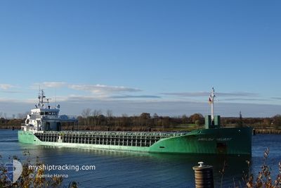
ARKLOW VALIANT
Cargo
Current Trip
| Time Travelled | 9 h, 58 mins |
|---|---|
| Remaining Time | 13 h, 41 mins |
| Distance Travelled | 105.46 nm |
| Remaining Distance | 163.20 nm |
| AVG Speed | 10.5 Knopen |
| MAX Speed | 12.4 Knopen |
| AVG Wind | 8.9 knots |
| MAX Wind | 13.8 knots |
| MIN Temp | 2.9°C / 37.22°F |
| MAX Temp | 4.9°C / 40.82°F |
| Diepgang | 5.9 M |
| Positie ontvangen | 2 m geleden |
Current Position
| Lengtegraad | 2.00335° |
|---|---|
| Breedtegraat | 52.93728° |
| Status | Under way using engine |
| Snelheid | 12.4 Knopen |
| Koers | 320.6° |
| Gebied | North Sea |
| Station | T-AIS |
| Positie ontvangen | 2 m geleden |
Info
Information
The current position of ARKLOW VALIANT is in North Sea with coordinates 52.93728° / 2.00335° as reported on 2025-02-12 00:01 by AIS to our vessel tracker app. The vessel's current speed is 12.4 Knopen and is heading at the port of MIDDLESBROUGH. The estimated time of arrival as calculated by MyShipTracking vessel tracking app is 2025-02-12 13:44 LT
The vessel ARKLOW VALIANT (IMO: 9772541, MMSI: 244710091) is a Cargo It's sailing under the flag of [NL] Netherlands.
In this page you can find informations about the vessels current position, last detected port calls, and current voyage information. If the vessels is not in coverage by AIS you will find the latest position.
The current position of ARKLOW VALIANT is detected by our AIS receivers and we are not responsible for the reliability of the data. The last position was recorded while the vessel was in Coverage by the Ais receivers of our vessel tracking app.
The current draught of ARKLOW VALIANT as reported by AIS is 5.9 meters
Weather
| Temperature | 4.9°C / 40.82°F |
|---|---|
| Wind Speed | 14 knots |
| Direction | 48° NE |
| Pressure | 1017.8 hPa |
| Humidity | 85.4 % |
| Cloud Coverage | 100 % |
Featured Company
Last Port Calls
| Port | Arrival | Departure | Time In Port |
|---|---|---|---|
| 2025-02-09 09:43 | 2025-02-11 14:05 | 2 d | |
| 2025-02-05 22:13 | 2025-02-06 21:52 | 23 h | |
| 2025-02-02 15:04 | 2025-02-04 13:57 | 1 d | |
| 2025-01-28 13:38 | 2025-01-30 06:33 | 1 d | |
| 2025-01-17 01:59 | 2025-01-20 16:11 | 3 d | |
| 2025-01-17 01:46 | 2025-01-17 01:54 | 8 m | |
| 2025-01-14 23:57 | 2025-01-15 00:56 | 59 m | |
| 2025-01-13 18:15 | 2025-01-14 23:24 | 1 d | |
| 2025-01-13 17:32 | 2025-01-13 17:48 | 15 m | |
| 2025-01-07 22:33 | 2025-01-09 00:37 | 1 d |
Last Trips
| Origin | Departure | Destination | Arrival | Distance | |
|---|---|---|---|---|---|
| 2025-02-06 21:52 | 2025-02-09 10:43 | 619.01 nm | |||
| 2025-02-04 13:57 | 2025-02-05 22:13 | 312.50 nm | |||
| 2025-01-30 07:33 | 2025-02-02 15:04 | 809.58 nm | |||
| 2025-01-20 16:11 | 2025-01-28 14:38 | 1093.79 nm | |||
| 2025-01-17 01:54 | 2025-01-17 01:59 | 0.70 nm | |||
| 2025-01-15 01:56 | 2025-01-17 01:46 | 545.85 nm | |||
| 2025-01-15 00:24 | 2025-01-15 00:57 | 2.30 nm | |||
| 2025-01-13 18:48 | 2025-01-13 19:15 | 1.21 nm | |||
| 2025-01-09 00:37 | 2025-01-13 18:32 | 584.17 nm | |||
| 2025-01-06 14:00 | 2025-01-07 22:33 | 305.83 nm |
Events
| Tijd | Evenement | Details | Positie / Bestemming | Info |
|---|---|---|---|---|
| 2025-02-11 23:16 | Wijzig zee gebeid | United Kingdom part of the North Sea Dutch part of the North Sea |
52.81478 / 2.13708
North Sea
GBMID
|
Snelheid: 11.1 kn Koers: 334.4° |
| 2025-02-11 23:15 | Status Changed | Under way using engine Default |
52.81297 / 2.13847
GBMID
|
Snelheid: 10.9 kn Koers: 333° |
| 2025-02-11 23:01 | Binnenbereik |
52.81478 / 2.13708
North Sea
GBMID
|
Snelheid: 11.1 kn Koers: 334.4° |
|
| 2025-02-11 17:16 | Status Changed | Default Under way using engine |
52.16717 / 3.48700
GBMID
|
Snelheid: 11.7 kn Koers: 306.5° |
| 2025-02-11 17:08 | Buitenbereik |
52.15298 / 3.51842
North Sea
GBMID
|
Snelheid: 11.7 kn Koers: 306.5° |
|
| 2025-02-11 17:07 | Status Changed | Under way using engine Default |
52.15168 / 3.52130
GBMID
|
Snelheid: 11.6 kn Koers: 300° |
| 2025-02-11 16:55 | Status Changed | Default Under way using engine |
52.12981 / 3.57885
GBMID
|
Snelheid: 11.6 kn Koers: 300.9° |
| 2025-02-11 14:05 | Vertrekhaven |
|
51.89642 / 4.29903
GBMID
|
Snelheid: 8.6 kn Koers: 292° |
| 2025-02-11 14:00 | Status Changed | Under way using engine Moored |
51.88778 / 4.30215
[NL] BOTLEK - ROTTERDAM
|
Snelheid: 7.7 kn Koers: 62° |
| 2025-02-11 13:51 | Start beweging |
51.88467 / 4.27833
[NL] BOTLEK - ROTTERDAM
|
Snelheid: 3.5 kn Koers: 96° |