
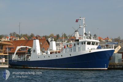
ARNE TISELIUS
Fishery Research Vessel
Current Trip
| Time Travelled | 4 days |
|---|---|
| Remaining Time | --- |
| Distance Travelled | 225.63 nm |
| Remaining Distance | --- |
| AVG Speed | 7.6 Knopen |
| MAX Speed | 9.7 Knopen |
| AVG Wind | 14.1 knots |
| MAX Wind | 21.7 knots |
| MIN Temp | 2°C / 35.6°F |
| MAX Temp | 5.7°C / 42.26°F |
| Diepgang | 3.6 M |
| Positie ontvangen | 3 d geleden |
Current Position
| Lengtegraad | 13.68877° |
|---|---|
| Breedtegraat | 54.52037° |
| Status | Under way using engine |
| Snelheid | 9 Knopen |
| Koers | 202.3° |
| Gebied | Baltic Sea |
| Station | T-AIS |
| Positie ontvangen | 3 d geleden |
Info
Information
The current position of ARNE TISELIUS is in Baltic Sea with coordinates 54.52037° / 13.68877° as reported on 2025-02-05 21:27 by AIS to our vessel tracker app. The vessel's current speed is 9 Knopen
The vessel ARNE TISELIUS (IMO: 7517624, MMSI: 219012162) is a Fishery Research Vessel that was built in 1976 ( 49 Jaar oud ). It's sailing under the flag of [DK] Denmark.
In this page you can find informations about the vessels current position, last detected port calls, and current voyage information. If the vessels is not in coverage by AIS you will find the latest position.
The current position of ARNE TISELIUS is detected by our AIS receivers and we are not responsible for the reliability of the data. The last position was recorded while the vessel was in Coverage by the Ais receivers of our vessel tracking app.
The current draught of ARNE TISELIUS as reported by AIS is 3.6 meters
Weather
| Temperature | 4.3°C / 39.74°F |
|---|---|
| Wind Speed | 12 knots |
| Direction | 285° WNW |
| Pressure | 1037.4 hPa |
| Humidity | 91.3 % |
| Cloud Coverage | 11 % |
Featured Company
Most Visited Ports (Last year)
| Port | Arrivals | |
|---|---|---|
| 24 | ||
| 4 | ||
| 2 |
Events
| Tijd | Evenement | Details | Positie / Bestemming | Info |
|---|---|---|---|---|
| 2025-02-05 21:27 | Buitenbereik |
54.52037 / 13.68877
Baltic Sea
DESAS
|
Snelheid: 9 kn Koers: 202.3° |
|
| 2025-02-05 21:01 | Binnenbereik |
54.58501 / 13.69287
Baltic Sea
DESAS
|
Snelheid: 9.2 kn Koers: 154.2° |
|
| 2025-02-05 18:03 | Buitenbereik |
54.97823 / 13.29022
Baltic Sea
DESAS
|
Snelheid: 9.2 kn Koers: 146.1° |
|
| 2025-02-05 17:50 | Wijzig zee gebeid | German part of the Baltic Sea Swedish part of the Baltic Sea |
55.00438 / 13.25846
Baltic Sea
DESAS
|
Snelheid: 9.2 kn Koers: 145.1° |
| 2025-02-05 16:47 | Destination Changed | DESAS SURVEY |
55.08816 / 13.01844
DESAS
|
Snelheid: 9.3 kn Koers: 115.8° |
| 2025-02-05 16:47 | ETA Changed | 2025/02/05 21:00 2025/02/05 10:00 |
55.08816 / 13.01844
DESAS
|
Snelheid: 9.3 kn Koers: 115.8° |
| 2025-02-05 16:35 | Wijzig zee gebeid | Swedish part of the Baltic Sea Danish part of the Baltic Sea |
55.10058 / 12.96896
Baltic Sea
|
Snelheid: 9.5 kn Koers: 95.9° |
| 2025-02-05 16:25 | Start beweging | 17.45 nm, South West of TRELLEBORG |
55.10448 / 12.92389
SURVEY
|
Snelheid: 6.7 kn Koers: 103.1° |
| 2025-02-05 16:18 | Stop beweging | 17.46 nm, South West of TRELLEBORG |
55.10527 / 12.92094
SURVEY
|
Snelheid: 0.3 kn Koers: 147° |
| 2025-02-05 15:42 | Start beweging | 15.99 nm, South East of STERN |
55.13858 / 12.79158
SURVEY
|
Snelheid: 9 kn Koers: 109.9° |