
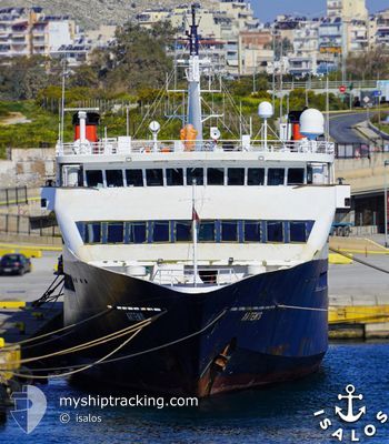
ARTEMIS
Ro-Ro/Passenger Ship
Current Trip
| Time Travelled | 4 mins |
|---|---|
| Remaining Time | 51 mins |
| Distance Travelled | 0.79 nm |
| Remaining Distance | 14.39 nm |
| AVG Speed | --- |
| MAX Speed | --- |
| AVG Wind | 1.8 knots |
| MAX Wind | 1.8 knots |
| MIN Temp | 15°C / 59°F |
| MAX Temp | 15°C / 59°F |
| Diepgang | 3.5 M |
| Positie ontvangen | Nu |
Current Position
| Lengtegraad | 24.59865° |
|---|---|
| Breedtegraat | 36.79387° |
| Status | Under way using engine |
| Snelheid | 14.5 Knopen |
| Koers | 29.8° |
| Gebied | Aegean Sea |
| Station | T-AIS |
| Positie ontvangen | Nu |
Info
Information
The current position of ARTEMIS is in Aegean Sea with coordinates 36.79387° / 24.59865° as reported on 2025-02-02 14:01 by AIS to our vessel tracker app. The vessel's current speed is 14.5 Knopen and is heading at the port of SIFNOS. The estimated time of arrival as calculated by MyShipTracking vessel tracking app is 2025-02-02 14:52 LT
The vessel ARTEMIS (IMO: 8966951, MMSI: 237026300) is a Ro-Ro/Passenger Ship that was built in 1997 ( 28 Jaar oud ). It's sailing under the flag of [GR] Greece.
In this page you can find informations about the vessels current position, last detected port calls, and current voyage information. If the vessels is not in coverage by AIS you will find the latest position.
The current position of ARTEMIS is detected by our AIS receivers and we are not responsible for the reliability of the data. The last position was recorded while the vessel was in Coverage by the Ais receivers of our vessel tracking app.
The current draught of ARTEMIS as reported by AIS is 3.5 meters
Weather
| Temperature | 15°C / 59°F |
|---|---|
| Wind Speed | 1 knots |
| Direction | 130° SE |
| Pressure | 1022.1 hPa |
| Humidity | 71.9 % |
| Cloud Coverage | --- |
Featured Company
Last Port Calls
| Port | Arrival | Departure | Time In Port |
|---|---|---|---|
| 2025-02-02 13:49 | 2025-02-02 13:57 | 8 m | |
| 2025-02-02 12:29 | 2025-02-02 12:48 | 18 m | |
| 2025-02-02 11:23 | 2025-02-02 11:33 | 10 m | |
| 2025-02-02 10:10 | 2025-02-02 10:27 | 17 m | |
| 2025-02-02 09:12 | 2025-02-02 09:27 | 14 m | |
| 2025-02-02 06:39 | 2025-02-02 07:11 | 31 m | |
| 2025-02-01 16:50 | 2025-02-02 05:07 | 12 h | |
| 2025-02-01 14:56 | 2025-02-01 15:16 | 20 m | |
| 2025-02-01 13:22 | 2025-02-01 13:50 | 27 m | |
| 2025-02-01 11:16 | 2025-02-01 11:35 | 19 m |
Last Trips
| Origin | Departure | Destination | Arrival | Distance | |
|---|---|---|---|---|---|
| 2025-02-02 14:48 | 2025-02-02 15:49 | 14.10 nm | |||
| 2025-02-02 13:33 | 2025-02-02 14:29 | 13.99 nm | |||
| 2025-02-02 12:27 | 2025-02-02 13:23 | 13.49 nm | |||
| 2025-02-02 11:27 | 2025-02-02 12:10 | 10.21 nm | |||
| 2025-02-02 09:11 | 2025-02-02 11:12 | 29.68 nm | |||
| 2025-02-02 07:07 | 2025-02-02 08:39 | 23.48 nm | |||
| 2025-02-01 17:16 | 2025-02-01 18:50 | 23.13 nm | |||
| 2025-02-01 15:50 | 2025-02-01 16:56 | 16.20 nm | |||
| 2025-02-01 13:35 | 2025-02-01 15:22 | 26.62 nm | |||
| 2025-02-01 12:51 | 2025-02-01 13:16 | 6.57 nm |
Events
| Tijd | Evenement | Details | Positie / Bestemming | Info |
|---|---|---|---|---|
| 2025-02-02 13:57 | Vertrekhaven |
|
36.78457 / 24.58530
PSSKMKSSPS
|
Snelheid: 10.4 kn Koers: 79° |
| 2025-02-02 13:57 | Start beweging |
36.78425 / 24.58403
[GR] KIMOLOS
|
Snelheid: 10.4 kn Koers: 79° |
|
| 2025-02-02 13:49 | Aankomsthaven |
|
36.78409 / 24.58137
[GR] KIMOLOS
|
Snelheid: 3.6 kn Koers: 154° |
| 2025-02-02 13:48 | Stop beweging | 0.11 nm, South East of KIMOLOS |
36.78360 / 24.58186
PSSKMKSSPS
|
Snelheid: 0.2 kn Koers: 136° |
| 2025-02-02 12:48 | Vertrekhaven |
|
36.71744 / 24.43953
PSSKMKSSPS
|
Snelheid: 13.2 kn Koers: 233° |
| 2025-02-02 12:47 | Start beweging |
36.72035 / 24.44352
[GR] MILOS
|
Snelheid: 10.2 kn Koers: 221° |
|
| 2025-02-02 12:32 | Stop beweging |
36.72204 / 24.44495
[GR] MILOS
|
Snelheid: 0.3 kn Koers: 172° |
|
| 2025-02-02 12:29 | Aankomsthaven |
|
36.71923 / 24.43932
[GR] MILOS
|
Snelheid: 12.1 kn Koers: 43.8° |
| 2025-02-02 11:33 | Start beweging | 0.19 nm, South of KIMOLOS |
36.78177 / 24.58127
PSSKMKSSPS
|
Snelheid: 10.2 kn Koers: 179° |
| 2025-02-02 11:33 | Vertrekhaven |
|
36.78177 / 24.58127
PSSKMKSSPS
|
Snelheid: 9.3 kn Koers: 171° |