
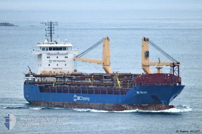
BBC BELEM
General Cargo
Current Trip
| Time Travelled | 4 days |
|---|---|
| Remaining Time | 1 h, 11 mins |
| Distance Travelled | 248.08 nm |
| Remaining Distance | 11.22 nm |
| AVG Speed | 8.4 Knopen |
| MAX Speed | 11.2 Knopen |
| AVG Wind | 11.3 knots |
| MAX Wind | 21.6 knots |
| MIN Temp | 7.6°C / 45.68°F |
| MAX Temp | 13.6°C / 56.48°F |
| Diepgang | 4.8 M |
| Positie ontvangen | 1 m geleden |
Current Position
| Lengtegraad | 8.96095° |
|---|---|
| Breedtegraat | 44.23292° |
| Status | Under way using engine |
| Snelheid | 8.3 Knopen |
| Koers | 6.9° |
| Gebied | Ligurian Sea |
| Station | T-AIS |
| Positie ontvangen | 1 m geleden |
Info
Information
The current position of BBC BELEM is in Ligurian Sea with coordinates 44.23292° / 8.96095° as reported on 2025-02-08 00:45 by AIS to our vessel tracker app. The vessel's current speed is 8.3 Knopen and is heading at the port of GENOVA. The estimated time of arrival as calculated by MyShipTracking vessel tracking app is 2025-02-08 02:57 LT
The vessel BBC BELEM (IMO: 9501655, MMSI: 305729000) is a General Cargo that was built in 2012 ( 13 Jaar oud ). It's sailing under the flag of [AG] Antigua Barbuda.
In this page you can find informations about the vessels current position, last detected port calls, and current voyage information. If the vessels is not in coverage by AIS you will find the latest position.
The current position of BBC BELEM is detected by our AIS receivers and we are not responsible for the reliability of the data. The last position was recorded while the vessel was in Coverage by the Ais receivers of our vessel tracking app.
The current draught of BBC BELEM as reported by AIS is 4.8 meters
Weather
| Temperature | 7.8°C / 46.04°F |
|---|---|
| Wind Speed | 18 knots |
| Direction | 346° NNW |
| Pressure | 1027.3 hPa |
| Humidity | 85.8 % |
| Cloud Coverage | 100 % |
Featured Company
Last Port Calls
| Port | Arrival | Departure | Time In Port |
|---|---|---|---|
| 2025-01-31 18:38 | 2025-02-03 19:50 | 3 d | |
| 2025-01-26 00:51 | 2025-01-27 00:10 | 23 h | |
| 2025-01-10 11:16 | 2025-01-12 01:56 | 1 d | |
| 2024-12-23 21:06 | 2024-12-25 10:38 | 1 d | |
| 2024-12-07 12:45 | 2024-12-10 02:19 | 2 d | |
| 2024-12-03 07:03 | 2024-12-06 18:25 | 3 d | |
| 2024-12-02 07:09 |
Last Trips
| Origin | Departure | Destination | Arrival | Distance | |
|---|---|---|---|---|---|
| 2025-01-27 00:10 | 2025-01-31 18:38 | 1114.74 nm | |||
| 2025-01-12 01:56 | 2025-01-26 00:51 | 316.22 nm | |||
| 2024-12-25 10:38 | 2025-01-10 11:16 | 1663.20 nm | |||
| 2024-12-10 02:19 | 2024-12-23 21:06 | 3081.78 nm | |||
| 2024-12-06 18:25 | 2024-12-07 12:45 | 161.01 nm | |||
| 2024-12-02 07:09 | 2024-12-03 07:03 | 184.08 nm |
Events
| Tijd | Evenement | Details | Positie / Bestemming | Info |
|---|---|---|---|---|
| 2025-02-08 00:19 | Status Changed | Under way using engine Default |
44.17292 / 8.94982
ITGOA
|
Snelheid: 8.3 kn Koers: 10° |
| 2025-02-08 00:13 | Status Changed | Default Under way using engine |
44.15962 / 8.94684
ITGOA
|
Snelheid: 8.3 kn Koers: 8.3° |
| 2025-02-08 00:13 | Status Changed | Under way using engine Default |
44.15848 / 8.94657
ITGOA
|
Snelheid: 8.3 kn Koers: 9° |
| 2025-02-08 00:09 | Status Changed | Default Under way using engine |
44.15001 / 8.94474
ITGOA
|
Snelheid: 8.3 kn Koers: 8.3° |
| 2025-02-07 23:48 | Destination Changed | ITGOA FOR ORD |
44.09969 / 8.93259
ITGOA
|
Snelheid: 8.3 kn Koers: 9° |
| 2025-02-07 23:48 | ETA Changed | 2025/02/08 02:00 2025/02/10 12:00 |
44.09969 / 8.93259
ITGOA
|
Snelheid: 8.3 kn Koers: 9° |
| 2025-02-07 23:44 | Status Changed | Under way using engine Default |
44.09257 / 8.93098
FOR ORD
|
Snelheid: 8.1 kn Koers: 9° |
| 2025-02-07 23:41 | Status Changed | Default Under way using engine |
44.08666 / 8.92962
FOR ORD
|
Snelheid: 8 kn Koers: 7.1° |
| 2025-02-07 23:31 | Gevonden in zee | Italian part of the Ligurian Sea |
44.06461 / 8.92502
Ligurian Sea
FOR ORD
|
Snelheid: 8 kn Koers: 7.1° |
| 2025-02-07 23:31 | Status Changed | Under way using engine Default |
44.06349 / 8.92483
FOR ORD
|
Snelheid: 8 kn Koers: 8° |