
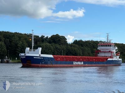
BENABELL G
Cargo
Current Trip
| Time Travelled | 17 h, 34 mins |
|---|---|
| Remaining Time | 18 h, 49 mins |
| Distance Travelled | 41.85 nm |
| Remaining Distance | 321.10 nm |
| AVG Speed | 8.5 Knopen |
| MAX Speed | 11.7 Knopen |
| AVG Wind | 14.8 knots |
| MAX Wind | 24.8 knots |
| MIN Temp | 3°C / 37.4°F |
| MAX Temp | 5.3°C / 41.54°F |
| Diepgang | 5.4 M |
| Positie ontvangen | 12 h, 48 m geleden |
Current Position
| Lengtegraad | 8.23242° |
|---|---|
| Breedtegraat | 54.02713° |
| Status | Under way using engine |
| Snelheid | 9.8 Knopen |
| Koers | 322° |
| Gebied | North Sea |
| Station | T-AIS |
| Positie ontvangen | 12 h, 48 m geleden |
Info
Information
The current position of BENABELL G is in North Sea with coordinates 54.02713° / 8.23242° as reported on 2025-02-09 16:27 by AIS to our vessel tracker app. The vessel's current speed is 9.8 Knopen and is heading at the port of SHEERNESS. The estimated time of arrival as calculated by MyShipTracking vessel tracking app is 2025-02-11 00:04 LT
The vessel BENABELL G (IMO: 9864772, MMSI: 305919000) is a Cargo It's sailing under the flag of [AG] Antigua Barbuda.
In this page you can find informations about the vessels current position, last detected port calls, and current voyage information. If the vessels is not in coverage by AIS you will find the latest position.
The current position of BENABELL G is detected by our AIS receivers and we are not responsible for the reliability of the data. The last position was recorded while the vessel was in Coverage by the Ais receivers of our vessel tracking app.
The current draught of BENABELL G as reported by AIS is 5.4 meters
Weather
| Temperature | 3°C / 37.4°F |
|---|---|
| Wind Speed | 24 knots |
| Direction | 72° ENE |
| Pressure | 1032.2 hPa |
| Humidity | 86.6 % |
| Cloud Coverage | 100 % |
Featured Company
Last Port Calls
| Port | Arrival | Departure | Time In Port |
|---|---|---|---|
| 2025-02-09 11:33 | 2025-02-09 12:41 | 1 h | |
| 2025-02-06 10:12 | 2025-02-07 16:09 | 1 d | |
| 2025-02-04 06:40 | 2025-02-04 23:02 | 16 h | |
| 2025-01-31 21:03 | 2025-02-01 20:42 | 23 h | |
| 2025-01-24 02:11 | 2025-01-24 03:35 | 1 h | |
| 2025-01-19 09:14 | 2025-01-20 22:28 | 1 d | |
| 2025-01-16 19:58 | 2025-01-17 19:14 | 23 h | |
| 2025-01-12 04:06 | 2025-01-12 07:09 | 3 h | |
| 2025-01-07 07:21 | 2025-01-08 19:05 | 1 d | |
| 2025-01-06 06:52 | 2025-01-06 21:37 | 14 h |
Most Visited Ports (Last year)
| Port | Arrivals | |
|---|---|---|
| 8 | ||
| 5 | ||
| 5 | ||
| 5 | ||
| 3 | ||
| 3 |
Last Trips
| Origin | Departure | Destination | Arrival | Distance | |
|---|---|---|---|---|---|
| 2025-02-07 16:09 | 2025-02-09 11:33 | 381.53 nm | |||
| 2025-02-04 23:02 | 2025-02-06 10:12 | 329.42 nm | |||
| 2025-02-01 20:42 | 2025-02-04 06:40 | 439.61 nm | |||
| 2025-01-24 03:35 | 2025-01-31 21:03 | 591.39 nm | |||
| 2025-01-20 22:28 | 2025-01-24 02:11 | 242.34 nm | |||
| 2025-01-17 19:14 | 2025-01-19 09:14 | 250.01 nm | |||
| 2025-01-12 07:09 | 2025-01-16 19:58 | 480.21 nm | |||
| 2025-01-08 19:05 | 2025-01-12 04:06 | 777.09 nm | |||
| 2025-01-06 21:37 | 2025-01-07 07:21 | 97.53 nm | |||
| 2025-01-04 08:20 | 2025-01-06 06:52 | 447.06 nm |
Events
| Tijd | Evenement | Details | Positie / Bestemming | Info |
|---|---|---|---|---|
| 2025-02-09 17:16 | Stop beweging | 11.39 nm, South East of HELGOLAND |
54.07003 / 8.16704
GBSHS
|
Snelheid: 0.2 kn Koers: 107° |
| 2025-02-09 16:32 | Status Changed | Default Under way using engine |
54.03986 / 8.21832
GBSHS
|
Snelheid: 9.8 kn Koers: 322° |
| 2025-02-09 16:27 | Buitenbereik |
54.02713 / 8.23242
North Sea
GBSHS
|
Snelheid: 9.8 kn Koers: 322° |
|
| 2025-02-09 16:19 | Status Changed | Under way using engine Default |
54.01621 / 8.26108
GBSHS
|
Snelheid: 10.2 kn Koers: 286° |
| 2025-02-09 15:41 | Status Changed | Default Under way using engine |
53.98728 / 8.43024
GBSHS
|
Snelheid: 9.5 kn Koers: 285.6° |
| 2025-02-09 15:41 | Status Changed | Under way using engine Default |
53.98704 / 8.43159
GBSHS
|
Snelheid: 9.9 kn Koers: 286° |
| 2025-02-09 15:37 | Status Changed | Default Under way using engine |
53.98461 / 8.44709
GBSHS
|
Snelheid: 10.7 kn Koers: 283.9° |
| 2025-02-09 15:24 | Status Changed | Under way using engine Default |
53.97564 / 8.51081
GBSHS
|
Snelheid: 11.2 kn Koers: 281° |
| 2025-02-09 15:21 | Status Changed | Default Under way using engine |
53.97385 / 8.52643
GBSHS
|
Snelheid: 11.2 kn Koers: 280.4° |
| 2025-02-09 14:31 | Start beweging | 1.05 nm, North of CUXHAVEN |
53.88486 / 8.71226
GBSHS
|
Snelheid: 6.8 kn Koers: 297° |