
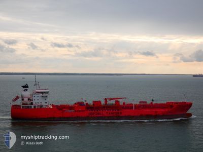
BOW TUNGSTEN
Tanker
Current Trip
| Time Travelled | 15 days |
|---|---|
| Remaining Time | --- |
| Distance Travelled | 4297.44 nm |
| Remaining Distance | --- |
| AVG Speed | 13.3 Knopen |
| MAX Speed | 15.7 Knopen |
| AVG Wind | 13 knots |
| MAX Wind | 29 knots |
| MIN Temp | 16.4°C / 61.52°F |
| MAX Temp | 28.9°C / 84.02°F |
| Diepgang | 7.4 M |
| Positie ontvangen | 3 d geleden |
Current Position
| Lengtegraad | -45.97614° |
|---|---|
| Breedtegraat | -27.22650° |
| Status | Under way using engine |
| Snelheid | 13.2 Knopen |
| Koers | 42.7° |
| Gebied | South Atlantic Ocean |
| Station | T-AIS |
| Positie ontvangen | 3 d geleden |
Info
Information
The current position of BOW TUNGSTEN is in South Atlantic Ocean with coordinates -27.22650° / -45.97614° as reported on 2025-02-12 05:18 by AIS to our vessel tracker app. The vessel's current speed is 13.2 Knopen
The vessel BOW TUNGSTEN (IMO: 9777400, MMSI: 257290000) is a Tanker It's sailing under the flag of [NO] Norway.
In this page you can find informations about the vessels current position, last detected port calls, and current voyage information. If the vessels is not in coverage by AIS you will find the latest position.
The current position of BOW TUNGSTEN is detected by our AIS receivers and we are not responsible for the reliability of the data. The last position was recorded while the vessel was in Coverage by the Ais receivers of our vessel tracking app.
The current draught of BOW TUNGSTEN as reported by AIS is 7.4 meters
Weather
| Temperature | 27.8°C / 82.04°F |
|---|---|
| Wind Speed | 15 knots |
| Direction | 106° ESE |
| Pressure | 1010.9 hPa |
| Humidity | 72.2 % |
| Cloud Coverage | 6 % |
Featured Company
Last Port Calls
| Port | Arrival | Departure | Time In Port |
|---|---|---|---|
| 2025-01-29 17:24 | 2025-01-31 14:49 | 1 d | |
| 2025-01-20 20:09 | 2025-01-23 14:30 | 2 d | |
| 2024-12-27 17:06 | 2024-12-28 19:42 | 1 d | |
| 2024-12-22 00:04 | 2024-12-24 02:49 | 2 d | |
| 2024-12-17 10:30 | 2024-12-19 04:14 | 1 d | |
| 2024-12-12 16:07 | 2024-12-14 03:41 | 1 d | |
| 2024-12-07 16:05 | 2024-12-09 16:41 | 2 d | |
| 2024-12-01 08:32 | 2024-12-03 06:58 | 1 d |
Last Trips
| Origin | Departure | Destination | Arrival | Distance | |
|---|---|---|---|---|---|
| 2025-01-23 14:30 | 2025-01-29 17:24 | 412.93 nm | |||
| 2024-12-28 19:42 | 2025-01-20 20:09 | 4008.94 nm | |||
| 2024-12-24 02:49 | 2024-12-27 17:06 | 980.67 nm | |||
| 2024-12-19 04:14 | 2024-12-22 00:04 | 984.04 nm | |||
| 2024-12-14 03:41 | 2024-12-17 10:30 | 994.71 nm | |||
| 2024-12-09 16:41 | 2024-12-12 16:07 | 981.12 nm | |||
| 2024-12-03 06:58 | 2024-12-07 16:05 | 987.51 nm | |||
| 2024-11-28 05:27 | 2024-12-01 08:32 | 1017.82 nm |
Events
| Tijd | Evenement | Details | Positie / Bestemming | Info |
|---|---|---|---|---|
| 2025-02-15 17:13 | Stop beweging | 2.42 nm, North West of SALVADOR |
-12.93369 / -38.53672
BR RIG>BR ARB
|
Snelheid: 0.2 kn Koers: 141° |
| 2025-02-12 05:22 | Status Changed | Default Under way using engine |
-27.21511 / -45.96435
BR RIG>BR ARB
|
Snelheid: 13.2 kn Koers: 42.7° |
| 2025-02-12 05:18 | Buitenbereik |
-27.22650 / -45.97614
South Atlantic Ocean
BR RIG>BR ARB
|
Snelheid: 13.2 kn Koers: 42.7° |
|
| 2025-02-12 04:59 | Status Changed | Under way using engine Default |
-27.27771 / -46.03087
BR RIG>BR ARB
|
Snelheid: 12.9 kn Koers: 45° |
| 2025-02-12 04:28 | Status Changed | Default Under way using engine |
-27.35177 / -46.12136
BR RIG>BR ARB
|
Snelheid: 12.8 kn Koers: 55° |
| 2025-02-12 04:03 | Status Changed | Under way using engine Default |
-27.40476 / -46.20272
BR RIG>BR ARB
|
Snelheid: 12.9 kn Koers: 54° |
| 2025-02-12 04:02 | Binnenbereik |
-27.40231 / -46.19900
South Atlantic Ocean
BR RIG>BR ARB
|
Snelheid: 12.9 kn Koers: 53.4° |
|
| 2025-02-12 02:14 | Status Changed | Default Under way using engine |
-27.64842 / -46.55071
BR RIG>BR ARB
|
Snelheid: 12.9 kn Koers: 47.5° |
| 2025-02-12 02:08 | Buitenbereik |
-27.66256 / -46.56818
South Atlantic Ocean
BR RIG>BR ARB
|
Snelheid: 12.9 kn Koers: 47.5° |
|
| 2025-02-12 02:08 | Status Changed | Under way using engine Default |
-27.66328 / -46.56909
BR RIG>BR ARB
|
Snelheid: 12.9 kn Koers: 47° |