
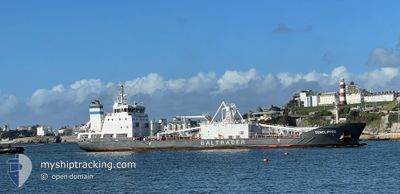
CEMCLIPPER
Cargo
Current Trip
| Trip Time | 2 days |
|---|---|
| Trip Distance | 704.15 nm |
| AVG Speed | 10.2 Knopen |
| MAX Speed | 12.7 Knopen |
| Diepgang | 4.7 M |
| AVG Wind | 14.4 knots |
| MAX Wind | 26.8 knots |
| MIN Temp | 7.4°C / 45.32°F |
| MAX Temp | 10.6°C / 51.08°F |
| Positie ontvangen | 1 m geleden |
Current Position
| Lengtegraad | -3.81473° |
|---|---|
| Breedtegraat | 43.44211° |
| Status | Moored |
| Snelheid | 0.2 Knopen |
| Koers | 277° |
| Gebied | Bay of Biscay |
| Station | T-AIS |
| Positie ontvangen | 1 m geleden |
Info
Information
The current position of CEMCLIPPER is in Bay of Biscay with coordinates 43.44211° / -3.81473° as reported on 2025-02-08 04:57 by AIS to our vessel tracker app. The vessel's current speed is 0.2 Knopen and is currently inside the port of SANTANDER.
The vessel CEMCLIPPER (IMO: 9884667, MMSI: 209133000) is a Cargo It's sailing under the flag of [CY] Cyprus.
In this page you can find informations about the vessels current position, last detected port calls, and current voyage information. If the vessels is not in coverage by AIS you will find the latest position.
The current position of CEMCLIPPER is detected by our AIS receivers and we are not responsible for the reliability of the data. The last position was recorded while the vessel was in Coverage by the Ais receivers of our vessel tracking app.
The current draught of CEMCLIPPER as reported by AIS is 5.7 meters
Weather
| Temperature | 8°C / 46.4°F |
|---|---|
| Wind Speed | 12 knots |
| Direction | 250° WSW |
| Pressure | 1020.4 hPa |
| Humidity | 70 % |
| Cloud Coverage | 94 % |
Featured Company
Last Port Calls
| Port | Arrival | Departure | Time In Port |
|---|---|---|---|
| 2025-02-07 08:14 | |||
| 2025-02-04 12:36 | 2025-02-04 13:10 | 34 m | |
| 2025-02-04 11:51 | 2025-02-04 12:16 | 24 m | |
| 2025-02-02 04:36 | 2025-02-04 11:11 | 2 d | |
| 2025-02-02 03:30 | 2025-02-02 03:49 | 19 m | |
| 2025-02-02 02:14 | 2025-02-02 03:08 | 53 m | |
| 2025-02-01 14:17 | 2025-02-01 23:12 | 8 h | |
| 2025-01-28 06:35 | 2025-01-29 18:40 | 1 d | |
| 2025-01-25 22:15 | 2025-01-27 11:22 | 1 d | |
| 2025-01-22 23:55 | 2025-01-23 17:15 | 17 h |
Last Trips
| Origin | Departure | Destination | Arrival | Distance | |
|---|---|---|---|---|---|
| 2025-02-04 13:10 | 2025-02-07 09:14 | 704.15 nm | |||
| 2025-02-04 12:16 | 2025-02-04 12:36 | 1.92 nm | |||
| 2025-02-04 11:11 | 2025-02-04 11:51 | 4.31 nm | |||
| 2025-02-02 03:49 | 2025-02-02 04:36 | 4.14 nm | |||
| 2025-02-02 03:08 | 2025-02-02 03:30 | 1.44 nm | |||
| 2025-01-29 19:40 | 2025-02-02 02:14 | 738.71 nm | |||
| 2025-01-29 19:40 | 2025-02-01 14:17 | 712.95 nm | |||
| 2025-01-27 11:22 | 2025-01-28 07:35 | 184.18 nm | |||
| 2025-01-23 18:15 | 2025-01-25 22:15 | 392.30 nm | |||
| 2025-01-21 07:39 | 2025-01-23 00:55 | 388.74 nm |
Events
| Tijd | Evenement | Details | Positie / Bestemming | Info |
|---|---|---|---|---|
| 2025-02-07 12:39 | Draught Changed | 5.7 4.7 |
43.44213 / -3.81471
[ES] SANTANDER
|
Snelheid: Koers: 277° |
| 2025-02-07 12:39 | Destination Changed | GBPLY ESSDR |
43.44213 / -3.81471
[ES] SANTANDER
|
Snelheid: Koers: 277° |
| 2025-02-07 12:39 | ETA Changed | 2025/02/10 12:00 2025/02/07 07:00 |
43.44213 / -3.81471
[ES] SANTANDER
|
Snelheid: Koers: 277° |
| 2025-02-07 08:36 | Status Changed | Moored Under way using engine |
43.44218 / -3.81474
[ES] SANTANDER
|
Snelheid: Koers: 276° |
| 2025-02-07 08:32 | Stop beweging |
43.44219 / -3.81467
[ES] SANTANDER
|
Snelheid: 0.3 kn Koers: 273° |
|
| 2025-02-07 08:14 | Aankomsthaven |
|
43.45775 / -3.79279
[ES] SANTANDER
|
Snelheid: 11.2 kn Koers: 261.3° |
| 2025-02-07 07:10 | Draught Changed | 4.7 4.8 |
43.59933 / -3.79285
ESSDR
|
Snelheid: 9.2 kn Koers: 158.1° |
| 2025-02-07 06:56 | Status Changed | Under way using engine Default |
43.63225 / -3.81055
ESSDR
|
Snelheid: 9 kn Koers: 160° |
| 2025-02-07 06:51 | Status Changed | Default Under way using engine |
43.64464 / -3.81641
ESSDR
|
Snelheid: 9.1 kn Koers: 162.4° |
| 2025-02-07 06:40 | Wijzig zee gebeid | Spanish part of the Bay of Biscay United Kingdom part of the Irish Sea and St. George's Channel |
43.67182 / -3.82832
Bay of Biscay
ESSDR
|
Snelheid: 9.1 kn Koers: 161.9° |