
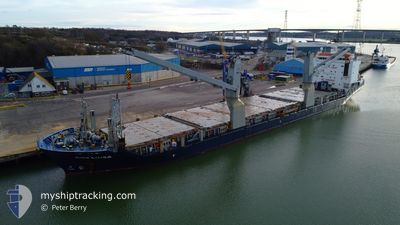
COE LUISA
General Cargo
Current Trip
USPAB
| Time Travelled | 1 day |
|---|---|
| Remaining Time | --- |
| Distance Travelled | 271.51 nm |
| Remaining Distance | --- |
| AVG Speed | 11.8 Knopen |
| MAX Speed | 15.1 Knopen |
| AVG Wind | 23.7 knots |
| MAX Wind | 31 knots |
| MIN Temp | 16.5°C / 61.7°F |
| MAX Temp | 21.7°C / 71.06°F |
| Diepgang | 6.2 M |
| Positie ontvangen | 1 d geleden |
Current Position
| Lengtegraad | -79.88314° |
|---|---|
| Breedtegraat | 26.91484° |
| Status | Under way using engine |
| Snelheid | 14.9 Knopen |
| Koers | 27.1° |
| Gebied | North Atlantic Ocean |
| Station | T-AIS |
| Positie ontvangen | 1 d geleden |
Info
Information
The current position of COE LUISA is in North Atlantic Ocean with coordinates 26.91484° / -79.88314° as reported on 2025-03-11 01:15 by AIS to our vessel tracker app. The vessel's current speed is 14.9 Knopen
The vessel COE LUISA (IMO: 9435026, MMSI: 305172000) is a General Cargo that was built in 2008 ( 17 Jaar oud ). It's sailing under the flag of [AG] Antigua Barbuda.
In this page you can find informations about the vessels current position, last detected port calls, and current voyage information. If the vessels is not in coverage by AIS you will find the latest position.
The current position of COE LUISA is detected by our AIS receivers and we are not responsible for the reliability of the data. The last position was recorded while the vessel was in Coverage by the Ais receivers of our vessel tracking app.
The current draught of COE LUISA as reported by AIS is 6.2 meters
Weather
| Temperature | 21.3°C / 70.34°F |
|---|---|
| Wind Speed | 11 knots |
| Direction | 309° NW |
| Pressure | 1015.2 hPa |
| Humidity | 45.5 % |
| Cloud Coverage | --- |
Featured Company
Last Port Calls
| Port | Arrival | Departure | Time In Port |
|---|---|---|---|
| 2025-03-09 11:25 | 2025-03-11 00:11 | 1 d | |
| 2025-02-13 17:55 | 2025-02-20 23:08 | 7 d | |
| 2025-02-11 18:43 | 2025-02-13 11:39 | 1 d | |
| 2025-02-07 15:13 | 2025-02-09 09:07 | 1 d | |
| 2025-01-20 20:05 | 2025-01-22 17:34 | 1 d | |
| 2025-01-14 15:33 | 2025-01-16 18:25 | 2 d | |
| 2025-01-07 12:13 | 2025-01-10 00:20 | 2 d |
Most Visited Ports (Last year)
| Port | Arrivals | |
|---|---|---|
| 4 | ||
| 3 | ||
| 3 | ||
| 3 | ||
| 2 | ||
| 2 |
Last Trips
| Origin | Departure | Destination | Arrival | Distance | |
|---|---|---|---|---|---|
| 2025-02-21 00:08 | 2025-03-09 07:25 | 4944.43 nm | |||
| 2025-02-13 12:39 | 2025-02-13 18:55 | 84.46 nm | |||
| 2025-02-09 11:07 | 2025-02-11 19:43 | 737.72 nm | |||
| 2025-01-22 18:34 | 2025-02-07 17:13 | 3233.68 nm | |||
| 2025-01-16 19:25 | 2025-01-20 21:05 | 1135.87 nm | |||
| 2025-01-10 02:20 | 2025-01-14 16:33 | 288.53 nm | |||
| 2024-12-24 13:22 | 2025-01-07 14:13 | 1280.96 nm |
Events
| Tijd | Evenement | Details | Positie / Bestemming | Info |
|---|---|---|---|---|
| 2025-03-11 01:21 | Status Changed | Default Under way using engine |
26.94008 / -79.86868
USPAB
|
Snelheid: 14.9 kn Koers: 27.1° |
| 2025-03-11 01:15 | Buitenbereik |
26.91484 / -79.88314
North Atlantic Ocean
|
Snelheid: 14.9 kn Koers: 27.1° |
|
| 2025-03-11 00:53 | Status Changed | Under way using engine Default |
26.84040 / -79.93823
USPAB
|
Snelheid: 14.6 kn Koers: 29° |
| 2025-03-11 00:53 | Binnenbereik |
26.84614 / -79.93375
North Atlantic Ocean
|
Snelheid: 14.5 kn Koers: 36° |
|
| 2025-03-11 00:21 | Start beweging | 1 nm, East of PALM BEACH |
26.77212 / -80.02320
USPAB
|
Snelheid: 8.9 kn Koers: 79° |
| 2025-03-11 00:11 | Vertrekhaven |
|
26.77212 / -80.02320
USPAB
|
Snelheid: 1.2 kn Koers: 265° |
| 2025-03-10 12:50 | Status Changed | Default Moored |
26.76673 / -80.05109
[US] PALM BEACH
|
Snelheid: Koers: 264° |
| 2025-03-10 12:26 | Buitenbereik |
26.76667 / -80.05114
North Atlantic Ocean
[US] PALM BEACH
|
Snelheid: Koers: 282.7° |
|
| 2025-03-10 11:56 | Status Changed | Moored Default |
26.76674 / -80.05112
[US] PALM BEACH
|
Snelheid: Koers: 264° |
| 2025-03-10 11:26 | Status Changed | Default Moored |
26.76668 / -80.05112
[US] PALM BEACH
|
Snelheid: Koers: 264° |