
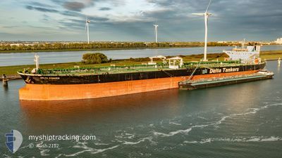
DELTA KANARIS
Crude Oil Tanker
Current Trip
| Time Travelled | --- |
|---|---|
| Remaining Time | --- |
| Distance Travelled | 8910.57 nm |
| Remaining Distance | --- |
| AVG Speed | 11 Knopen |
| MAX Speed | 15.4 Knopen |
| AVG Wind | 12.2 knots |
| MAX Wind | 35 knots |
| MIN Temp | 10.3°C / 50.54°F |
| MAX Temp | 29.2°C / 84.56°F |
| Diepgang | 16.6 M |
| Positie ontvangen | 3 m geleden |
Current Position
| Lengtegraad | -5.53250° |
|---|---|
| Breedtegraat | 35.98372° |
| Status | Under way using engine |
| Snelheid | 10.2 Knopen |
| Koers | 252° |
| Gebied | Strait of Gibraltar |
| Station | T-AIS |
| Positie ontvangen | 3 m geleden |
Info
Information
The current position of DELTA KANARIS is in Strait of Gibraltar with coordinates 35.98372° / -5.53250° as reported on 2025-02-12 12:09 by AIS to our vessel tracker app. The vessel's current speed is 10.2 Knopen and is heading at the port of PEMBROKE. The estimated time of arrival as calculated by MyShipTracking vessel tracking app is 2025-02-16 11:00 LT
The vessel DELTA KANARIS (IMO: 9429015, MMSI: 636020072) is a Crude Oil Tanker that was built in 2010 ( 15 Jaar oud ). It's sailing under the flag of [LR] Liberia.
In this page you can find informations about the vessels current position, last detected port calls, and current voyage information. If the vessels is not in coverage by AIS you will find the latest position.
The current position of DELTA KANARIS is detected by our AIS receivers and we are not responsible for the reliability of the data. The last position was recorded while the vessel was in Coverage by the Ais receivers of our vessel tracking app.
The current draught of DELTA KANARIS as reported by AIS is 16.6 meters
Weather
| Temperature | 15°C / 59°F |
|---|---|
| Wind Speed | 12 knots |
| Direction | 280° W |
| Pressure | 1021.9 hPa |
| Humidity | 67.8 % |
| Cloud Coverage | 60 % |
Featured Company
Last Port Calls
Most Visited Ports (Last year)
| Port | Arrivals | |
|---|---|---|
| 3 | ||
| 2 | ||
| 1 | ||
| 1 | ||
| 1 | ||
| 1 |
Last Trips
| Origin | Departure | Destination | Arrival | Distance |
|---|
Events
| Tijd | Evenement | Details | Positie / Bestemming | Info |
|---|---|---|---|---|
| 2025-02-12 10:59 | Wijzig zee gebeid | Spanish part of the Strait of Gibraltar Gibraltarian part of the Strait of Gibraltar |
36.10978 / -5.39197
Strait of Gibraltar
GB PEM
|
Snelheid: 10.1 kn Koers: 175° |
| 2025-02-12 10:55 | ETA Changed | 2025/02/16 11:00 2025/02/15 17:00 |
36.11907 / -5.39290
GB PEM
|
Snelheid: 8.3 kn Koers: 175° |
| 2025-02-12 10:44 | Wijzig zee gebeid | Gibraltarian part of the Strait of Gibraltar Spanish part of the Strait of Gibraltar |
36.14628 / -5.39420
Strait of Gibraltar
GB PEM
|
Snelheid: 5.6 kn Koers: 179° |
| 2025-02-12 10:35 | Start beweging | 0.91 nm, South West of CAMPAMENTO |
36.16037 / -5.39425
GB PEM
|
Snelheid: 3.1 kn Koers: 180° |
| 2025-02-12 10:18 | Status Changed | Under way using engine At anchor |
36.16505 / -5.38870
GB PEM
|
Snelheid: 0.8 kn Koers: 298° |
| 2025-02-12 09:07 | Draught Changed | 16.6 16.5 |
36.16322 / -5.38897
GB PEM
|
Snelheid: Koers: 322° |
| 2025-02-12 09:07 | Destination Changed | GB PEM ES ALG |
36.16322 / -5.38897
GB PEM
|
Snelheid: Koers: 322° |
| 2025-02-12 09:07 | ETA Changed | 2025/02/15 17:00 2025/02/07 17:00 |
36.16322 / -5.38897
GB PEM
|
Snelheid: Koers: 322° |
| 2025-02-10 09:36 | Status Changed | At anchor Default |
36.16547 / -5.39377
ES ALG
|
Snelheid: Koers: 95° |
| 2025-02-10 09:33 | Status Changed | Default At anchor |
36.16527 / -5.39373
ES ALG
|
Snelheid: Koers: 89° |