

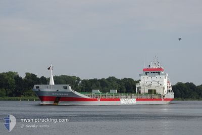
DONGEBORG
General Cargo

Current Trip
| Time Travelled | 9 h, 29 mins |
|---|---|
| Remaining Time | 2 days |
| Distance Travelled | 86.27 nm |
| Remaining Distance | 601.21 nm |
| AVG Speed | 9.4 Knopen |
| MAX Speed | 11.1 Knopen |
| AVG Wind | 7.9 knots |
| MAX Wind | 12.8 knots |
| MIN Temp | 9.7°C / 49.46°F |
| MAX Temp | 10.9°C / 51.62°F |
| Diepgang | 5.8 M |
| Positie ontvangen | 1 h, 16 m geleden |
Current Position
| Lengtegraad | 22.32393° |
|---|---|
| Breedtegraat | 59.40503° |
| Status | Under way using engine |
| Snelheid | 10.8 Knopen |
| Koers | 232.5° |
| Gebied | Baltic Sea |
| Station | T-AIS |
| Positie ontvangen | 1 h, 16 m geleden |
Information
The current position of DONGEBORG is in Baltic Sea with coordinates 59.40503° / 22.32393° as reported on 2025-06-06 03:59 by AIS to our vessel tracker app. The vessel's current speed is 10.8 Knopen and is heading at the port of SKAGEN. The estimated time of arrival as calculated by MyShipTracking vessel tracking app is 2025-06-08 13:12 LT
The vessel DONGEBORG (IMO: 9163697, MMSI: 245413000) is a General Cargo that was built in 1999 ( 26 Jaar oud ). It's sailing under the flag of [NL] Netherlands.
In this page you can find informations about the vessels current position, last detected port calls, and current voyage information. If the vessels is not in coverage by AIS you will find the latest position.
The current position of DONGEBORG is detected by our AIS receivers and we are not responsible for the reliability of the data. The last position was recorded while the vessel was in Coverage by the Ais receivers of our vessel tracking app.
The current draught of DONGEBORG as reported by AIS is 5.8 meters
Weather
| Temperature | 10.7°C / 51.26°F |
|---|---|
| Wind Speed | 12 knots |
| Direction | 193° SSW |
| Pressure | 1007.6 hPa |
| Humidity | 86 % |
| Cloud Coverage | 100 % |


Featured Company
Last Port Calls
| Port | Arrival | Departure | Time In Port |
|---|---|---|---|
| 2025-06-04 10:19 | 2025-06-05 22:47 | 1 d | |
| 2025-05-29 22:52 | 2025-05-31 01:39 | 1 d | |
| 2025-05-14 17:16 | 2025-05-16 18:39 | 2 d | |
| 2025-04-25 07:24 | 2025-04-26 12:09 | 1 d | |
| 2025-04-20 19:13 | 2025-04-21 19:15 | 1 d | |
| 2025-04-19 05:22 | 2025-04-19 20:30 | 15 h | |
| 2025-04-01 22:56 | 2025-04-04 16:19 | 2 d |
Most Visited Ports (Last year)
| Port | Arrivals | |
|---|---|---|
| 4 | ||
| 3 | ||
| 3 | ||
| 3 | ||
| 2 | ||
| 2 |
Last Trips
| Origin | Departure | Destination | Arrival | Distance | |
|---|---|---|---|---|---|
| 2025-05-31 01:39 | 2025-06-04 10:19 | 1058.79 nm | |||
| 2025-05-16 18:39 | 2025-05-29 22:52 | 1912.59 nm | |||
| 2025-04-26 12:09 | 2025-05-14 17:16 | 697.16 nm | |||
| 2025-04-21 19:15 | 2025-04-25 07:24 | 826.04 nm | |||
| 2025-04-19 20:30 | 2025-04-20 19:13 | 273.02 nm | |||
| 2025-04-04 16:19 | 2025-04-19 05:22 | 2693.33 nm | |||
| 2025-03-31 22:18 | 2025-04-01 22:56 | 215.97 nm |
Events
| Tijd | Evenement | Details | Positie / Bestemming | Info |
|---|---|---|---|---|
| 2025-06-06 04:08 | Status Changed | Default Under way using engine |
59.38907 / 22.28170
SKAW ROAD
|
Snelheid: 10.8 kn Koers: 232.5° |
| 2025-06-06 03:59 | Buitenbereik |
59.40503 / 22.32393
Baltic Sea
SKAW ROAD
|
Snelheid: 10.8 kn Koers: 232.5° |
|
| 2025-06-06 03:31 | Status Changed | Under way using engine Default |
59.45711 / 22.45631
SKAW ROAD
|
Snelheid: 10.9 kn Koers: 232° |
| 2025-06-06 03:14 | Status Changed | Default Under way using engine |
59.48807 / 22.53523
SKAW ROAD
|
Snelheid: 10.8 kn Koers: 240.1° |
| 2025-06-06 01:34 | Gevonden in zee | Finnish part of the Baltic Sea |
59.56985 / 23.11140
Baltic Sea
SKAW ROAD
|
Snelheid: 10.8 kn Koers: 256.1° |
| 2025-06-05 22:37 | Wijzig zee gebeid | Finnish part of the Gulf of Finland Estonian part of the Gulf of Finland |
59.67441 / 24.12053
Gulf of Finland
SKAW ROAD
|
Snelheid: 10.7 kn Koers: 278.4° |
| 2025-06-05 19:47 | Vertrekhaven |
|
59.50253 / 24.95848
SKAW ROAD
|
Snelheid: 9.4 kn Koers: 22° |
| 2025-06-05 19:44 | Start beweging |
59.49799 / 24.94884
[EE] MUUGA
|
Snelheid: 6 kn Koers: 66° |
|
| 2025-06-05 19:42 | Status Changed | Under way using engine Moored |
59.49593 / 24.94254
[EE] MUUGA
|
Snelheid: 0.5 kn Koers: 359° |
| 2025-06-05 19:15 | Status Changed | Moored Default |
59.49479 / 24.94267
[EE] MUUGA
|
Snelheid: Koers: 311° |