
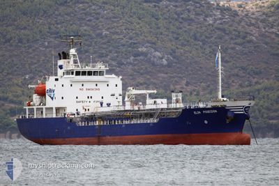
ELIN POSEIDON
Oil/Chemical Tanker
Current Trip
| Trip Time | 1 day |
|---|---|
| Trip Distance | 164.93 nm |
| AVG Speed | 9.4 Knopen |
| MAX Speed | 12.2 Knopen |
| Diepgang | 5.4 M |
| AVG Wind | 5.5 knots |
| MAX Wind | 23 knots |
| MIN Temp | 10°C / 50°F |
| MAX Temp | 15.2°C / 59.36°F |
| Positie ontvangen | 6 m geleden |
Current Position
| Lengtegraad | 24.09874° |
|---|---|
| Breedtegraat | 35.49675° |
| Status | At anchor |
| Snelheid | 0.1 Knopen |
| Koers | 24° |
| Gebied | Aegean Sea |
| Station | T-AIS |
| Positie ontvangen | 6 m geleden |
Info
Information
The current position of ELIN POSEIDON is in Aegean Sea with coordinates 35.49675° / 24.09874° as reported on 2025-03-03 23:09 by AIS to our vessel tracker app. The vessel's current speed is 0.1 Knopen and is currently inside the port of SOUDA.
The vessel ELIN POSEIDON (IMO: 9301677, MMSI: 241006000) is a Oil/Chemical Tanker that was built in 2005 ( 20 Jaar oud ). It's sailing under the flag of [GR] Greece.
In this page you can find informations about the vessels current position, last detected port calls, and current voyage information. If the vessels is not in coverage by AIS you will find the latest position.
The current position of ELIN POSEIDON is detected by our AIS receivers and we are not responsible for the reliability of the data. The last position was recorded while the vessel was in Coverage by the Ais receivers of our vessel tracking app.
The current draught of ELIN POSEIDON as reported by AIS is 5.4 meters
Weather
| Temperature | 9°C / 48.2°F |
|---|---|
| Wind Speed | 13 knots |
| Direction | 35° NE |
| Pressure | 1022 hPa |
| Humidity | 74.7 % |
| Cloud Coverage | 100 % |
Featured Company
Last Port Calls
| Port | Arrival | Departure | Time In Port |
|---|---|---|---|
| 2025-03-03 19:26 | |||
| 2025-03-02 10:43 | 2025-03-02 10:58 | 15 m | |
| 2025-03-01 13:38 | 2025-03-02 10:30 | 20 h | |
| 2025-02-28 05:32 | 2025-02-28 13:48 | 8 h | |
| 2025-02-24 21:12 | 2025-02-25 08:39 | 11 h | |
| 2025-02-19 12:18 | 2025-02-20 15:18 | 1 d | |
| 2025-02-16 06:15 | 2025-02-18 12:37 | 2 d | |
| 2025-02-14 16:37 | 2025-02-15 03:47 | 11 h | |
| 2025-02-12 13:16 | 2025-02-13 05:32 | 16 h | |
| 2025-02-10 15:32 | 2025-02-10 21:21 | 5 h |
Most Visited Ports (Last year)
| Port | Arrivals | |
|---|---|---|
| 35 | ||
| 26 | ||
| 22 | ||
| 21 | ||
| 15 | ||
| 3 |
Last Trips
| Origin | Departure | Destination | Arrival | Distance | |
|---|---|---|---|---|---|
| 2025-03-02 12:58 | 2025-03-03 21:26 | 164.93 nm | |||
| 2025-03-02 12:30 | 2025-03-02 12:43 | 0.39 nm | |||
| 2025-02-28 15:48 | 2025-03-01 15:38 | 254.66 nm | |||
| 2025-02-25 10:39 | 2025-02-28 07:32 | 379.13 nm | |||
| 2025-02-20 17:18 | 2025-02-24 23:12 | 651.61 nm | |||
| 2025-02-18 14:37 | 2025-02-19 14:18 | 183.98 nm | |||
| 2025-02-15 05:47 | 2025-02-16 08:15 | 180.27 nm | |||
| 2025-02-13 07:32 | 2025-02-14 18:37 | 181.80 nm | |||
| 2025-02-10 23:21 | 2025-02-12 15:16 | 3.82 nm | |||
| 2025-02-05 11:50 | 2025-02-10 17:32 | 219.60 nm |
Events
| Tijd | Evenement | Details | Positie / Bestemming | Info |
|---|---|---|---|---|
| 2025-03-03 19:45 | Stop beweging |
35.49645 / 24.10065
[GR] SOUDA
|
Snelheid: 0.2 kn Koers: 317° |
|
| 2025-03-03 19:39 | Status Changed | At anchor Under way using engine |
35.49783 / 24.09949
[GR] SOUDA
|
Snelheid: 0.5 kn Koers: 302° |
| 2025-03-03 19:26 | Aankomsthaven |
|
35.49364 / 24.11926
[GR] SOUDA
|
Snelheid: 6.3 kn Koers: 286° |
| 2025-03-03 19:21 | Status Changed | Under way using engine Moored |
35.49109 / 24.13034
GRSDH
|
Snelheid: 7.5 kn Koers: 281.1° |
| 2025-03-03 19:14 | Start beweging | 1.4 nm, West of MARATHI |
35.49526 / 24.14698
GRSDH
|
Snelheid: 5 kn Koers: 253.9° |
| 2025-03-03 05:30 | Status Changed | Moored Under way using engine |
35.49634 / 24.14969
GRSDH
|
Snelheid: Koers: 96° |
| 2025-03-03 05:16 | Stop beweging | 1.25 nm, West of MARATHI |
35.49632 / 24.14965
GRSDH
|
Snelheid: 0.3 kn Koers: 95° |
| 2025-03-03 04:43 | Start beweging | 1.44 nm, North East of KALYVES |
35.47294 / 24.19216
GRSDH
|
Snelheid: 4.8 kn Koers: 296° |
| 2025-03-03 04:38 | Status Changed | Under way using engine At anchor |
35.47302 / 24.19443
GRSDH
|
Snelheid: 0.6 kn Koers: 164° |
| 2025-03-03 01:50 | Status Changed | At anchor Under way using engine |
35.47147 / 24.19378
GRSDH
|
Snelheid: 0.1 kn Koers: 315° |