
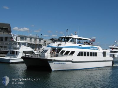
FLYING CLOUD
High speed craft
Current Trip
BOSTON
| Time Travelled | 6 h, 56 mins |
|---|---|
| Remaining Time | --- |
| Distance Travelled | 8.41 nm |
| Remaining Distance | --- |
| AVG Speed | 12.8 Knopen |
| MAX Speed | 12.8 Knopen |
| AVG Wind | 11.7 knots |
| MAX Wind | 12 knots |
| MIN Temp | 7.8°C / 46.04°F |
| MAX Temp | 8°C / 46.4°F |
| Diepgang | 2 M |
| Positie ontvangen | 5 h, 58 m geleden |
Current Position
| Lengtegraad | -70.97084° |
|---|---|
| Breedtegraat | 42.24369° |
| Status | Under way using engine |
| Snelheid | 0.1 Knopen |
| Koers | 288° |
| Gebied | North Atlantic Ocean |
| Station | T-AIS |
| Positie ontvangen | 5 h, 58 m geleden |
Info
Information
The current position of FLYING CLOUD is in North Atlantic Ocean with coordinates 42.24369° / -70.97084° as reported on 2026-01-09 19:49 by AIS to our vessel tracker app. The vessel's current speed is 0.1 Knopen
The vessel FLYING CLOUD (MMSI: 367578710) is a High speed craft It's sailing under the flag of [US] USA.
In this page you can find informations about the vessels current position, last detected port calls, and current voyage information. If the vessels is not in coverage by AIS you will find the latest position.
The current position of FLYING CLOUD is detected by our AIS receivers and we are not responsible for the reliability of the data. The last position was recorded while the vessel was in Coverage by the Ais receivers of our vessel tracking app.
The current draught of FLYING CLOUD as reported by AIS is 2 meters
Weather
| Temperature | 8°C / 46.4°F |
|---|---|
| Wind Speed | 12 knots |
| Direction | 197° SSW |
| Pressure | 1021.2 hPa |
| Humidity | 73.7 % |
| Cloud Coverage | 86 % |
Featured Company
Last Port Calls
| Port | Arrival | Departure | Time In Port |
|---|---|---|---|
| 2026-01-09 12:21 | 2026-01-09 13:51 | 1 h | |
| 2026-01-09 11:53 | 2026-01-09 12:03 | 9 m | |
| 2026-01-09 09:29 | 2026-01-09 11:17 | 1 h | |
| 2026-01-09 08:30 | 2026-01-09 08:51 | 21 m | |
| 2026-01-09 07:16 | 2026-01-09 07:48 | 32 m | |
| 2026-01-09 06:20 | 2026-01-09 06:46 | 26 m | |
| 2026-01-02 13:54 | 2026-01-02 13:59 | 4 m | |
| 2026-01-02 12:23 | 2026-01-02 13:10 | 46 m | |
| 2026-01-02 11:56 | 2026-01-02 12:03 | 7 m | |
| 2026-01-02 09:33 | 2026-01-02 11:18 | 1 h |
Most Visited Ports (Last year)
| Port | Arrivals | |
|---|---|---|
| 898 | ||
| 456 | ||
| 1 |
Last Trips
| Origin | Departure | Destination | Arrival | Distance | |
|---|---|---|---|---|---|
| 2026-01-09 12:03 | 2026-01-09 12:21 | 8.24 nm | |||
| 2026-01-09 11:17 | 2026-01-09 11:53 | 8.16 nm | |||
| 2026-01-09 08:51 | 2026-01-09 09:29 | 11.86 nm | |||
| 2026-01-09 07:48 | 2026-01-09 08:30 | 11.89 nm | |||
| 2026-01-09 06:46 | 2026-01-09 07:16 | 9.54 nm | |||
| 2026-01-02 13:59 | 2026-01-09 06:20 | 6.83 nm | |||
| 2026-01-02 13:10 | 2026-01-02 13:54 | 5.90 nm | |||
| 2026-01-02 12:03 | 2026-01-02 12:23 | 8.70 nm | |||
| 2026-01-02 11:18 | 2026-01-02 11:56 | 8.05 nm | |||
| 2026-01-02 08:52 | 2026-01-02 09:33 | 11.55 nm |
Events
| Tijd | Evenement | Details | Positie / Bestemming | Info |
|---|---|---|---|---|
| 2026-01-09 19:49 | Buitenbereik |
42.24369 / -70.97084
North Atlantic Ocean
|
Snelheid: 0.1 kn Koers: 269.6° |
|
| 2026-01-09 19:18 | Stop beweging | 2.33 nm, West of HINGHAM SHIPYARD |
42.24369 / -70.97085
BOSTON
|
Snelheid: 0.3 kn Koers: 292° |
| 2026-01-09 18:51 | Vertrekhaven |
|
42.34021 / -71.00619
BOSTON
|
Snelheid: 26.1 kn Koers: 163° |
| 2026-01-09 18:40 | Start beweging |
42.35975 / -71.04704
[US] BOSTON
|
Snelheid: 3.6 kn Koers: 116° |
|
| 2026-01-09 18:01 | Stop beweging |
42.35970 / -71.04959
[US] BOSTON
|
Snelheid: 0.1 kn Koers: 297° |
|
| 2026-01-09 17:56 | Start beweging |
42.36144 / -71.04761
[US] BOSTON
|
Snelheid: 6.5 kn Koers: 108° |
|
| 2026-01-09 17:50 | Stop beweging |
42.36103 / -71.05003
[US] BOSTON
|
Snelheid: 0.1 kn Koers: 231° |
|
| 2026-01-09 17:42 | Start beweging |
42.36024 / -71.03007
[US] BOSTON
|
Snelheid: 6.6 kn Koers: 289° |
|
| 2026-01-09 17:28 | Stop beweging |
42.36017 / -71.02757
[US] BOSTON
|
Snelheid: 0.2 kn Koers: 136° |
|
| 2026-01-09 17:21 | Aankomsthaven |
|
42.34140 / -71.00779
[US] BOSTON
|
Snelheid: 26.8 kn Koers: 318.8° |