
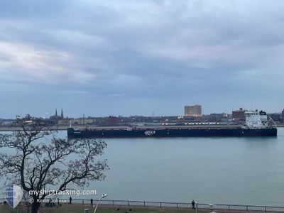
G3 MARQUIS
Cargo
Current Trip
| Time Travelled | 16 h, 30 mins |
|---|---|
| Remaining Time | 22 h, 16 mins |
| Distance Travelled | 75.21 nm |
| Remaining Distance | 250.73 nm |
| AVG Speed | 6.2 Knopen |
| MAX Speed | 11 Knopen |
| AVG Wind | 6.1 knots |
| MAX Wind | 9 knots |
| MIN Temp | 14.1°C / 57.38°F |
| MAX Temp | 24.5°C / 76.1°F |
| Diepgang | 7 M |
| Positie ontvangen | 6 h, 26 m geleden |
Current Position
| Lengtegraad | -74.30951° |
|---|---|
| Breedtegraat | 45.19173° |
| Status | Under way using engine |
| Snelheid | 10.4 Knopen |
| Koers | 210.3° |
| Gebied | Gulf of St-Lawrence |
| Station | T-AIS |
| Positie ontvangen | 6 h, 26 m geleden |
Info
Information
The current position of G3 MARQUIS is in Gulf of St-Lawrence with coordinates 45.19173° / -74.30951° as reported on 2025-06-04 04:26 by AIS to our vessel tracker app. The vessel's current speed is 10.4 Knopen and is heading at the port of HAMILTON. The estimated time of arrival as calculated by MyShipTracking vessel tracking app is 2025-06-05 09:08 LT
The vessel G3 MARQUIS (IMO: 9613941, MMSI: 316004370) is a Cargo It's sailing under the flag of [CA] Canada.
In this page you can find informations about the vessels current position, last detected port calls, and current voyage information. If the vessels is not in coverage by AIS you will find the latest position.
The current position of G3 MARQUIS is detected by our AIS receivers and we are not responsible for the reliability of the data. The last position was recorded while the vessel was in Coverage by the Ais receivers of our vessel tracking app.
The current draught of G3 MARQUIS as reported by AIS is 7 meters
Weather
| Temperature | 17°C / 62.6°F |
|---|---|
| Wind Speed | 9 knots |
| Direction | 203° SSW |
| Pressure | 1016.7 hPa |
| Humidity | 68.8 % |
| Cloud Coverage | 59 % |
Featured Company
Last Port Calls
| Port | Arrival | Departure | Time In Port |
|---|---|---|---|
| 2025-06-03 17:33 | 2025-06-03 18:22 | 49 m | |
| 2025-06-01 19:00 | 2025-06-02 06:20 | 11 h | |
| 2025-05-30 13:44 | 2025-05-31 13:40 | 23 h | |
| 2025-05-29 10:42 | 2025-05-29 12:09 | 1 h | |
| 2025-05-27 22:21 | 2025-05-27 23:28 | 1 h | |
| 2025-05-25 14:32 | 2025-05-25 16:29 | 1 h | |
| 2025-05-23 17:36 | 2025-05-24 19:15 | 1 d | |
| 2025-05-22 23:27 | 2025-05-22 23:56 | 28 m | |
| 2025-05-20 12:26 | 2025-05-20 13:06 | 40 m | |
| 2025-05-19 11:38 | 2025-05-20 09:27 | 21 h |
Most Visited Ports (Last year)
| Port | Arrivals | |
|---|---|---|
| 31 | ||
| 30 | ||
| 30 | ||
| 13 | ||
| 12 | ||
| 11 |
Last Trips
| Origin | Departure | Destination | Arrival | Distance | |
|---|---|---|---|---|---|
| 2025-06-02 02:20 | 2025-06-03 13:33 | 411.86 nm | |||
| 2025-05-31 09:40 | 2025-06-01 15:00 | 129.39 nm | |||
| 2025-05-29 08:09 | 2025-05-30 09:44 | 338.44 nm | |||
| 2025-05-27 19:28 | 2025-05-29 06:42 | 296.19 nm | |||
| 2025-05-25 12:29 | 2025-05-27 18:21 | 523.99 nm | |||
| 2025-05-24 15:15 | 2025-05-25 10:32 | 234.44 nm | |||
| 2025-05-22 19:56 | 2025-05-23 13:36 | 233.23 nm | |||
| 2025-05-20 09:06 | 2025-05-22 19:27 | 522.57 nm | |||
| 2025-05-20 05:27 | 2025-05-20 08:26 | 27.22 nm | |||
| 2025-05-17 19:56 | 2025-05-19 07:38 | 314.29 nm |
Events
| Tijd | Evenement | Details | Positie / Bestemming | Info |
|---|---|---|---|---|
| 2025-06-04 09:40 | Start beweging | 7.26 nm, West of CORNWALL |
44.97597 / -74.87203
HAMILTON
|
Snelheid: 8.4 kn Koers: 257° |
| 2025-06-04 09:15 | Stop beweging | 6.25 nm, West of CORNWALL |
44.97954 / -74.84861
HAMILTON
|
Snelheid: Koers: 260° |
| 2025-06-04 08:11 | Start beweging | 3.5 nm, South West of CORNWALL |
44.98719 / -74.78303
HAMILTON
|
Snelheid: 3.2 kn Koers: 260° |
| 2025-06-04 07:47 | Stop beweging | 3.23 nm, South West of CORNWALL |
44.98802 / -74.77656
HAMILTON
|
Snelheid: 0.1 kn Koers: 260° |
| 2025-06-04 04:37 | Status Changed | Default Under way using engine |
45.16965 / -74.34196
HAMILTON
|
Snelheid: 10.4 kn Koers: 210.3° |
| 2025-06-04 04:26 | Buitenbereik |
45.19173 / -74.30951
Gulf of St-Lawrence
HAMILTON
|
Snelheid: 10.4 kn Koers: 210.3° |
|
| 2025-06-04 04:25 | Status Changed | Under way using engine Default |
45.19257 / -74.30882
HAMILTON
|
Snelheid: 10.6 kn Koers: 210° |
| 2025-06-04 04:22 | Status Changed | Default Under way using engine |
45.20051 / -74.30231
HAMILTON
|
Snelheid: 11 kn Koers: 242.2° |
| 2025-06-04 04:13 | Status Changed | Under way using engine Default |
45.21729 / -74.27224
HAMILTON
|
Snelheid: 11.1 kn Koers: 261° |
| 2025-06-04 04:07 | Status Changed | Default Under way using engine |
45.22604 / -74.24766
HAMILTON
|
Snelheid: 10.5 kn Koers: 262.7° |