
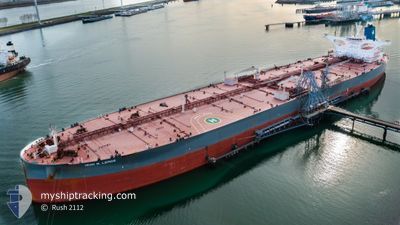
IRINI N. LEMOS
Tanker
Current Trip
| Time Travelled | --- |
|---|---|
| Remaining Time | --- |
| Distance Travelled | 13596.18 nm |
| Remaining Distance | --- |
| AVG Speed | 11.9 Knopen |
| MAX Speed | 15.9 Knopen |
| AVG Wind | 8.3 knots |
| MAX Wind | 31.4 knots |
| MIN Temp | 21.3°C / 70.34°F |
| MAX Temp | 30.1°C / 86.18°F |
| Diepgang | 19.6 M |
| Positie ontvangen | 3 d geleden |
Current Position
| Lengtegraad | 103.33540° |
|---|---|
| Breedtegraat | 1.29187° |
| Status | Under way using engine |
| Snelheid | 14.2 Knopen |
| Koers | 307.7° |
| Gebied | Malacca Strait |
| Station | T-AIS |
| Positie ontvangen | 3 d geleden |
Info
Information
The current position of IRINI N. LEMOS is in Malacca Strait with coordinates 1.29187° / 103.33540° as reported on 2025-02-08 09:29 by AIS to our vessel tracker app. The vessel's current speed is 14.2 Knopen and is heading at the port of PORTO DO ACU. The estimated time of arrival as calculated by MyShipTracking vessel tracking app is 2025-03-06 08:00 LT
The vessel IRINI N. LEMOS (IMO: 9831218, MMSI: 248643000) is a Tanker It's sailing under the flag of [MT] Malta.
In this page you can find informations about the vessels current position, last detected port calls, and current voyage information. If the vessels is not in coverage by AIS you will find the latest position.
The current position of IRINI N. LEMOS is detected by our AIS receivers and we are not responsible for the reliability of the data. The last position was recorded while the vessel was in Coverage by the Ais receivers of our vessel tracking app.
The current draught of IRINI N. LEMOS as reported by AIS is 19.6 meters
Weather
| Temperature | 28.3°C / 82.94°F |
|---|---|
| Wind Speed | 13 knots |
| Direction | 357° N |
| Pressure | 1009.4 hPa |
| Humidity | 75.6 % |
| Cloud Coverage | 97 % |
Featured Company
Last Port Calls
Last Trips
| Origin | Departure | Destination | Arrival | Distance |
|---|
Events
| Tijd | Evenement | Details | Positie / Bestemming | Info |
|---|---|---|---|---|
| 2025-02-08 09:37 | Status Changed | Default Under way using engine |
1.31265 / 103.30870
BRACX
|
Snelheid: 14.2 kn Koers: 307.7° |
| 2025-02-08 09:29 | Buitenbereik |
1.29187 / 103.33540
Malacca Strait
BRACX
|
Snelheid: 14.2 kn Koers: 307.7° |
|
| 2025-02-08 09:25 | Status Changed | Under way using engine Default |
1.28282 / 103.34696
BRACX
|
Snelheid: 14.2 kn Koers: 308° |
| 2025-02-08 09:21 | Status Changed | Default Under way using engine |
1.27329 / 103.35920
BRACX
|
Snelheid: 14.2 kn Koers: 306.2° |
| 2025-02-08 08:53 | Wijzig zee gebeid | Malaysian part of the Malacca Strait Malaysian part of the Singapore Strait |
1.22851 / 103.45797
Malacca Strait
BRACX
|
Snelheid: 13.9 kn Koers: 281.7° |
| 2025-02-08 08:17 | Wijzig zee gebeid | Malaysian part of the Singapore Strait Indonesian part of the Singapore Strait |
1.20042 / 103.59082
Singapore Strait
BRACX
|
Snelheid: 13 kn Koers: 279.2° |
| 2025-02-08 07:56 | Wijzig zee gebeid | Indonesian part of the Singapore Strait Singaporean part of the Singapore Strait |
1.18491 / 103.66291
Singapore Strait
BRACX
|
Snelheid: 12.2 kn Koers: 296.9° |
| 2025-02-08 06:08 | Wijzig zee gebeid | Singaporean part of the Singapore Strait Indonesian part of the Singapore Strait |
1.25489 / 103.99720
Singapore Strait
BRACX
|
Snelheid: 11.7 kn Koers: 253.9° |
| 2025-02-08 05:50 | Wijzig zee gebeid | Indonesian part of the Singapore Strait Singaporean part of the Singapore Strait |
1.27049 / 104.05016
Singapore Strait
BRACX
|
Snelheid: 10.7 kn Koers: 251.7° |
| 2025-02-08 05:46 | Wijzig zee gebeid | Singaporean part of the Singapore Strait Malaysian part of the Singapore Strait |
1.27468 / 104.05887
Singapore Strait
BRACX
|
Snelheid: 9.7 kn Koers: 243.5° |