
JACKIE
Wing in ground B
Current Trip
MANCHAC
| Time Travelled | --- |
|---|---|
| Remaining Time | --- |
| Distance Travelled | --- |
| Remaining Distance | --- |
| AVG Speed | --- |
| MAX Speed | --- |
| AVG Wind | --- |
| MAX Wind | --- |
| MIN Temp | --- |
| MAX Temp | --- |
| Diepgang | 2.3 M |
| Positie ontvangen | 3 m geleden |
Current Position
| Lengtegraad | -93.66943° |
|---|---|
| Breedtegraat | 30.05815° |
| Status | Default |
| Snelheid | |
| Koers | --- |
| Gebied | Gulf of Mexico |
| Station | T-AIS |
| Positie ontvangen | 3 m geleden |
Info
Information
The current position of JACKIE is in Gulf of Mexico with coordinates 30.05815° / -93.66943° as reported on 2025-02-22 05:15 by AIS to our vessel tracker app. The vessel's current speed is 0 Knopen
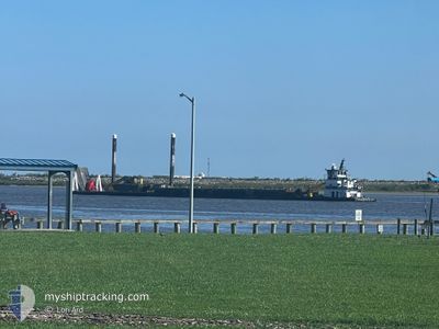
The vessel JACKIE (MMSI: 367129820) is a Wing in ground B It's sailing under the flag of [US] USA.
In this page you can find informations about the vessels current position, last detected port calls, and current voyage information. If the vessels is not in coverage by AIS you will find the latest position.
The current position of JACKIE is detected by our AIS receivers and we are not responsible for the reliability of the data. The last position was recorded while the vessel was in Coverage by the Ais receivers of our vessel tracking app.
The current draught of JACKIE as reported by AIS is 2.3 meters
Weather
| Temperature | 3.8°C / 38.84°F |
|---|---|
| Wind Speed | 7 knots |
| Direction | 54° NE |
| Pressure | 1031.5 hPa |
| Humidity | 51.5 % |
| Cloud Coverage | 100 % |
Featured Company
Last Port Calls
| Port | Arrival | Departure | Time In Port |
|---|---|---|---|
| 2025-02-18 04:50 | |||
| 2025-01-01 18:04 | |||
| 2024-12-22 14:05 | 2024-12-30 15:43 | 8 d | |
| 2024-12-22 02:26 | 2024-12-22 03:58 | 1 h | |
| 2024-12-21 01:05 | 2024-12-22 00:53 | 23 h | |
| 2024-12-16 19:13 | 2024-12-16 20:28 | 1 h | |
| 2024-12-12 22:08 | 2024-12-15 15:53 | 2 d | |
| 2024-12-10 08:04 | 2024-12-10 19:09 | 11 h | |
| 2024-12-09 13:57 | 2024-12-09 18:19 | 4 h | |
| 2024-12-06 12:54 | 2024-12-09 06:08 | 2 d |
Most Visited Ports (Last year)
| Port | Arrivals | |
|---|---|---|
| 16 | ||
| 14 | ||
| 10 | ||
| 9 | ||
| 7 | ||
| 4 |
Last Trips
| Origin | Departure | Destination | Arrival | Distance | |
|---|---|---|---|---|---|
| 2024-12-30 09:43 | 2025-01-01 12:04 | 87.40 nm | |||
| 2024-12-21 21:58 | 2024-12-22 08:05 | 51.60 nm | |||
| 2024-12-21 18:53 | 2024-12-21 20:26 | 4.53 nm | |||
| 2024-12-16 14:28 | 2024-12-20 19:05 | 86.23 nm | |||
| 2024-12-15 09:53 | 2024-12-16 13:13 | 18.74 nm | |||
| 2024-12-10 13:09 | 2024-12-12 16:08 | 88.29 nm | |||
| 2024-12-09 12:19 | 2024-12-10 02:04 | 65.49 nm | |||
| 2024-12-09 00:08 | 2024-12-09 07:57 | 13.12 nm | |||
| 2024-12-05 20:43 | 2024-12-06 06:54 | 9.46 nm | |||
| 2024-12-03 14:31 | 2024-12-05 07:33 | 71.39 nm |
Events
| Tijd | Evenement | Details | Positie / Bestemming | Info |
|---|---|---|---|---|
| 2025-02-21 22:36 | Stop beweging | 4.04 nm, East of ORANGE |
30.05817 / -93.66942
MANCHAC
|
Snelheid: 0.1 kn Koers: 511° |
| 2025-02-21 22:04 | Start beweging | 1.23 nm, East of ORANGE |
30.06818 / -93.72324
MANCHAC
|
Snelheid: 6.3 kn Koers: 141° |
| 2025-02-21 20:09 | Stop beweging | 1.16 nm, East of ORANGE |
30.06946 / -93.72479
MANCHAC
|
Snelheid: 0.1 kn Koers: 511° |
| 2025-02-21 19:33 | Start beweging | 3.97 nm, East of ORANGE |
30.05861 / -93.67076
MANCHAC
|
Snelheid: 6.3 kn Koers: 272° |
| 2025-02-21 18:45 | Stop beweging | 4.1 nm, East of ORANGE |
30.05823 / -93.66829
MANCHAC
|
Snelheid: Koers: 511° |
| 2025-02-21 17:59 | Start beweging | 5.54 nm, East of ORANGE |
30.05878 / -93.64044
MANCHAC
|
Snelheid: 6.8 kn Koers: 268.8° |
| 2025-02-21 17:20 | Stop beweging | 5.96 nm, East of ORANGE |
30.05869 / -93.63231
MANCHAC
|
Snelheid: 0.2 kn Koers: 511° |
| 2025-02-21 17:10 | Start beweging | 5.35 nm, East of ORANGE |
30.05871 / -93.64400
MANCHAC
|
Snelheid: 4.7 kn Koers: 95.4° |
| 2025-02-21 12:55 | Stop beweging | 5.25 nm, East of ORANGE |
30.05822 / -93.64610
MANCHAC
|
Snelheid: Koers: 511° |
| 2025-02-21 12:55 | Start beweging | 5.23 nm, East of ORANGE |
30.05832 / -93.64645
MANCHAC
|
Snelheid: 3.1 kn Koers: 101.2° |