
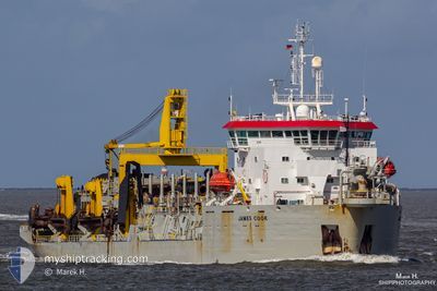
JAMES COOK
Trailing Suction Hopper Dredger
Current Trip
| Trip Time | 6 days |
|---|---|
| Trip Distance | 382.25 nm |
| AVG Speed | 7.6 Knopen |
| MAX Speed | 7.6 Knopen |
| Diepgang | 6.9 M |
| AVG Wind | 19.6 knots |
| MAX Wind | 32 knots |
| MIN Temp | 14.7°C / 58.46°F |
| MAX Temp | 20°C / 68°F |
| Positie ontvangen | 27 d geleden |
Current Position
| Lengtegraad | 104.04041° |
|---|---|
| Breedtegraat | 1.25261° |
| Status | Under way using engine |
| Snelheid | 11.5 Knopen |
| Koers | 80.7° |
| Gebied | Singapore Strait |
| Station | T-AIS |
| Positie ontvangen | 27 d geleden |
Info
Information
The current position of JAMES COOK is in Singapore Strait with coordinates 1.25261° / 104.04041° as reported on 2025-01-10 21:46 by AIS to our vessel tracker app. The vessel's current speed is 11.5 Knopen and is currently inside the port of TAICHUNG.
The vessel JAMES COOK (IMO: 9020261, MMSI: 253254000) is a Trailing Suction Hopper Dredger that was built in 1992 ( 33 Jaar oud ). It's sailing under the flag of [LU] Luxembourg.
In this page you can find informations about the vessels current position, last detected port calls, and current voyage information. If the vessels is not in coverage by AIS you will find the latest position.
The current position of JAMES COOK is detected by our AIS receivers and we are not responsible for the reliability of the data. The last position was recorded while the vessel was in Coverage by the Ais receivers of our vessel tracking app.
The current draught of JAMES COOK as reported by AIS is 6.9 meters
Weather
| Temperature | 12.7°C / 54.86°F |
|---|---|
| Wind Speed | 31 knots |
| Direction | 26° NNE |
| Pressure | 1021.9 hPa |
| Humidity | 72.3 % |
| Cloud Coverage | 18 % |
Featured Company
Events
| Tijd | Evenement | Details | Positie / Bestemming | Info |
|---|---|---|---|---|
| 2025-02-06 17:49 | Stop beweging |
24.24022 / 120.50099
[TW] TAICHUNG
|
Snelheid: Koers: 202° |
|
| 2025-02-06 17:09 | Aankomsthaven |
|
24.29120 / 120.50175
[TW] TAICHUNG
|
Snelheid: 7.4 kn Koers: 72° |
| 2025-02-06 12:33 | Start beweging | 21.45 nm, North West of MAILIAO |
24.02231 / 119.87778
TWAPG
|
Snelheid: 12.8 kn Koers: 90° |
| 2025-02-06 12:14 | Stop beweging |
24.01443 / 119.84617
TWAPG
|
Snelheid: Koers: 6° |
|
| 2025-02-06 08:09 | Start beweging | 20.09 nm, North West of MAILIAO |
24.00145 / 119.89076
TWAPG
|
Snelheid: 3.1 kn Koers: 221° |
| 2025-02-06 07:53 | Stop beweging | 20.1 nm, North West of MAILIAO |
24.00295 / 119.89185
TWAPG
|
Snelheid: 0.2 kn Koers: 228° |
| 2025-02-06 07:01 | Start beweging | 21.16 nm, North West of MAILIAO |
23.98060 / 119.84935
TWAPG
|
Snelheid: 6.7 kn Koers: 92° |
| 2025-02-06 06:36 | Stop beweging |
23.98061 / 119.83020
TWAPG
|
Snelheid: 0.1 kn Koers: 202° |
|
| 2025-02-06 06:21 | Start beweging |
23.97193 / 119.83289
TWAPG
|
Snelheid: 7 kn Koers: 310° |
|
| 2025-02-06 03:33 | Stop beweging | 20.09 nm, North West of MAILIAO |
24.00001 / 119.88936
TWAPG
|
Snelheid: Koers: 218° |