
JPO LIBRA
Container Ship
Current Trip
| Time Travelled | 2 days |
|---|---|
| Remaining Time | --- |
| Distance Travelled | 1198.70 nm |
| Remaining Distance | 647.87 nm |
| AVG Speed | 17.6 Knopen |
| MAX Speed | 21.4 Knopen |
| AVG Wind | 14.7 knots |
| MAX Wind | 25 knots |
| MIN Temp | -0.2°C / 31.64°F |
| MAX Temp | 15.7°C / 60.26°F |
| Diepgang | 8.8 M |
| Positie ontvangen | 2 d geleden |
Current Position
| Lengtegraad | 23.56919° |
|---|---|
| Breedtegraat | 36.83996° |
| Status | Under way using engine |
| Snelheid | 21 Knopen |
| Koers | 211.2° |
| Gebied | Aegean Sea |
| Station | T-AIS |
| Positie ontvangen | 2 d geleden |
Info
Information
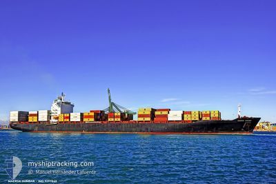
The current position of JPO LIBRA is in Aegean Sea with coordinates 36.83996° / 23.56919° as reported on 2025-02-12 09:49 by AIS to our vessel tracker app. The vessel's current speed is 21 Knopen and is heading at the port of TANGER MED. The estimated time of arrival as calculated by MyShipTracking vessel tracking app is 2025-02-15 20:30 LT
The vessel JPO LIBRA (IMO: 9297840, MMSI: 636090862) is a Container Ship that was built in 2005 ( 20 Jaar oud ). It's sailing under the flag of [LR] Liberia.
In this page you can find informations about the vessels current position, last detected port calls, and current voyage information. If the vessels is not in coverage by AIS you will find the latest position.
The current position of JPO LIBRA is detected by our AIS receivers and we are not responsible for the reliability of the data. The last position was recorded while the vessel was in Coverage by the Ais receivers of our vessel tracking app.
The current draught of JPO LIBRA as reported by AIS is 8.8 meters
Weather
| Temperature | 14.5°C / 58.1°F |
|---|---|
| Wind Speed | 12 knots |
| Direction | 287° WNW |
| Pressure | 1019.4 hPa |
| Humidity | 77.8 % |
| Cloud Coverage | 74 % |
Featured Company
Last Port Calls
| Port | Arrival | Departure | Time In Port |
|---|---|---|---|
| 2025-02-09 16:28 | 2025-02-11 12:29 | 1 d | |
| 2025-02-06 13:03 | 2025-02-06 23:27 | 10 h | |
| 2025-02-04 11:40 | 2025-02-05 05:21 | 17 h | |
| 2025-02-02 22:07 | 2025-02-03 15:24 | 17 h | |
| 2025-01-29 06:19 | 2025-01-29 22:30 | 16 h | |
| 2025-01-28 04:05 | 2025-01-28 20:41 | 16 h | |
| 2025-01-17 01:08 | 2025-01-17 19:17 | 18 h | |
| 2025-01-15 16:34 | 2025-01-16 10:23 | 17 h | |
| 2025-01-11 20:03 | |||
| 2025-01-07 12:28 | 2025-01-09 00:31 | 1 d |
Most Visited Ports (Last year)
| Port | Arrivals | |
|---|---|---|
| 10 | ||
| 5 | ||
| 5 | ||
| 5 | ||
| 4 | ||
| 4 |
Last Trips
| Origin | Departure | Destination | Arrival | Distance | |
|---|---|---|---|---|---|
| 2025-02-07 02:27 | 2025-02-09 19:28 | 83.14 nm | |||
| 2025-02-05 07:21 | 2025-02-06 16:03 | 367.10 nm | |||
| 2025-02-03 17:24 | 2025-02-04 13:40 | 264.10 nm | |||
| 2025-01-29 23:30 | 2025-02-03 00:07 | 1515.16 nm | |||
| 2025-01-28 21:41 | 2025-01-29 07:19 | 58.37 nm | |||
| 2025-01-17 14:17 | 2025-01-28 05:05 | 4398.76 nm | |||
| 2025-01-16 05:23 | 2025-01-16 20:08 | 51.19 nm | |||
| 2025-01-11 15:03 | 2025-01-15 11:34 | 829.93 nm | |||
| 2025-01-06 05:55 | 2025-01-07 07:28 | 361.36 nm | |||
| 2025-01-03 18:05 | 2025-01-05 20:49 | 417.10 nm |
Events
| Tijd | Evenement | Details | Positie / Bestemming | Info |
|---|---|---|---|---|
| 2025-02-12 09:58 | Status Changed | Default Under way using engine |
36.79335 / 23.53411
MAPTM01
|
Snelheid: 21 kn Koers: 211.2° |
| 2025-02-12 09:49 | Status Changed | Under way using engine Default |
36.83996 / 23.56919
MAPTM01
|
Snelheid: 20.9 kn Koers: 213° |
| 2025-02-12 09:49 | Buitenbereik |
36.83996 / 23.56919
Aegean Sea
MAPTM01
|
Snelheid: 21 kn Koers: 211.2° |
|
| 2025-02-12 09:43 | Binnenbereik |
36.83996 / 23.56919
Aegean Sea
MAPTM01
|
Snelheid: 21 kn Koers: 211.2° |
|
| 2025-02-12 08:13 | Status Changed | Default Under way using engine |
37.31726 / 23.93906
MAPTM01
|
Snelheid: 21.1 kn Koers: 210.8° |
| 2025-02-12 08:07 | Buitenbereik |
37.34816 / 23.96201
Aegean Sea
MAPTM01
|
Snelheid: 21.1 kn Koers: 210.8° |
|
| 2025-02-12 02:55 | Status Changed | Under way using engine Default |
38.70469 / 25.06910
MAPTM01
|
Snelheid: 17.2 kn Koers: 207° |
| 2025-02-12 02:37 | Binnenbereik |
38.70425 / 25.06883
Aegean Sea
MAPTM01
|
Snelheid: 17.6 kn Koers: 206.1° |
|
| 2025-02-12 00:20 | Status Changed | Default Under way using engine |
39.37993 / 25.48921
MAPTM01
|
Snelheid: 17.2 kn Koers: 207.7° |
| 2025-02-11 23:48 | Buitenbereik |
39.52123 / 25.58228
Aegean Sea
MAPTM01
|
Snelheid: 17.2 kn Koers: 207.7° |