
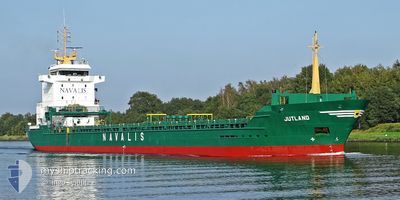
JUTLAND
General Cargo
Current Trip
SEDOM
| Time Travelled | 15 h, 54 mins |
|---|---|
| Remaining Time | --- |
| Distance Travelled | 156.09 nm |
| Remaining Distance | --- |
| AVG Speed | 10.5 Knopen |
| MAX Speed | 12.3 Knopen |
| AVG Wind | 14.9 knots |
| MAX Wind | 22 knots |
| MIN Temp | -11.4°C / 11.48°F |
| MAX Temp | -4.8°C / 23.36°F |
| Diepgang | 4.5 M |
| Positie ontvangen | 15 h, 0 m geleden |
Current Position
| Lengtegraad | 22.48338° |
|---|---|
| Breedtegraat | 65.46311° |
| Status | Under way using engine |
| Snelheid | 11.3 Knopen |
| Koers | 142.1° |
| Gebied | Gulf of Bothnia |
| Station | T-AIS |
| Positie ontvangen | 15 h, 0 m geleden |
Info
Information
The current position of JUTLAND is in Gulf of Bothnia with coordinates 65.46311° / 22.48338° as reported on 2025-02-14 22:55 by AIS to our vessel tracker app. The vessel's current speed is 11.3 Knopen
The vessel JUTLAND (IMO: 9277345, MMSI: 209314000) is a General Cargo that was built in 2004 ( 21 Jaar oud ). It's sailing under the flag of [CY] Cyprus.
In this page you can find informations about the vessels current position, last detected port calls, and current voyage information. If the vessels is not in coverage by AIS you will find the latest position.
The current position of JUTLAND is detected by our AIS receivers and we are not responsible for the reliability of the data. The last position was recorded while the vessel was in Coverage by the Ais receivers of our vessel tracking app.
The current draught of JUTLAND as reported by AIS is 4.5 meters
Weather
| Temperature | -5.2°C / 22.64°F |
|---|---|
| Wind Speed | 16 knots |
| Direction | 355° N |
| Pressure | 1025.5 hPa |
| Humidity | 75.2 % |
| Cloud Coverage | 81 % |
Featured Company
Last Port Calls
| Port | Arrival | Departure | Time In Port |
|---|---|---|---|
| 2025-02-13 16:39 | 2025-02-14 23:01 | 1 d | |
| 2025-02-06 14:45 | 2025-02-07 21:46 | 1 d | |
| 2025-02-02 11:38 | 2025-02-05 23:29 | 3 d | |
| 2025-01-25 19:41 | 2025-01-29 01:41 | 3 d | |
| 2025-01-24 06:26 | 2025-01-24 15:53 | 9 h | |
| 2025-01-16 17:20 | 2025-01-18 16:38 | 1 d | |
| 2025-01-16 02:17 | 2025-01-16 02:28 | 10 m | |
| 2025-01-13 18:53 | |||
| 2025-01-06 06:45 | 2025-01-09 18:33 | 3 d | |
| 2025-01-04 18:01 | 2025-01-05 20:09 | 1 d |
Most Visited Ports (Last year)
| Port | Arrivals | |
|---|---|---|
| 10 | ||
| 8 | ||
| 7 | ||
| 5 | ||
| 5 | ||
| 3 |
Last Trips
| Origin | Departure | Destination | Arrival | Distance | |
|---|---|---|---|---|---|
| 2025-02-07 21:46 | 2025-02-13 16:39 | 1333.66 nm | |||
| 2025-02-05 23:29 | 2025-02-06 14:45 | 171.32 nm | |||
| 2025-01-29 01:41 | 2025-02-02 11:38 | 1032.49 nm | |||
| 2025-01-24 15:53 | 2025-01-25 19:41 | 269.99 nm | |||
| 2025-01-18 16:38 | 2025-01-24 06:26 | 1331.87 nm | |||
| 2025-01-16 02:28 | 2025-01-16 17:20 | 169.95 nm | |||
| 2025-01-09 18:33 | 2025-01-16 02:17 | 1038.69 nm | |||
| 2025-01-09 18:33 | 2025-01-13 18:53 | 1038.41 nm | |||
| 2025-01-05 20:09 | 2025-01-06 06:45 | 80.41 nm | |||
| 2025-01-03 20:58 | 2025-01-04 18:01 | 85.39 nm |
Events
| Tijd | Evenement | Details | Positie / Bestemming | Info |
|---|---|---|---|---|
| 2025-02-14 23:01 | Status Changed | Default Under way using engine |
65.44905 / 22.51200
SEDOM
|
Snelheid: 11.3 kn Koers: 142.1° |
| 2025-02-14 22:55 | Buitenbereik |
65.46311 / 22.48338
Gulf of Bothnia
SEDOM
|
Snelheid: 11.3 kn Koers: 142.1° |
|
| 2025-02-14 22:55 | Status Changed | Under way using engine Default |
65.46352 / 22.48262
SEDOM
|
Snelheid: 10.3 kn Koers: 145° |
| 2025-02-14 22:53 | Status Changed | Default Under way using engine |
65.46798 / 22.47456
SEDOM
|
Snelheid: 9 kn Koers: 144° |
| 2025-02-14 22:52 | Status Changed | Under way using engine Default |
65.46990 / 22.47137
SEDOM
|
Snelheid: 0.2 kn Koers: 133° |
| 2025-02-14 22:52 | Start beweging | 9.87 nm, South East of LULEA |
65.46990 / 22.47137
SEDOM
|
Snelheid: 9 kn Koers: 144° |
| 2025-02-14 22:49 | Stop beweging | 9.63 nm, South East of LULEA |
65.47312 / 22.46496
SEDOM
|
Snelheid: 0.2 kn Koers: 133° |
| 2025-02-14 22:37 | Start beweging | 8.28 nm, South East of LULEA |
65.48761 / 22.42386
SEDOM
|
Snelheid: 8.6 kn Koers: 127° |
| 2025-02-14 22:33 | Stop beweging | 8.03 nm, South East of LULEA |
65.49003 / 22.41577
SEDOM
|
Snelheid: Koers: 125° |
| 2025-02-14 22:25 | Status Changed | Default Under way using engine |
65.49316 / 22.40594
SEDOM
|
Snelheid: 11.8 kn Koers: 129.3° |