
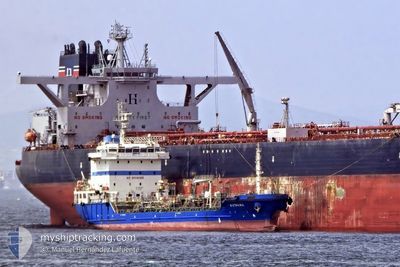
KYTHIRA
Tanker
Current Trip
EG DAM
| Time Travelled | 1 day |
|---|---|
| Remaining Time | --- |
| Distance Travelled | 13.71 nm |
| Remaining Distance | --- |
| AVG Speed | 7.2 Knopen |
| MAX Speed | 8.4 Knopen |
| AVG Wind | 24.2 knots |
| MAX Wind | 28.7 knots |
| MIN Temp | 16.8°C / 62.24°F |
| MAX Temp | 17.8°C / 64.04°F |
| Diepgang | 6.1 M |
| Positie ontvangen | 2 d geleden |
Current Position
| Lengtegraad | 31.75585° |
|---|---|
| Breedtegraat | 31.56192° |
| Status | At anchor |
| Snelheid | |
| Koers | 137° |
| Gebied | Mediterranean Sea - Eastern Basin |
| Station | T-AIS |
| Positie ontvangen | 2 d geleden |
Info
Information
The current position of KYTHIRA is in Mediterranean Sea - Eastern Basin with coordinates 31.56192° / 31.75585° as reported on 2026-01-08 06:13 by AIS to our vessel tracker app. The vessel's current speed is 0 Knopen
The vessel KYTHIRA (IMO: 9417543, MMSI: 248338000) is a Tanker It's sailing under the flag of [MT] Malta.
In this page you can find informations about the vessels current position, last detected port calls, and current voyage information. If the vessels is not in coverage by AIS you will find the latest position.
The current position of KYTHIRA is detected by our AIS receivers and we are not responsible for the reliability of the data. The last position was recorded while the vessel was in Coverage by the Ais receivers of our vessel tracking app.
The current draught of KYTHIRA as reported by AIS is 6.1 meters
Weather
| Temperature | 18.4°C / 65.12°F |
|---|---|
| Wind Speed | 12 knots |
| Direction | 266° W |
| Pressure | 1019.1 hPa |
| Humidity | 68.8 % |
| Cloud Coverage | 45 % |
Featured Company
Last Port Calls
| Port | Arrival | Departure | Time In Port |
|---|---|---|---|
| 2026-01-08 23:55 | 2026-01-09 08:31 | 8 h | |
| 2026-01-06 20:42 | 2026-01-07 17:04 | 20 h | |
| 2025-12-23 07:46 | 2025-12-23 22:19 | 14 h | |
| 2025-12-19 16:25 | 2025-12-20 02:17 | 9 h | |
| 2025-12-18 00:34 | 2025-12-18 12:26 | 11 h | |
| 2025-12-16 01:03 | 2025-12-16 20:47 | 19 h | |
| 2025-12-04 12:05 | 2025-12-05 04:41 | 16 h | |
| 2025-11-29 19:17 | 2025-11-30 10:29 | 15 h | |
| 2025-11-26 22:28 | 2025-11-27 10:13 | 11 h | |
| 2025-11-20 03:13 | 2025-11-20 16:04 | 12 h |
Most Visited Ports (Last year)
| Port | Arrivals | |
|---|---|---|
| 36 | ||
| 30 | ||
| 5 | ||
| 1 | ||
| 1 |
Last Trips
| Origin | Departure | Destination | Arrival | Distance | |
|---|---|---|---|---|---|
| 2026-01-07 17:04 | 2026-01-08 23:55 | 10.65 nm | |||
| 2025-12-23 22:19 | 2026-01-06 20:42 | 217.18 nm | |||
| 2025-12-18 12:26 | 2025-12-23 07:46 | 239.64 nm | |||
| 2025-12-18 12:26 | 2025-12-19 16:25 | 73.89 nm | |||
| 2025-12-16 20:47 | 2025-12-18 00:34 | 107.42 nm | |||
| 2025-12-05 04:41 | 2025-12-16 01:03 | 179.56 nm | |||
| 2025-11-27 10:13 | 2025-12-04 12:05 | 183.16 nm | |||
| 2025-11-27 10:13 | 2025-11-29 19:17 | 87.05 nm | |||
| 2025-11-20 16:04 | 2025-11-26 22:28 | 183.73 nm | |||
| 2025-11-18 18:52 | 2025-11-20 03:13 | 115.43 nm |
Events
| Tijd | Evenement | Details | Positie / Bestemming | Info |
|---|---|---|---|---|
| 2026-01-10 00:23 | Stop beweging | 9.36 nm, North of DAMIETTA |
31.62106 / 31.72499
EG DAM
|
Snelheid: 0.3 kn Koers: 278° |
| 2026-01-09 17:11 | Start beweging | 8.42 nm, North of DAMIETTA |
31.60745 / 31.77302
EG DAM
|
Snelheid: 3.8 kn Koers: 286° |
| 2026-01-09 08:04 | Stop beweging | 8.82 nm, North of DAMIETTA |
31.61452 / 31.75188
EG DAM
|
Snelheid: 0.3 kn Koers: 271° |
| 2026-01-09 06:31 | Vertrekhaven |
|
31.50446 / 31.76246
EG DAM
|
Snelheid: 8.9 kn Koers: 11° |
| 2026-01-09 06:08 | Start beweging |
31.45359 / 31.76772
[EG] DAMIETTA
|
Snelheid: 4.9 kn Koers: 323° |
|
| 2026-01-08 21:55 | Aankomsthaven |
|
31.45182 / 31.76907
[EG] DAMIETTA
|
Snelheid: 1.8 kn Koers: 246° |
| 2026-01-08 06:19 | Status Changed | Default At anchor |
31.56195 / 31.75586
EG DAM
|
Snelheid: Koers: 137° |
| 2026-01-08 06:13 | Buitenbereik |
31.56192 / 31.75585
Mediterranean Sea - Eastern Basin
|
Snelheid: Koers: 3.6° |
|
| 2026-01-08 06:01 | Status Changed | At anchor Default |
31.56189 / 31.75575
EG DAM
|
Snelheid: Koers: 129° |
| 2026-01-08 06:01 | Binnenbereik |
31.56189 / 31.75575
Mediterranean Sea - Eastern Basin
|
Snelheid: 0.1 kn Koers: 290.5° |