
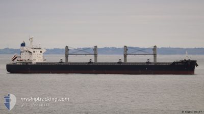
LA STELLA
Cargo
Current Trip
| Time Travelled | 5 days |
|---|---|
| Remaining Time | 1 day |
| Distance Travelled | 36.35 nm |
| Remaining Distance | 164.50 nm |
| AVG Speed | 5.4 Knopen |
| MAX Speed | 8.5 Knopen |
| AVG Wind | 16.3 knots |
| MAX Wind | 32 knots |
| MIN Temp | 13.6°C / 56.48°F |
| MAX Temp | 17.5°C / 63.5°F |
| Diepgang | 12.7 M |
| Positie ontvangen | 8 d geleden |
Current Position
| Lengtegraad | 18.43663° |
|---|---|
| Breedtegraat | 35.14231° |
| Status | Under way using engine |
| Snelheid | 11.4 Knopen |
| Koers | 109.6° |
| Gebied | Mediterranean Sea - Eastern Basin |
| Station | T-AIS |
| Positie ontvangen | 8 d geleden |
Info
Information
The current position of LA STELLA is in Mediterranean Sea - Eastern Basin with coordinates 35.14231° / 18.43663° as reported on 2025-01-28 17:29 by AIS to our vessel tracker app. The vessel's current speed is 11.4 Knopen and is heading at the port of DAMIETTA. The estimated time of arrival as calculated by MyShipTracking vessel tracking app is 2025-02-08 00:33 LT
The vessel LA STELLA (IMO: 9748368, MMSI: 205700000) is a Cargo It's sailing under the flag of [BE] Belgium.
In this page you can find informations about the vessels current position, last detected port calls, and current voyage information. If the vessels is not in coverage by AIS you will find the latest position.
The current position of LA STELLA is detected by our AIS receivers and we are not responsible for the reliability of the data. The last position was recorded while the vessel was in Coverage by the Ais receivers of our vessel tracking app.
The current draught of LA STELLA as reported by AIS is 12.7 meters
Weather
| Temperature | 13.2°C / 55.76°F |
|---|---|
| Wind Speed | 26 knots |
| Direction | 339° NNW |
| Pressure | 1020.4 hPa |
| Humidity | 58.9 % |
| Cloud Coverage | 78 % |
Featured Company
Last Port Calls
| Port | Arrival | Departure | Time In Port |
|---|---|---|---|
| 2025-01-31 00:45 | 2025-01-31 16:11 | 15 h | |
| 2024-12-17 20:28 | 2025-01-06 01:26 | 19 d |
Last Trips
| Origin | Departure | Destination | Arrival | Distance | |
|---|---|---|---|---|---|
| 2025-01-05 19:26 | 2025-01-31 02:45 | 6692.77 nm | |||
| 2024-11-22 00:51 | 2024-12-17 14:28 | 6290.69 nm |
Events
| Tijd | Evenement | Details | Positie / Bestemming | Info |
|---|---|---|---|---|
| 2025-02-06 07:08 | Start beweging | 15.97 nm, North West of EL DEKHEILA |
31.26624 / 29.52868
USMSY > EGDAM
|
Snelheid: 3.1 kn Koers: 331° |
| 2025-02-06 04:50 | Stop beweging | 13.75 nm, North West of EL DEKHEILA |
31.24628 / 29.56554
USMSY > EGDAM
|
Snelheid: 0.1 kn Koers: 324° |
| 2025-02-05 22:46 | Start beweging | 12.43 nm, North West of EL DEKHEILA |
31.25500 / 29.60019
USMSY > EGDAM
|
Snelheid: 4.2 kn Koers: 312° |
| 2025-01-31 18:05 | Stop beweging | 7.15 nm, North West of EL DEKHEILA |
31.22061 / 29.69716
USMSY > EGDAM
|
Snelheid: 0.3 kn Koers: 17° |
| 2025-01-31 16:11 | Vertrekhaven |
|
31.16051 / 29.84069
USMSY > EGDAM
|
Snelheid: 6.6 kn Koers: 230° |
| 2025-01-31 16:01 | Start beweging |
31.17108 / 29.85491
[EG] ALEXANDRIA
|
Snelheid: 3.5 kn Koers: 224° |
|
| 2025-01-31 01:19 | Stop beweging |
31.17297 / 29.85897
[EG] ALEXANDRIA
|
Snelheid: 0.2 kn Koers: 90° |
|
| 2025-01-31 00:45 | Aankomsthaven |
|
31.16031 / 29.84300
[EG] ALEXANDRIA
|
Snelheid: 6.6 kn Koers: 104° |
| 2025-01-28 17:33 | Status Changed | Default Under way using engine |
35.13839 / 18.45028
USMSY > EGDAM
|
Snelheid: 11.4 kn Koers: 109.6° |
| 2025-01-28 17:29 | Buitenbereik |
35.14231 / 18.43663
Mediterranean Sea - Eastern Basin
USMSY > EGDAM
|
Snelheid: 11.4 kn Koers: 109.6° |