
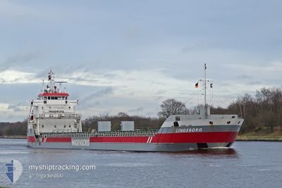
LINGEBORG
General Cargo
Current Trip
| Time Travelled | 7 days |
|---|---|
| Remaining Time | 1 h, 45 mins |
| Distance Travelled | 845.63 nm |
| Remaining Distance | 22.16 nm |
| AVG Speed | 9.6 Knopen |
| MAX Speed | 13.4 Knopen |
| AVG Wind | 16 knots |
| MAX Wind | 27.5 knots |
| MIN Temp | 3.3°C / 37.94°F |
| MAX Temp | 7°C / 44.6°F |
| Diepgang | 5.3 M |
| Positie ontvangen | 1 m geleden |
Current Position
| Lengtegraad | 5.21860° |
|---|---|
| Breedtegraat | 59.47776° |
| Status | Under way using engine |
| Snelheid | 11.3 Knopen |
| Koers | 351.9° |
| Gebied | North Sea |
| Station | T-AIS |
| Positie ontvangen | 1 m geleden |
Info
Information
The current position of LINGEBORG is in North Sea with coordinates 59.47776° / 5.21860° as reported on 2025-03-18 06:00 by AIS to our vessel tracker app. The vessel's current speed is 11.3 Knopen and is heading at the port of STORD. The estimated time of arrival as calculated by MyShipTracking vessel tracking app is 2025-03-18 07:46 LT
The vessel LINGEBORG (IMO: 9399399, MMSI: 245046000) is a General Cargo that was built in 2007 ( 18 Jaar oud ). It's sailing under the flag of [NL] Netherlands.
In this page you can find informations about the vessels current position, last detected port calls, and current voyage information. If the vessels is not in coverage by AIS you will find the latest position.
The current position of LINGEBORG is detected by our AIS receivers and we are not responsible for the reliability of the data. The last position was recorded while the vessel was in Coverage by the Ais receivers of our vessel tracking app.
The current draught of LINGEBORG as reported by AIS is 5.3 meters
Weather
| Temperature | 4.6°C / 40.28°F |
|---|---|
| Wind Speed | 10 knots |
| Direction | 337° NNW |
| Pressure | 1028.6 hPa |
| Humidity | 89.5 % |
| Cloud Coverage | 100 % |
Featured Company
Last Port Calls
| Port | Arrival | Departure | Time In Port |
|---|---|---|---|
| 2025-03-09 10:30 | 2025-03-10 17:03 | 1 d | |
| 2025-03-01 14:38 | 2025-03-02 21:09 | 1 d | |
| 2025-02-21 11:03 | 2025-02-22 11:15 | 1 d | |
| 2025-02-15 06:27 | 2025-02-15 22:32 | 16 h | |
| 2025-01-27 03:10 | 2025-01-27 22:01 | 18 h | |
| 2025-01-09 04:23 | 2025-01-14 10:05 | 5 d | |
| 2025-01-05 05:11 | 2025-01-08 22:53 | 3 d |
Most Visited Ports (Last year)
| Port | Arrivals | |
|---|---|---|
| 5 | ||
| 4 | ||
| 3 | ||
| 3 | ||
| 3 | ||
| 2 |
Last Trips
| Origin | Departure | Destination | Arrival | Distance | |
|---|---|---|---|---|---|
| 2025-03-02 22:09 | 2025-03-09 11:30 | 806.73 nm | |||
| 2025-02-22 12:15 | 2025-03-01 15:38 | 799.23 nm | |||
| 2025-02-15 23:32 | 2025-02-21 12:03 | 791.86 nm | |||
| 2025-01-27 23:01 | 2025-02-15 07:27 | 789.95 nm | |||
| 2025-01-14 11:05 | 2025-01-27 04:10 | 1116.81 nm | |||
| 2025-01-08 23:53 | 2025-01-09 05:23 | 55.59 nm | |||
| 2024-12-24 09:27 | 2025-01-05 06:11 | 1626.25 nm |
Events
| Tijd | Evenement | Details | Positie / Bestemming | Info |
|---|---|---|---|---|
| 2025-03-17 18:10 | Status Changed | Under way using engine Default |
57.58135 / 3.89418
NOSRP
|
Snelheid: 10.6 kn Koers: 34° |
| 2025-03-17 18:10 | Binnenbereik |
57.58135 / 3.89418
North Sea
NOSRP
|
Snelheid: 10.6 kn Koers: 29.8° |
|
| 2025-03-17 16:49 | Status Changed | Default Under way using engine |
57.37854 / 3.67124
NOSRP
|
Snelheid: 10 kn Koers: 24.2° |
| 2025-03-17 16:36 | Buitenbereik |
57.34709 / 3.63891
North Sea
NOSRP
|
Snelheid: 10 kn Koers: 24.2° |
|
| 2025-03-17 16:08 | Gevonden in zee | Norwegian part of the North Sea |
57.27873 / 3.56787
North Sea
NOSRP
|
Snelheid: 10.5 kn Koers: 29.1° |
| 2025-03-17 16:08 | Status Changed | Under way using engine Default |
57.27873 / 3.56787
NOSRP
|
Snelheid: 10.2 kn Koers: 32° |
| 2025-03-17 16:08 | Binnenbereik |
57.27873 / 3.56787
North Sea
NOSRP
|
Snelheid: 10.5 kn Koers: 29.1° |
|
| 2025-03-16 17:34 | Status Changed | Default Under way using engine |
54.82266 / -.83767
NOSRP
|
Snelheid: 9.2 kn Koers: 50.8° |
| 2025-03-16 17:26 | Buitenbereik |
54.81009 / -.86445
North Sea
NOSRP
|
Snelheid: 9.2 kn Koers: 50.8° |
|
| 2025-03-16 17:12 | Status Changed | Under way using engine Default |
54.78750 / -.91317
NOSRP
|
Snelheid: 9.3 kn Koers: 52° |