

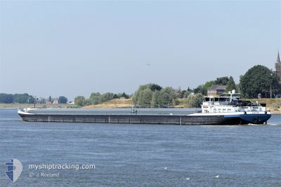
LUTIN
Cargo

Current Trip
| Time Travelled | 2 days |
|---|---|
| Remaining Time | 10 h, 47 mins |
| Distance Travelled | 160.90 nm |
| Remaining Distance | 131.07 nm |
| AVG Speed | 7.7 Knopen |
| MAX Speed | 10.2 Knopen |
| AVG Wind | 4.7 knots |
| MAX Wind | 8.9 knots |
| MIN Temp | 5.8°C / 42.44°F |
| MAX Temp | 20.9°C / 69.62°F |
| Diepgang | 2.2 M |
| Positie ontvangen | 2 h, 48 m geleden |
Current Position
| Lengtegraad | 6.64988° |
|---|---|
| Breedtegraat | 51.57734° |
| Status | Under way using engine |
| Snelheid | 9.2 Knopen |
| Koers | 250.7° |
| Gebied | North Sea |
| Station | T-AIS |
| Positie ontvangen | 2 h, 48 m geleden |
Information
The current position of LUTIN is in North Sea with coordinates 51.57734° / 6.64988° as reported on 2025-05-22 01:21 by AIS to our vessel tracker app. The vessel's current speed is 9.2 Knopen and is heading at the port of ANTWERP. The estimated time of arrival as calculated by MyShipTracking vessel tracking app is 2025-05-22 16:56 LT
The vessel LUTIN (MMSI: 244620704) is a Cargo It's sailing under the flag of [NL] Netherlands.
In this page you can find informations about the vessels current position, last detected port calls, and current voyage information. If the vessels is not in coverage by AIS you will find the latest position.
The current position of LUTIN is detected by our AIS receivers and we are not responsible for the reliability of the data. The last position was recorded while the vessel was in Coverage by the Ais receivers of our vessel tracking app.
The current draught of LUTIN as reported by AIS is 2.2 meters
Weather
| Temperature | 5.9°C / 42.62°F |
|---|---|
| Wind Speed | 5 knots |
| Direction | 336° NNW |
| Pressure | 1013.1 hPa |
| Humidity | 94.3 % |
| Cloud Coverage | 53 % |


Featured Company
Last Port Calls
| Port | Arrival | Departure | Time In Port |
|---|---|---|---|
| 2025-05-17 08:30 | 2025-05-20 02:02 | 2 d | |
| 2025-05-10 21:32 | 2025-05-11 09:13 | 11 h | |
| 2025-05-09 00:25 | 2025-05-10 19:11 | 1 d | |
| 2025-04-27 13:17 | 2025-04-27 14:32 | 1 h | |
| 2025-04-26 20:51 | 2025-04-27 12:49 | 15 h | |
| 2025-04-25 23:15 | 2025-04-26 09:14 | 9 h | |
| 2025-04-23 16:53 | 2025-04-25 12:34 | 1 d | |
| 2025-04-21 19:08 | |||
| 2025-04-16 09:34 | 2025-04-16 10:28 | 53 m | |
| 2025-04-16 08:15 | 2025-04-16 08:42 | 26 m |
Most Visited Ports (Last year)
| Port | Arrivals | |
|---|---|---|
| 35 | ||
| 20 | ||
| 12 | ||
| 12 | ||
| 11 | ||
| 9 |
Last Trips
| Origin | Departure | Destination | Arrival | Distance | |
|---|---|---|---|---|---|
| 2025-05-11 09:13 | 2025-05-17 08:30 | 158.20 nm | |||
| 2025-05-10 19:11 | 2025-05-10 21:32 | 26.85 nm | |||
| 2025-04-27 14:32 | 2025-05-09 00:25 | 543.00 nm | |||
| 2025-04-27 12:49 | 2025-04-27 13:17 | 2.74 nm | |||
| 2025-04-26 09:14 | 2025-04-26 20:51 | 42.50 nm | |||
| 2025-04-25 12:34 | 2025-04-25 23:15 | 79.85 nm | |||
| 2025-04-21 19:08 | 2025-04-23 16:53 | 221.56 nm | |||
| 2025-04-16 08:42 | 2025-04-16 09:34 | 4.35 nm | |||
| 2025-04-15 15:31 | 2025-04-16 08:15 | 87.02 nm | |||
| 2025-04-15 06:19 | 2025-04-15 06:49 | 4.02 nm |
Events
| Tijd | Evenement | Details | Positie / Bestemming | Info |
|---|---|---|---|---|
| 2025-05-22 01:21 | Buitenbereik |
51.57734 / 6.64988
North Sea
CHURCHILLDOK
|
Snelheid: 9.2 kn Koers: 250.7° |
|
| 2025-05-21 15:45 | Draught Changed | 2.2 1.3 |
50.62935 / 7.21212
CHURCHILLDOK
|
Snelheid: 8.8 kn Koers: 358.5° |
| 2025-05-21 15:45 | Destination Changed | CHURCHILLDOK RHEINHAFEN ANDERNACH |
50.62935 / 7.21212
CHURCHILLDOK
|
Snelheid: 8.8 kn Koers: 358.5° |
| 2025-05-21 15:45 | ETA Changed | 2025/05/23 04:00 2025/05/20 15:39 |
50.62935 / 7.21212
CHURCHILLDOK
|
Snelheid: 8.8 kn Koers: 358.5° |
| 2025-05-21 14:54 | Binnenbereik |
50.52736 / 7.29355
North Sea
|
Snelheid: 9.3 kn Koers: 342.2° |
|
| 2025-05-20 11:15 | Buitenbereik |
50.50259 / 7.31256
North Sea
RHEINHAFEN ANDERNACH
|
Snelheid: 6.3 kn Koers: 135° |
|
| 2025-05-20 00:45 | ETA Changed | 2025/05/20 15:39 2025/05/20 06:43 |
51.18481 / 6.76813
RHEINHAFEN ANDERNACH
|
Snelheid: 6.1 kn Koers: 66.5° |
| 2025-05-20 00:02 | Vertrekhaven |
|
51.22519 / 6.71898
RHEINHAFEN ANDERNACH
|
Snelheid: 5.5 kn Koers: 38° |
| 2025-05-19 23:46 | Start beweging |
51.21116 / 6.69280
[DE] NEUSS
|
Snelheid: 4.6 kn Koers: 20° |
|
| 2025-05-19 23:41 | Stop beweging |
51.20937 / 6.69383
[DE] NEUSS
|
Snelheid: 0.2 kn Koers: 312° |