

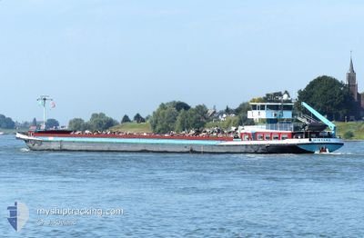
MIRYANA
Cargo

Current Trip
| Time Travelled | 18 h, 54 mins |
|---|---|
| Remaining Time | --- |
| Distance Travelled | 21.51 nm |
| Remaining Distance | --- |
| AVG Speed | 6.9 Knopen |
| MAX Speed | 8.9 Knopen |
| AVG Wind | 13.9 knots |
| MAX Wind | 16 knots |
| MIN Temp | 13.8°C / 56.84°F |
| MAX Temp | 17.3°C / 63.14°F |
| Diepgang | 1.8 M |
| Positie ontvangen | 1 m geleden |
Current Position
| Lengtegraad | 5.43635° |
|---|---|
| Breedtegraat | 52.53611° |
| Status | Moored |
| Snelheid | |
| Koers | --- |
| Gebied | North Sea |
| Station | T-AIS |
| Positie ontvangen | 1 m geleden |
Information
The current position of MIRYANA is in North Sea with coordinates 52.53611° / 5.43635° as reported on 2025-06-07 09:17 by AIS to our vessel tracker app. The vessel's current speed is 0 Knopen and is heading at the port of ENSCHEDE. The estimated time of arrival as calculated by MyShipTracking vessel tracking app is 2025-06-07 17:14 LT
The vessel MIRYANA (IMO: 2321599, MMSI: 244110172) is a Cargo It's sailing under the flag of [NL] Netherlands.
In this page you can find informations about the vessels current position, last detected port calls, and current voyage information. If the vessels is not in coverage by AIS you will find the latest position.
The current position of MIRYANA is detected by our AIS receivers and we are not responsible for the reliability of the data. The last position was recorded while the vessel was in Coverage by the Ais receivers of our vessel tracking app.
The current draught of MIRYANA as reported by AIS is 1.8 meters
Weather
| Temperature | 11.8°C / 53.24°F |
|---|---|
| Wind Speed | 11 knots |
| Direction | 195° SSW |
| Pressure | 1006.3 hPa |
| Humidity | 90.9 % |
| Cloud Coverage | 100 % |


Featured Company
Last Port Calls
| Port | Arrival | Departure | Time In Port |
|---|---|---|---|
| 2025-06-05 18:52 | 2025-06-06 16:24 | 21 h | |
| 2025-06-05 17:37 | 2025-06-05 18:14 | 37 m | |
| 2025-05-21 21:14 | 2025-05-22 05:20 | 8 h | |
| 2025-05-19 21:26 | 2025-05-21 13:34 | 1 d | |
| 2025-05-17 09:13 | |||
| 2025-04-11 21:15 | 2025-04-11 21:29 | 14 m | |
| 2025-04-10 22:25 | 2025-04-11 13:18 | 14 h | |
| 2025-04-09 18:50 | 2025-04-10 17:14 | 22 h | |
| 2025-04-09 11:17 | 2025-04-09 17:01 | 5 h | |
| 2025-04-08 22:18 | 2025-04-09 07:07 | 8 h |
Last Trips
| Origin | Departure | Destination | Arrival | Distance | |
|---|---|---|---|---|---|
| 2025-06-05 18:14 | 2025-06-05 18:52 | 3.10 nm | |||
| 2025-05-22 05:20 | 2025-06-05 17:37 | 67.39 nm | |||
| 2025-05-21 13:34 | 2025-05-21 21:14 | 41.32 nm | |||
| 2025-05-17 09:13 | 2025-05-19 21:26 | 62.99 nm | |||
| 2025-04-11 13:18 | 2025-04-11 21:15 | 44.41 nm | |||
| 2025-04-10 17:14 | 2025-04-10 22:25 | 28.94 nm | |||
| 2025-04-09 17:01 | 2025-04-09 18:50 | 12.05 nm | |||
| 2025-04-09 07:07 | 2025-04-09 11:17 | 32.75 nm | |||
| 2025-03-11 13:33 | 2025-04-08 22:18 | 160.30 nm |
Events
| Tijd | Evenement | Details | Positie / Bestemming | Info |
|---|---|---|---|---|
| 2025-06-06 18:11 | Status Changed | Moored Under way using engine |
52.53611 / 5.43637
ENSCHEDE
|
Snelheid: Koers: 511° |
| 2025-06-06 17:52 | Stop beweging | 0.6 nm, North of LELYSTAD |
52.53614 / 5.43642
ENSCHEDE
|
Snelheid: Koers: 511° |
| 2025-06-06 17:46 | Start beweging | 0.28 nm, North West of LELYSTAD |
52.52989 / 5.43418
ENSCHEDE
|
Snelheid: 3.8 kn Koers: 10.9° |
| 2025-06-06 17:20 | Stop beweging | 0.17 nm, North West of LELYSTAD |
52.52741 / 5.43467
ENSCHEDE
|
Snelheid: Koers: 511° |
| 2025-06-06 14:44 | Start beweging | 0.17 nm, South West of SCHELLINGWOUDE |
52.37990 / 4.96042
ENSCHEDE
|
Snelheid: 4.1 kn Koers: 113.5° |
| 2025-06-06 14:27 | Stop beweging | 0.3 nm, West of SCHELLINGWOUDE |
52.38167 / 4.95660
ENSCHEDE
|
Snelheid: Koers: 511° |
| 2025-06-06 14:24 | Vertrekhaven |
|
52.38154 / 4.95430
ENSCHEDE
|
Snelheid: 3.3 kn Koers: 94.8° |
| 2025-06-06 13:33 | Destination Changed | ENSCHEDE RIETLANDEN KADE AMST |
52.42037 / 4.81320
[NL] AMSTERDAM
|
Snelheid: 6 kn Koers: 24.6° |
| 2025-06-06 13:33 | ETA Changed | 2025/06/07 15:14 2025/06/05 04:35 |
52.42037 / 4.81320
[NL] AMSTERDAM
|
Snelheid: 6 kn Koers: 24.6° |
| 2025-06-06 13:20 | Start beweging |
52.40154 / 4.82304
[NL] AMSTERDAM
|
Snelheid: 3.1 kn Koers: 280.5° |