

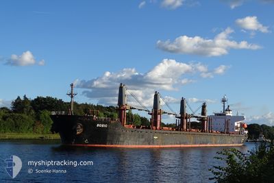
MV BOBIC
Bulk Carrier

Current Trip
| Trip Time | 8 days |
|---|---|
| Trip Distance | 1535.63 nm |
| AVG Speed | 10.8 Knopen |
| MAX Speed | 13.7 Knopen |
| Diepgang | 9.9 M |
| AVG Wind | 8.6 knots |
| MAX Wind | 23.8 knots |
| MIN Temp | 13.8°C / 56.84°F |
| MAX Temp | 27°C / 80.6°F |
| Positie ontvangen | 5 d geleden |
Current Position
| Lengtegraad | 10.85127° |
|---|---|
| Breedtegraat | 34.67770° |
| Status | At anchor |
| Snelheid | 0.1 Knopen |
| Koers | 84° |
| Gebied | Mediterranean Sea - Eastern Basin |
| Station | T-AIS |
| Positie ontvangen | 5 d geleden |
Information
The current position of MV BOBIC is in Mediterranean Sea - Eastern Basin with coordinates 34.67770° / 10.85127° as reported on 2025-05-26 20:20 by AIS to our vessel tracker app. The vessel's current speed is 0.1 Knopen and is currently inside the port of SFAX.
The vessel MV BOBIC (IMO: 9317781, MMSI: 538006462) is a Bulk Carrier that was built in 2006 ( 19 Jaar oud ). It's sailing under the flag of [MH] Marshall Is.
In this page you can find informations about the vessels current position, last detected port calls, and current voyage information. If the vessels is not in coverage by AIS you will find the latest position.
The current position of MV BOBIC is detected by our AIS receivers and we are not responsible for the reliability of the data. The last position was recorded while the vessel was in Coverage by the Ais receivers of our vessel tracking app.
The current draught of MV BOBIC as reported by AIS is 9.9 meters
Weather
| Temperature | 21.2°C / 70.16°F |
|---|---|
| Wind Speed | 2 knots |
| Direction | 23° NNE |
| Pressure | 1019.9 hPa |
| Humidity | 51.6 % |
| Cloud Coverage | 1 % |


Featured Company
Events
| Tijd | Evenement | Details | Positie / Bestemming | Info |
|---|---|---|---|---|
| 2025-05-27 16:11 | Stop beweging |
34.72803 / 10.76658
[TN] SFAX
|
Snelheid: 0.2 kn Koers: 45° |
|
| 2025-05-27 15:46 | Aankomsthaven |
|
34.72035 / 10.77820
[TN] SFAX
|
Snelheid: 4.7 kn Koers: 320° |
| 2025-05-27 14:54 | Start beweging | 4.33 nm, South East of SFAX |
34.67688 / 10.84560
TN SFA
|
Snelheid: 4.1 kn Koers: 264° |
| 2025-05-26 20:26 | Status Changed | Default At anchor |
34.67787 / 10.85120
TN SFA
|
Snelheid: 0.1 kn Koers: 84° |
| 2025-05-26 20:20 | Status Changed | At anchor Default |
34.67770 / 10.85127
TN SFA
|
Snelheid: Koers: 76° |
| 2025-05-26 20:20 | Buitenbereik |
34.67770 / 10.85127
Mediterranean Sea - Eastern Basin
|
Snelheid: 0.1 kn Koers: 318° |
|
| 2025-05-26 20:14 | Status Changed | Default At anchor |
34.67755 / 10.85133
TN SFA
|
Snelheid: 0.1 kn Koers: 69° |
| 2025-05-26 20:08 | Wijzig zee gebeid | Tunisian part of the Mediterranean Sea - Eastern Basin Libyan part of the Mediterranean Sea - Eastern Basin |
34.67740 / 10.85140
Mediterranean Sea - Eastern Basin
|
Snelheid: 0.1 kn Koers: 322° |
| 2025-05-26 20:08 | Status Changed | At anchor Default |
34.67740 / 10.85140
TN SFA
|
Snelheid: 0.1 kn Koers: 62° |
| 2025-05-26 19:50 | Binnenbereik |
34.67740 / 10.85140
Mediterranean Sea - Eastern Basin
|
Snelheid: 0.1 kn Koers: 322° |