

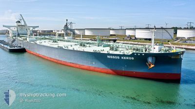
NISSOS KEROS
Tanker

Current Trip
USGLS>SUNGAI LINGGI
| Time Travelled | 49 days |
|---|---|
| Remaining Time | --- |
| Distance Travelled | 10723.19 nm |
| Remaining Distance | --- |
| AVG Speed | 12 Knopen |
| MAX Speed | 15.7 Knopen |
| AVG Wind | 13.9 knots |
| MAX Wind | 35.8 knots |
| MIN Temp | 16.7°C / 62.06°F |
| MAX Temp | 30°C / 86°F |
| Diepgang | 20.7 M |
| Positie ontvangen | 2 d geleden |
Current Position
| Lengtegraad | 100.22335° |
|---|---|
| Breedtegraat | 3.51683° |
| Status | Under way using engine |
| Snelheid | 11.5 Knopen |
| Koers | 135° |
| Gebied | Malacca Strait |
| Station | T-AIS |
| Positie ontvangen | 2 d geleden |
Information
The current position of NISSOS KEROS is in Malacca Strait with coordinates 3.51683° / 100.22335° as reported on 2025-06-06 10:53 by AIS to our vessel tracker app. The vessel's current speed is 11.5 Knopen
The vessel NISSOS KEROS (IMO: 9856074, MMSI: 538008311) is a Tanker It's sailing under the flag of [MH] Marshall Is.
In this page you can find informations about the vessels current position, last detected port calls, and current voyage information. If the vessels is not in coverage by AIS you will find the latest position.
The current position of NISSOS KEROS is detected by our AIS receivers and we are not responsible for the reliability of the data. The last position was recorded while the vessel was in Coverage by the Ais receivers of our vessel tracking app.
The current draught of NISSOS KEROS as reported by AIS is 20.7 meters
Weather
| Temperature | 28.4°C / 83.12°F |
|---|---|
| Wind Speed | 8 knots |
| Direction | 239° WSW |
| Pressure | 1007.6 hPa |
| Humidity | 75.1 % |
| Cloud Coverage | 70 % |


Featured Company
Most Visited Ports (Last year)
| Port | Arrivals | |
|---|---|---|
| 3 | ||
| 1 | ||
| 1 | ||
| 1 | ||
| 1 | ||
| 1 |
Last Trips
| Origin | Departure | Destination | Arrival | Distance | |
|---|---|---|---|---|---|
| 2025-02-07 19:01 | 2025-04-18 16:48 | 4877.65 nm |
Events
| Tijd | Evenement | Details | Positie / Bestemming | Info |
|---|---|---|---|---|
| 2025-06-08 20:35 | Start beweging | 7.91 nm, North West of SUNGAI UDANG |
2.29805 / 102.00754
USGLS>SUNGAI LINGGI
|
Snelheid: 3.7 kn Koers: 240° |
| 2025-06-07 03:03 | Stop beweging | 7.89 nm, North West of SUNGAI UDANG |
2.30465 / 102.01105
USGLS>SUNGAI LINGGI
|
Snelheid: 0.3 kn Koers: 144° |
| 2025-06-06 10:55 | Status Changed | Default Under way using engine |
3.51068 / 100.22933
USGLS>SUNGAI LINGGI
|
Snelheid: 11.5 kn Koers: 135° |
| 2025-06-06 10:53 | Status Changed | Under way using engine Default |
3.51683 / 100.22335
USGLS>SUNGAI LINGGI
|
Snelheid: 11.5 kn Koers: 136° |
| 2025-06-06 10:53 | Buitenbereik |
3.51683 / 100.22335
Malacca Strait
|
Snelheid: 11.5 kn Koers: 135° |
|
| 2025-06-06 10:47 | Status Changed | Default Under way using engine |
3.53001 / 100.21088
USGLS>SUNGAI LINGGI
|
Snelheid: 11.5 kn Koers: 136.9° |
| 2025-06-06 10:39 | Gevonden in zee | Indonesian part of the Malacca Strait |
3.54781 / 100.19416
Malacca Strait
|
Snelheid: 11.5 kn Koers: 136.2° |
| 2025-06-06 10:39 | Status Changed | Under way using engine Default |
3.54820 / 100.19379
USGLS>SUNGAI LINGGI
|
Snelheid: 11.5 kn Koers: 136° |
| 2025-06-06 10:22 | Binnenbereik |
3.54781 / 100.19416
Malacca Strait
|
Snelheid: 11.5 kn Koers: 136.2° |