
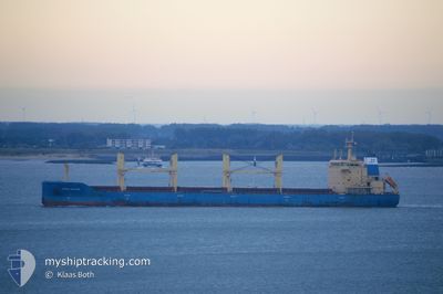
NORDIC MALMOE
Bulk Carrier
Current Trip
| Time Travelled | 50 days |
|---|---|
| Remaining Time | 4 days |
| Distance Travelled | 6613.15 nm |
| Remaining Distance | 1295.60 nm |
| AVG Speed | 10.4 Knopen |
| MAX Speed | 13.4 Knopen |
| AVG Wind | 9.8 knots |
| MAX Wind | 31.8 knots |
| MIN Temp | 18.3°C / 64.94°F |
| MAX Temp | 29.9°C / 85.82°F |
| Diepgang | 9.3 M |
| Positie ontvangen | 11 h, 40 m geleden |
Current Position
| Lengtegraad | 17.85954° |
|---|---|
| Breedtegraat | -34.10025° |
| Status | Under way using engine |
| Snelheid | 11.1 Knopen |
| Koers | 336.8° |
| Gebied | South Atlantic Ocean |
| Station | T-AIS |
| Positie ontvangen | 11 h, 40 m geleden |
Info
Information
The current position of NORDIC MALMOE is in South Atlantic Ocean with coordinates -34.10025° / 17.85954° as reported on 2025-03-11 22:33 by AIS to our vessel tracker app. The vessel's current speed is 11.1 Knopen and is heading at the port of LOBITO. The estimated time of arrival as calculated by MyShipTracking vessel tracking app is 2025-03-17 07:52 LT
The vessel NORDIC MALMOE (IMO: 9602679, MMSI: 636092675) is a Bulk Carrier that was built in 2012 ( 13 Jaar oud ). It's sailing under the flag of [LR] Liberia.
In this page you can find informations about the vessels current position, last detected port calls, and current voyage information. If the vessels is not in coverage by AIS you will find the latest position.
The current position of NORDIC MALMOE is detected by our AIS receivers and we are not responsible for the reliability of the data. The last position was recorded while the vessel was in Coverage by the Ais receivers of our vessel tracking app.
The current draught of NORDIC MALMOE as reported by AIS is 9.3 meters
Weather
| Temperature | 18.3°C / 64.94°F |
|---|---|
| Wind Speed | 21 knots |
| Direction | 168° SSE |
| Pressure | 1011.6 hPa |
| Humidity | 89.2 % |
| Cloud Coverage | --- |
Featured Company
Most Visited Ports (Last year)
| Port | Arrivals | |
|---|---|---|
| 3 | ||
| 2 | ||
| 2 | ||
| 1 | ||
| 1 | ||
| 1 |
Last Trips
| Origin | Departure | Destination | Arrival | Distance | |
|---|---|---|---|---|---|
| 2025-01-06 10:06 | 2025-01-20 08:41 | 1909.70 nm | |||
| 2024-12-11 15:25 | 2025-01-05 07:12 | 4543.79 nm |
Events
| Tijd | Evenement | Details | Positie / Bestemming | Info |
|---|---|---|---|---|
| 2025-03-11 22:39 | Status Changed | Default Under way using engine |
-34.08492 / 17.85141
AOLOB
|
Snelheid: 11.1 kn Koers: 336.8° |
| 2025-03-11 22:33 | Buitenbereik |
-34.10025 / 17.85954
South Atlantic Ocean
AOLOB
|
Snelheid: 11.1 kn Koers: 336.8° |
|
| 2025-03-11 22:32 | Status Changed | Under way using engine Default |
-34.10499 / 17.86201
AOLOB
|
Snelheid: 11.2 kn Koers: 336° |
| 2025-03-11 22:18 | Status Changed | Default Under way using engine |
-34.14354 / 17.88093
AOLOB
|
Snelheid: 11.1 kn Koers: 343.2° |
| 2025-03-11 22:12 | Status Changed | Under way using engine Default |
-34.16351 / 17.88868
AOLOB
|
Snelheid: 10.9 kn Koers: 340° |
| 2025-03-11 22:07 | Status Changed | Default Under way using engine |
-34.17757 / 17.89435
AOLOB
|
Snelheid: 10.7 kn Koers: 343° |
| 2025-03-11 21:59 | Status Changed | Under way using engine Default |
-34.19928 / 17.90298
AOLOB
|
Snelheid: 10.7 kn Koers: 342° |
| 2025-03-11 21:56 | Status Changed | Default Under way using engine |
-34.20987 / 17.90715
AOLOB
|
Snelheid: 10.8 kn Koers: 339.1° |
| 2025-03-11 21:50 | Status Changed | Under way using engine Default |
-34.22449 / 17.91306
AOLOB
|
Snelheid: 10.8 kn Koers: 340° |
| 2025-03-11 21:35 | Status Changed | Default Under way using engine |
-34.26832 / 17.93088
AOLOB
|
Snelheid: 10.8 kn Koers: 339.7° |