
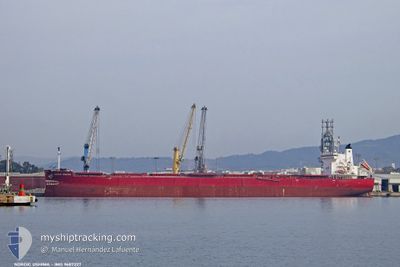
NORDIC OSHIMA
Cargo
Current Trip
| Time Travelled | 1 day |
|---|---|
| Remaining Time | 16 h, 1 mins |
| Distance Travelled | 501.98 nm |
| Remaining Distance | 225.69 nm |
| AVG Speed | 10.9 Knopen |
| MAX Speed | 12.8 Knopen |
| AVG Wind | 9.2 knots |
| MAX Wind | 21 knots |
| MIN Temp | 11.6°C / 52.88°F |
| MAX Temp | 14.8°C / 58.64°F |
| Diepgang | 8.2 M |
| Positie ontvangen | 57 m geleden |
Current Position
| Lengtegraad | -1.51805° |
|---|---|
| Breedtegraat | 36.90019° |
| Status | Under way using engine |
| Snelheid | 10.9 Knopen |
| Koers | 229.5° |
| Gebied | Mediterranean Sea - Western Basin |
| Station | T-AIS |
| Positie ontvangen | 57 m geleden |
Info
Information
The current position of NORDIC OSHIMA is in Mediterranean Sea - Western Basin with coordinates 36.90019° / -1.51805° as reported on 2025-02-21 04:56 by AIS to our vessel tracker app. The vessel's current speed is 10.9 Knopen and is heading at the port of ALGECIRAS. The estimated time of arrival as calculated by MyShipTracking vessel tracking app is 2025-02-21 21:55 LT
The vessel NORDIC OSHIMA (IMO: 9687227, MMSI: 538009300) is a Cargo It's sailing under the flag of [MH] Marshall Is.
In this page you can find informations about the vessels current position, last detected port calls, and current voyage information. If the vessels is not in coverage by AIS you will find the latest position.
The current position of NORDIC OSHIMA is detected by our AIS receivers and we are not responsible for the reliability of the data. The last position was recorded while the vessel was in Coverage by the Ais receivers of our vessel tracking app.
The current draught of NORDIC OSHIMA as reported by AIS is 8.2 meters
Weather
| Temperature | 14.6°C / 58.28°F |
|---|---|
| Wind Speed | 6 knots |
| Direction | 78° ENE |
| Pressure | 1025.7 hPa |
| Humidity | 82 % |
| Cloud Coverage | 3 % |
Featured Company
Last Port Calls
| Port | Arrival | Departure | Time In Port |
|---|---|---|---|
| 2025-02-15 16:29 | 2025-02-19 10:36 | 3 d | |
| 2025-01-17 21:53 | 2025-01-19 00:19 | 1 d | |
| 2025-01-07 06:08 | 2025-01-10 00:10 | 2 d | |
| 2024-12-14 17:20 | 2024-12-15 13:20 | 19 h | |
| 2024-12-01 15:20 |
Most Visited Ports (Last year)
| Port | Arrivals | |
|---|---|---|
| 8 | ||
| 2 | ||
| 2 | ||
| 2 | ||
| 1 | ||
| 1 |
Last Trips
| Origin | Departure | Destination | Arrival | Distance | |
|---|---|---|---|---|---|
| 2025-01-18 19:19 | 2025-02-15 17:29 | 3866.02 nm | |||
| 2025-01-09 19:10 | 2025-01-17 16:53 | 354.66 nm | |||
| 2024-12-15 10:20 | 2025-01-07 01:08 | 4273.46 nm | |||
| 2024-12-01 10:20 | 2024-12-14 14:20 | 3956.88 nm |
Events
| Tijd | Evenement | Details | Positie / Bestemming | Info |
|---|---|---|---|---|
| 2025-02-21 04:59 | Status Changed | Default Under way using engine |
36.89390 / -1.52721
ESALG
|
Snelheid: 10.9 kn Koers: 229.5° |
| 2025-02-21 04:56 | Status Changed | Under way using engine Default |
36.90019 / -1.51805
ESALG
|
Snelheid: 11.1 kn Koers: 229° |
| 2025-02-21 04:50 | Status Changed | Default Under way using engine |
36.91334 / -1.49889
ESALG
|
Snelheid: 11.1 kn Koers: 229.4° |
| 2025-02-21 04:35 | Status Changed | Under way using engine Default |
36.94227 / -1.45617
ESALG
|
Snelheid: 11.1 kn Koers: 229° |
| 2025-02-21 04:24 | Binnenbereik |
36.94227 / -1.45617
Mediterranean Sea - Western Basin
ESALG
|
Snelheid: 11.1 kn Koers: 229.4° |
|
| 2025-02-21 02:19 | Status Changed | Default Under way using engine |
37.23299 / -1.04313
ESALG
|
Snelheid: 11.3 kn Koers: 225.5° |
| 2025-02-21 02:11 | Buitenbereik |
37.25126 / -1.01949
Mediterranean Sea - Western Basin
ESALG
|
Snelheid: 11.3 kn Koers: 225.5° |
|
| 2025-02-21 01:33 | Status Changed | Under way using engine Default |
37.33411 / -.90873
ESALG
|
Snelheid: 11.6 kn Koers: 230° |
| 2025-02-21 01:19 | Status Changed | Default Under way using engine |
37.36214 / -.86661
ESALG
|
Snelheid: 11.9 kn Koers: 231° |
| 2025-02-21 01:08 | Status Changed | Under way using engine Default |
37.38562 / -.83023
ESALG
|
Snelheid: 12.1 kn Koers: 231° |