
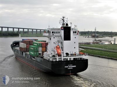
PACIFIC NINGBO
Container Ship
Current Trip
| Time Travelled | 7 h, 40 mins |
|---|---|
| Remaining Time | 5 h, 18 mins |
| Distance Travelled | 69.95 nm |
| Remaining Distance | 156.67 nm |
| AVG Speed | 15.3 Knopen |
| MAX Speed | 16.9 Knopen |
| AVG Wind | 16 knots |
| MAX Wind | 30.3 knots |
| MIN Temp | 11.2°C / 52.16°F |
| MAX Temp | 15.9°C / 60.62°F |
| Diepgang | 8.3 M |
| Positie ontvangen | 4 d geleden |
Current Position
| Lengtegraad | 129.20750° |
|---|---|
| Breedtegraat | 35.05377° |
| Status | Under way using engine |
| Snelheid | 9.4 Knopen |
| Koers | 89.3° |
| Gebied | Japan Sea |
| Station | T-AIS |
| Positie ontvangen | 4 d geleden |
Info
Information
The current position of PACIFIC NINGBO is in Japan Sea with coordinates 35.05377° / 129.20750° as reported on 2025-03-19 23:21 by AIS to our vessel tracker app. The vessel's current speed is 9.4 Knopen and is heading at the port of SAKAIMINATO. The estimated time of arrival as calculated by MyShipTracking vessel tracking app is 2025-03-24 13:59 LT
The vessel PACIFIC NINGBO (IMO: 9339064, MMSI: 563159100) is a Container Ship that was built in 2006 ( 19 Jaar oud ). It's sailing under the flag of [SG] Singapore.
In this page you can find informations about the vessels current position, last detected port calls, and current voyage information. If the vessels is not in coverage by AIS you will find the latest position.
The current position of PACIFIC NINGBO is detected by our AIS receivers and we are not responsible for the reliability of the data. The last position was recorded while the vessel was in Coverage by the Ais receivers of our vessel tracking app.
The current draught of PACIFIC NINGBO as reported by AIS is 8.3 meters
Weather
| Temperature | 11.5°C / 52.7°F |
|---|---|
| Wind Speed | 29 knots |
| Direction | 267° W |
| Pressure | 1006.3 hPa |
| Humidity | 85.7 % |
| Cloud Coverage | 100 % |
Featured Company
Last Port Calls
| Port | Arrival | Departure | Time In Port |
|---|---|---|---|
| 2025-03-22 22:10 | 2025-03-24 01:01 | 1 d | |
| 2025-03-22 01:00 | 2025-03-22 04:46 | 3 h | |
| 2025-03-19 05:40 | 2025-03-19 22:42 | 17 h | |
| 2025-03-18 04:33 | 2025-03-19 03:02 | 22 h | |
| 2025-03-17 02:42 | 2025-03-17 08:30 | 5 h | |
| 2025-03-15 22:33 | 2025-03-16 05:29 | 6 h | |
| 2025-03-14 00:18 | 2025-03-14 08:42 | 8 h | |
| 2025-03-12 09:29 | 2025-03-12 18:05 | 8 h | |
| 2025-03-11 20:27 | 2025-03-12 03:10 | 6 h | |
| 2025-03-11 08:17 | 2025-03-11 17:09 | 8 h |
Most Visited Ports (Last year)
| Port | Arrivals | |
|---|---|---|
| 44 | ||
| 42 | ||
| 39 | ||
| 30 | ||
| 28 | ||
| 10 |
Last Trips
| Origin | Departure | Destination | Arrival | Distance | |
|---|---|---|---|---|---|
| 2025-03-22 13:46 | 2025-03-23 07:10 | 142.45 nm | |||
| 2025-03-20 07:42 | 2025-03-22 10:00 | 274.56 nm | |||
| 2025-03-19 12:02 | 2025-03-19 14:40 | 29.70 nm | |||
| 2025-03-17 17:30 | 2025-03-18 13:33 | 245.72 nm | |||
| 2025-03-16 14:29 | 2025-03-17 11:42 | 120.64 nm | |||
| 2025-03-14 17:42 | 2025-03-16 07:33 | 195.93 nm | |||
| 2025-03-13 03:05 | 2025-03-14 09:18 | 352.44 nm | |||
| 2025-03-12 12:10 | 2025-03-12 18:29 | 37.26 nm | |||
| 2025-03-12 02:09 | 2025-03-12 05:27 | 28.37 nm | |||
| 2025-03-10 16:23 | 2025-03-11 17:17 | 330.25 nm |
Events
| Tijd | Evenement | Details | Positie / Bestemming | Info |
|---|---|---|---|---|
| 2025-03-24 01:01 | Vertrekhaven |
|
35.69854 / 136.06117
JPSMN
|
Snelheid: 13.8 kn Koers: 23° |
| 2025-03-24 00:54 | Start beweging |
35.67159 / 136.05730
[JP] TSURUGA
|
Snelheid: 9.3 kn Koers: 320° |
|
| 2025-03-22 22:30 | Stop beweging |
35.66834 / 136.06395
[JP] TSURUGA
|
Snelheid: Koers: 88° |
|
| 2025-03-22 22:10 | Aankomsthaven |
|
35.68833 / 136.05441
[JP] TSURUGA
|
Snelheid: 6.8 kn Koers: 196° |
| 2025-03-22 04:46 | Vertrekhaven |
|
35.55243 / 133.27911
JPSMN
|
Snelheid: 8.2 kn Koers: 45° |
| 2025-03-22 04:38 | Start beweging |
35.54146 / 133.26297
[JP] SAKAIMINATO
|
Snelheid: 5.4 kn Koers: 40° |
|
| 2025-03-22 01:00 | Stop beweging |
35.54123 / 133.25816
[JP] SAKAIMINATO
|
Snelheid: Koers: 237° |
|
| 2025-03-22 01:00 | Aankomsthaven |
|
35.54123 / 133.25816
[JP] SAKAIMINATO
|
Snelheid: 5.9 kn Koers: 249° |
| 2025-03-22 00:18 | Start beweging | 1.57 nm, South of MIHONOSEKI |
35.53413 / 133.31184
JPSMN
|
Snelheid: 5.6 kn Koers: 312° |
| 2025-03-21 08:58 | Stop beweging | 1.67 nm, South of MIHONOSEKI |
35.53292 / 133.31599
JPSMN
|
Snelheid: 0.1 kn Koers: 234° |