
RIZABEY
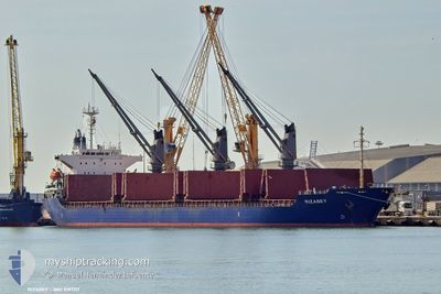
Bulk Carrier
Current Trip
| Time Travelled | 1 day |
|---|---|
| Remaining Time | 1 day |
| Distance Travelled | 244.15 nm |
| Remaining Distance | 239.82 nm |
| AVG Speed | 10.1 Knopen |
| MAX Speed | 11.5 Knopen |
| AVG Wind | 14.3 knots |
| MAX Wind | 25 knots |
| MIN Temp | 13.7°C / 56.66°F |
| MAX Temp | 16°C / 60.8°F |
| Diepgang | 8.9 M |
| Positie ontvangen | 1 m geleden |
Current Position
| Lengtegraad | -5.31070° |
|---|---|
| Breedtegraat | 36.08650° |
| Status | Under way using engine |
| Snelheid | 2.5 Knopen |
| Koers | 282° |
| Gebied | Alboran Sea |
| Station | T-AIS |
| Positie ontvangen | 1 m geleden |
Info
Information
The current position of RIZABEY is in Alboran Sea with coordinates 36.08650° / -5.31070° as reported on 2026-01-10 19:13 by AIS to our vessel tracker app. The vessel's current speed is 2.5 Knopen and is heading at the port of CARTAGENA. The estimated time of arrival as calculated by MyShipTracking vessel tracking app is 2026-01-12 01:30 LT
The vessel RIZABEY (IMO: 9197117, MMSI: 352001807) is a Bulk Carrier that was built in 1999 ( 27 Jaar oud ). It's sailing under the flag of [PA] Panama.
In this page you can find informations about the vessels current position, last detected port calls, and current voyage information. If the vessels is not in coverage by AIS you will find the latest position.
The current position of RIZABEY is detected by our AIS receivers and we are not responsible for the reliability of the data. The last position was recorded while the vessel was in Coverage by the Ais receivers of our vessel tracking app.
The current draught of RIZABEY as reported by AIS is 8.9 meters
Weather
| Temperature | 13.6°C / 56.48°F |
|---|---|
| Wind Speed | 15 knots |
| Direction | 276° W |
| Pressure | 1027.2 hPa |
| Humidity | 69.4 % |
| Cloud Coverage | 36 % |
Featured Company
Last Port Calls
| Port | Arrival | Departure | Time In Port |
|---|---|---|---|
| 2026-01-03 14:50 | 2026-01-09 19:45 | 6 d | |
| 2025-12-23 16:19 | 2025-12-25 16:43 | 2 d | |
| 2025-12-17 11:22 | 2025-12-17 20:30 | 9 h | |
| 2025-11-05 18:02 |
Events
| Tijd | Evenement | Details | Positie / Bestemming | Info |
|---|---|---|---|---|
| 2026-01-10 18:45 | Start beweging | 7.01 nm, South East of GIBRALTAR |
36.07735 / -5.24717
GI GIB
|
Snelheid: 3.8 kn Koers: 276° |
| 2026-01-10 18:44 | Draught Changed | 8.9 9 |
36.07728 / -5.24575
GI GIB
|
Snelheid: 2.7 kn Koers: 276° |
| 2026-01-10 18:44 | Destination Changed | GI GIB ES CAR |
36.07728 / -5.24575
GI GIB
|
Snelheid: 2.7 kn Koers: 276° |
| 2026-01-10 18:44 | ETA Changed | 2026/01/10 19:00 |
36.07728 / -5.24575
GI GIB
|
Snelheid: 2.7 kn Koers: 276° |
| 2026-01-10 18:36 | Status Changed | Under way using engine Default |
36.08088 / -5.24582
ES CAR
|
Snelheid: 2.2 kn Koers: 212° |
| 2026-01-10 18:09 | Stop beweging | 6.2 nm, South East of GIBRALTAR |
36.08425 / -5.26163
ES CAR
|
Snelheid: 0.2 kn Koers: 263° |
| 2026-01-10 18:00 | Status Changed | Default Under way using engine |
36.08508 / -5.25795
ES CAR
|
Snelheid: 6.3 kn Koers: 264° |
| 2026-01-10 17:55 | Status Changed | Under way using engine Default |
36.08573 / -5.25008
ES CAR
|
Snelheid: 7 kn Koers: 264° |
| 2026-01-10 17:49 | Status Changed | Default Under way using engine |
36.08730 / -5.23265
ES CAR
|
Snelheid: 8.8 kn Koers: 260° |
| 2026-01-10 17:45 | Wijzig zee gebeid | Gibraltarian part of the Alboran Sea Spanish part of the Mediterranean Sea - Western Basin |
36.08907 / -5.21913
Alboran Sea
|
Snelheid: 8.8 kn Koers: 260° |