

SANTIAGO
Not available
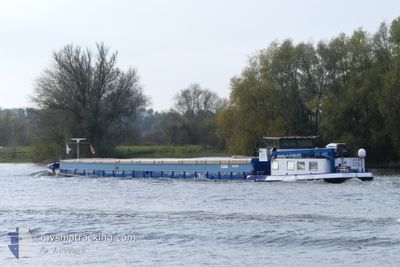

Current Trip
Unknown
| Time Travelled | 8 days |
|---|---|
| Remaining Time | --- |
| Distance Travelled | 84.52 nm |
| Remaining Distance | --- |
| AVG Speed | 6.1 Knopen |
| MAX Speed | 7.9 Knopen |
| AVG Wind | 4.7 knots |
| MAX Wind | 8.9 knots |
| MIN Temp | 7.6°C / 45.68°F |
| MAX Temp | 19.2°C / 66.56°F |
| Diepgang | 0.3 M |
| Positie ontvangen | 6 d geleden |
Current Position
| Lengtegraad | 5.68949° |
|---|---|
| Breedtegraat | 50.79015° |
| Status | Under way using engine |
| Snelheid | 7 Knopen |
| Koers | 184.3° |
| Gebied | North Sea |
| Station | T-AIS |
| Positie ontvangen | 6 d geleden |
Information
The current position of SANTIAGO is in North Sea with coordinates 50.79015° / 5.68949° as reported on 2025-05-21 19:11 by AIS to our vessel tracker app. The vessel's current speed is 7 Knopen
The vessel SANTIAGO (MMSI: 244750586) is a Not available It's sailing under the flag of [NL] Netherlands.
In this page you can find informations about the vessels current position, last detected port calls, and current voyage information. If the vessels is not in coverage by AIS you will find the latest position.
The current position of SANTIAGO is detected by our AIS receivers and we are not responsible for the reliability of the data. The last position was recorded while the vessel was in Coverage by the Ais receivers of our vessel tracking app.
The current draught of SANTIAGO as reported by AIS is 0.3 meters
Weather
| Temperature | 11.8°C / 53.24°F |
|---|---|
| Wind Speed | 2 knots |
| Direction | 339° NNW |
| Pressure | 1012.6 hPa |
| Humidity | 83.7 % |
| Cloud Coverage | 100 % |


Featured Company
Last Port Calls
| Port | Arrival | Departure | Time In Port |
|---|---|---|---|
| 2025-05-19 23:34 | 2025-05-20 05:29 | 5 h | |
| 2025-05-19 09:21 | 2025-05-19 19:21 | 10 h | |
| 2025-05-15 13:02 | 2025-05-19 09:06 | 3 d | |
| 2025-05-08 21:25 | |||
| 2025-04-28 09:41 | 2025-04-29 09:13 | 23 h | |
| 2025-04-25 13:20 | 2025-04-25 14:19 | 59 m | |
| 2025-04-22 13:01 | 2025-04-23 09:11 | 20 h | |
| 2025-04-18 20:09 | 2025-04-22 11:05 | 3 d | |
| 2025-04-17 11:35 | |||
| 2025-04-08 07:52 | 2025-04-08 08:21 | 29 m |
Last Trips
| Origin | Departure | Destination | Arrival | Distance | |
|---|---|---|---|---|---|
| 2025-05-19 19:21 | 2025-05-19 23:34 | 30.97 nm | |||
| 2025-05-19 09:06 | 2025-05-19 09:21 | 0.97 nm | |||
| 2025-04-29 09:13 | 2025-05-08 21:25 | 218.14 nm | |||
| 2025-04-25 14:19 | 2025-04-28 09:41 | 30.13 nm | |||
| 2025-04-23 09:11 | 2025-04-25 13:20 | 145.00 nm | |||
| 2025-04-22 11:05 | 2025-04-22 13:01 | 16.85 nm | |||
| 2025-04-08 08:21 | 2025-04-17 11:35 | 191.92 nm | |||
| 2025-04-07 12:50 | 2025-04-08 07:52 | 18.91 nm | |||
| 2025-04-03 11:53 | 2025-04-06 18:30 | 0.66 nm | |||
| 2025-04-02 13:14 | 2025-04-02 16:43 | 2.42 nm |
Events
| Tijd | Evenement | Details | Positie / Bestemming | Info |
|---|---|---|---|---|
| 2025-05-21 19:11 | Buitenbereik |
50.79015 / 5.68949
North Sea
|
Snelheid: 7 kn Koers: 184.3° |
|
| 2025-05-21 18:45 | Binnenbereik |
50.79838 / 5.69033
North Sea
|
Snelheid: 3.5 kn Koers: 184.1° |
|
| 2025-05-21 16:42 | Buitenbereik |
50.99793 / 5.77183
North Sea
|
Snelheid: 7.5 kn Koers: 189.6° |
|
| 2025-05-21 16:24 | Start beweging | 1.93 nm, South of BARGE TERMINAL BORN |
51.03029 / 5.79577
|
Snelheid: 5.1 kn Koers: 210.9° |
| 2025-05-21 16:17 | Binnenbereik |
51.03475 / 5.79837
North Sea
|
Snelheid: Koers: 41.8° |
|
| 2025-05-21 04:53 | Buitenbereik |
51.75104 / 5.87744
North Sea
|
Snelheid: 7.8 kn Koers: 143.5° |
|
| 2025-05-21 03:48 | Start beweging | 0.25 nm, West of NIJMEGEN |
51.84799 / 5.81724
|
Snelheid: 3.8 kn Koers: 202.2° |
| 2025-05-20 07:02 | Stop beweging | 0.41 nm, North of NIJMEGEN |
51.85394 / 5.82189
|
Snelheid: 0.3 kn Koers: 511° |
| 2025-05-20 03:50 | Start beweging | 1.93 nm, South West of MAURIK |
51.94058 / 5.38996
|
Snelheid: 7.9 kn Koers: 126.8° |
| 2025-05-20 03:29 | Vertrekhaven |
|
51.94058 / 5.38996
|
Snelheid: 0.2 kn Koers: 511° |