
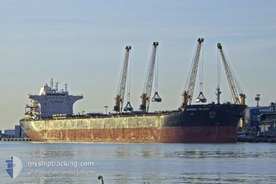
SARONIC TRADER
Bulk Carrier
Current Trip
| Time Travelled | 23 h, 27 mins |
|---|---|
| Remaining Time | 16 h, 50 mins |
| Distance Travelled | 205.98 nm |
| Remaining Distance | 142.70 nm |
| AVG Speed | 8.8 Knopen |
| MAX Speed | 10.5 Knopen |
| AVG Wind | 20 knots |
| MAX Wind | 26.2 knots |
| MIN Temp | 22.7°C / 72.86°F |
| MAX Temp | 23.9°C / 75.02°F |
| Diepgang | 9.6 M |
| Positie ontvangen | 21 h, 19 m geleden |
Current Position
| Lengtegraad | 31.40049° |
|---|---|
| Breedtegraat | -29.72400° |
| Status | Under way using engine |
| Snelheid | 10.6 Knopen |
| Koers | 45.7° |
| Gebied | Indian Ocean |
| Station | T-AIS |
| Positie ontvangen | 21 h, 19 m geleden |
Info
Information
The current position of SARONIC TRADER is in Indian Ocean with coordinates -29.72400° / 31.40049° as reported on 2025-12-13 07:56 by AIS to our vessel tracker app. The vessel's current speed is 10.6 Knopen and is heading at the port of MAPUTO. The estimated time of arrival as calculated by MyShipTracking vessel tracking app is 2025-12-15 00:06 LT
The vessel SARONIC TRADER (IMO: 9453535, MMSI: 636014899) is a Bulk Carrier that was built in 2011 ( 14 Jaar oud ). It's sailing under the flag of [LR] Liberia.
In this page you can find informations about the vessels current position, last detected port calls, and current voyage information. If the vessels is not in coverage by AIS you will find the latest position.
The current position of SARONIC TRADER is detected by our AIS receivers and we are not responsible for the reliability of the data. The last position was recorded while the vessel was in Coverage by the Ais receivers of our vessel tracking app.
The current draught of SARONIC TRADER as reported by AIS is 9.6 meters
Weather
| Temperature | 24°C / 75.2°F |
|---|---|
| Wind Speed | 23 knots |
| Direction | 162° SSE |
| Pressure | 1018.6 hPa |
| Humidity | 84 % |
| Cloud Coverage | 100 % |
Featured Company
Events
| Tijd | Evenement | Details | Positie / Bestemming | Info |
|---|---|---|---|---|
| 2025-12-13 08:01 | Status Changed | Default Under way using engine |
-29.71291 / 31.41339
MZMPM
|
Snelheid: 10.6 kn Koers: 45.7° |
| 2025-12-13 07:56 | Buitenbereik |
-29.72400 / 31.40049
Indian Ocean
MZMPM
|
Snelheid: 10.6 kn Koers: 45.7° |
|
| 2025-12-13 06:07 | ETA Changed | 2025/12/14 18:00 2025/12/10 12:00 |
-29.84158 / 31.09815
MZMPM
|
Snelheid: 8.9 kn Koers: 53.2° |
| 2025-12-13 05:49 | Vertrekhaven |
|
-29.86660 / 31.05969
MZMPM
|
Snelheid: 5.5 kn Koers: 34° |
| 2025-12-13 05:40 | Start beweging |
-29.87719 / 31.05140
[ZA] DURBAN
|
Snelheid: 3.1 kn Koers: 29° |
|
| 2025-12-13 05:31 | Status Changed | Under way using engine Moored |
-29.87969 / 31.05036
[ZA] DURBAN
|
Snelheid: Koers: 38° |
| 2025-12-13 05:27 | Status Changed | Moored Default |
-29.87974 / 31.05040
[ZA] DURBAN
|
Snelheid: Koers: 38° |
| 2025-12-13 05:23 | Status Changed | Default Moored |
-29.87974 / 31.05039
[ZA] DURBAN
|
Snelheid: Koers: 38° |
| 2025-12-13 05:15 | Status Changed | Moored Default |
-29.87977 / 31.05039
[ZA] DURBAN
|
Snelheid: Koers: 38° |
| 2025-12-13 05:11 | Status Changed | Default Moored |
-29.87974 / 31.05038
[ZA] DURBAN
|
Snelheid: Koers: 38° |