

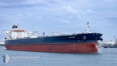
SEAVISION
Tanker

Current Trip
| Time Travelled | 17 days |
|---|---|
| Remaining Time | --- |
| Distance Travelled | 2988.08 nm |
| Remaining Distance | --- |
| AVG Speed | 11.1 Knopen |
| MAX Speed | 14.9 Knopen |
| AVG Wind | 12 knots |
| MAX Wind | 25.8 knots |
| MIN Temp | 11.3°C / 52.34°F |
| MAX Temp | 27.1°C / 80.78°F |
| Diepgang | 9.3 M |
| Positie ontvangen | 2 m geleden |
Current Position
| Lengtegraad | 23.53234° |
|---|---|
| Breedtegraat | 37.86254° |
| Status | At anchor |
| Snelheid | |
| Koers | 288° |
| Gebied | Aegean Sea |
| Station | T-AIS |
| Positie ontvangen | 2 m geleden |
Information
The current position of SEAVISION is in Aegean Sea with coordinates 37.86254° / 23.53234° as reported on 2025-06-06 05:02 by AIS to our vessel tracker app. The vessel's current speed is 0 Knopen
The vessel SEAVISION (IMO: 9790971, MMSI: 248547000) is a Tanker It's sailing under the flag of [MT] Malta.
In this page you can find informations about the vessels current position, last detected port calls, and current voyage information. If the vessels is not in coverage by AIS you will find the latest position.
The current position of SEAVISION is detected by our AIS receivers and we are not responsible for the reliability of the data. The last position was recorded while the vessel was in Coverage by the Ais receivers of our vessel tracking app.
The current draught of SEAVISION as reported by AIS is 9.3 meters
Weather
| Temperature | 22.7°C / 72.86°F |
|---|---|
| Wind Speed | 12 knots |
| Direction | 314° NW |
| Pressure | 1015.5 hPa |
| Humidity | 73.8 % |
| Cloud Coverage | --- |


Featured Company
Most Visited Ports (Last year)
| Port | Arrivals | |
|---|---|---|
| 2 | ||
| 2 | ||
| 2 | ||
| 2 | ||
| 1 | ||
| 1 |
Events
| Tijd | Evenement | Details | Positie / Bestemming | Info |
|---|---|---|---|---|
| 2025-06-06 01:09 | ETA Changed | 2026/05/30 02:00 2026/01/01 02:00 |
37.86084 / 23.52889
GRPIR
|
Snelheid: 0.1 kn Koers: 17° |
| 2025-06-06 00:57 | ETA Changed | 2026/01/01 02:00 2026/05/30 02:00 |
37.86071 / 23.52853
GRPIR
|
Snelheid: Koers: 26° |
| 2025-06-05 14:18 | ETA Changed | 2026/05/30 02:00 2026/01/01 02:00 |
37.86162 / 23.53160
GRPIR
|
Snelheid: Koers: 322° |
| 2025-06-05 14:12 | ETA Changed | 2026/01/01 02:00 2026/05/30 02:00 |
37.86165 / 23.53163
GRPIR
|
Snelheid: Koers: 320° |
| 2025-06-05 10:42 | ETA Changed | 2026/05/30 02:00 2026/01/01 02:00 |
37.86353 / 23.53276
GRPIR
|
Snelheid: Koers: 263° |
| 2025-06-05 10:36 | ETA Changed | 2026/01/01 02:00 2026/05/30 02:00 |
37.86344 / 23.53279
GRPIR
|
Snelheid: Koers: 267° |
| 2025-06-05 02:42 | ETA Changed | 2026/05/30 02:00 2026/01/01 02:00 |
37.86220 / 23.52715
GRPIR
|
Snelheid: Koers: 77° |
| 2025-06-05 02:36 | ETA Changed | 2026/01/01 02:00 2026/05/30 02:00 |
37.86201 / 23.52725
GRPIR
|
Snelheid: 0.1 kn Koers: 72° |
| 2025-06-04 23:18 | ETA Changed | 2026/05/30 02:00 2026/01/01 02:00 |
37.86185 / 23.52755
GRPIR
|
Snelheid: Koers: 60° |
| 2025-06-04 23:12 | ETA Changed | 2026/01/01 02:00 2026/05/30 02:00 |
37.86194 / 23.52757
GRPIR
|
Snelheid: Koers: 64° |