
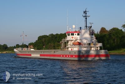
SPEYK
General Cargo
Current Trip
| Time Travelled | 2 days |
|---|---|
| Remaining Time | 1 day |
| Distance Travelled | 689.56 nm |
| Remaining Distance | 414.01 nm |
| AVG Speed | 11 Knopen |
| MAX Speed | 11.8 Knopen |
| AVG Wind | 14.1 knots |
| MAX Wind | 23 knots |
| MIN Temp | 0.2°C / 32.36°F |
| MAX Temp | 3.7°C / 38.66°F |
| Diepgang | 5.1 M |
| Positie ontvangen | 1 m geleden |
Current Position
| Lengtegraad | 10.48707° |
|---|---|
| Breedtegraat | 54.55066° |
| Status | Under way using engine |
| Snelheid | 9.6 Knopen |
| Koers | 245.7° |
| Gebied | Baltic Sea |
| Station | T-AIS |
| Positie ontvangen | 1 m geleden |
Info
Information
The current position of SPEYK is in Baltic Sea with coordinates 54.55066° / 10.48707° as reported on 2025-02-09 03:08 by AIS to our vessel tracker app. The vessel's current speed is 9.6 Knopen and is heading at the port of HULL. The estimated time of arrival as calculated by MyShipTracking vessel tracking app is 2025-02-10 22:16 LT
The vessel SPEYK (IMO: 9374698, MMSI: 244110938) is a General Cargo that was built in 2007 ( 18 Jaar oud ). It's sailing under the flag of [NL] Netherlands.
In this page you can find informations about the vessels current position, last detected port calls, and current voyage information. If the vessels is not in coverage by AIS you will find the latest position.
The current position of SPEYK is detected by our AIS receivers and we are not responsible for the reliability of the data. The last position was recorded while the vessel was in Coverage by the Ais receivers of our vessel tracking app.
The current draught of SPEYK as reported by AIS is 5.1 meters
Weather
| Temperature | 2.8°C / 37.04°F |
|---|---|
| Wind Speed | 11 knots |
| Direction | 91° E |
| Pressure | 1031 hPa |
| Humidity | 83.6 % |
| Cloud Coverage | 100 % |
Featured Company
Last Port Calls
| Port | Arrival | Departure | Time In Port |
|---|---|---|---|
| 2025-02-05 03:01 | 2025-02-06 14:33 | 1 d | |
| 2025-02-03 06:49 | 2025-02-03 20:05 | 13 h | |
| 2025-01-28 05:08 | 2025-01-29 14:50 | 1 d | |
| 2025-01-26 17:16 | 2025-01-27 20:17 | 1 d | |
| 2025-01-23 00:26 | 2025-01-26 17:15 | 3 d | |
| 2025-01-18 16:17 | 2025-01-20 22:21 | 2 d | |
| 2025-01-04 18:21 | 2025-01-05 17:15 | 22 h | |
| 2024-12-30 14:19 | 2025-01-04 16:57 | 5 d | |
| 2024-12-13 06:20 | 2024-12-15 12:23 | 2 d | |
| 2024-12-07 23:33 | 2024-12-08 02:27 | 2 h |
Most Visited Ports (Last year)
| Port | Arrivals | |
|---|---|---|
| 4 | ||
| 3 | ||
| 3 | ||
| 2 | ||
| 2 | ||
| 2 |
Last Trips
| Origin | Departure | Destination | Arrival | Distance | |
|---|---|---|---|---|---|
| 2025-02-03 20:05 | 2025-02-05 03:01 | 353.41 nm | |||
| 2025-01-29 14:50 | 2025-02-03 06:49 | 976.04 nm | |||
| 2025-01-27 20:17 | 2025-01-28 05:08 | 87.57 nm | |||
| 2025-01-26 17:15 | 2025-01-26 17:16 | 0.16 nm | |||
| 2025-01-20 22:21 | 2025-01-23 00:26 | 424.46 nm | |||
| 2025-01-05 17:15 | 2025-01-18 16:17 | 1764.88 nm | |||
| 2025-01-04 16:57 | 2025-01-04 18:21 | 6.14 nm | |||
| 2024-12-15 12:23 | 2024-12-30 14:19 | 1241.83 nm | |||
| 2024-12-08 02:27 | 2024-12-13 06:20 | 1142.41 nm | |||
| 2024-12-07 15:39 | 2024-12-07 23:33 | 50.14 nm |
Events
| Tijd | Evenement | Details | Positie / Bestemming | Info |
|---|---|---|---|---|
| 2025-02-09 02:52 | Wijzig zee gebeid | German part of the Baltic Sea Danish part of the Baltic Sea |
54.56616 / 10.55610
Baltic Sea
HULL
|
Snelheid: 9.5 kn Koers: 248.9° |
| 2025-02-09 01:58 | Wijzig zee gebeid | Danish part of the Baltic Sea German part of the Baltic Sea |
54.58757 / 10.80244
Baltic Sea
HULL
|
Snelheid: 9.2 kn Koers: 263.9° |
| 2025-02-09 00:04 | Wijzig zee gebeid | German part of the Baltic Sea Danish part of the Baltic Sea |
54.55962 / 11.33845
Baltic Sea
HULL
|
Snelheid: 10.6 kn Koers: 294.4° |
| 2025-02-08 19:59 | Gevonden in zee | Danish part of the Baltic Sea |
54.67897 / 12.42776
Baltic Sea
HULL
|
Snelheid: 11.6 kn Koers: 236.4° |
| 2025-02-08 19:53 | Wijzig zee gebeid | German part of the Baltic Sea Danish part of the Baltic Sea |
54.68955 / 12.45571
Baltic Sea
HULL
|
Snelheid: 11.5 kn Koers: 236.4° |
| 2025-02-08 18:25 | Gevonden in zee | Danish part of the Baltic Sea |
54.81658 / 12.88551
Baltic Sea
HULL
|
Snelheid: 11.3 kn Koers: 252.2° |
| 2025-02-08 15:20 | Gevonden in zee | German part of the Baltic Sea |
55.00111 / 13.83625
Baltic Sea
HULL
|
Snelheid: 11.2 kn Koers: 250° |
| 2025-02-08 11:47 | Gevonden in zee | Swedish part of the Baltic Sea |
55.44528 / 14.66210
Baltic Sea
HULL
|
Snelheid: 10.6 kn Koers: 235.8° |
| 2025-02-08 09:41 | Wijzig zee gebeid | Danish part of the Kattegat Swedish part of the Baltic Sea |
55.64334 / 15.24332
Kattegat
HULL
|
Snelheid: 11.2 kn Koers: 239.9° |
| 2025-02-08 04:29 | Status Changed | Under way using engine Default |
56.13160 / 16.71745
HULL
|
Snelheid: 10.9 kn Koers: 227° |