
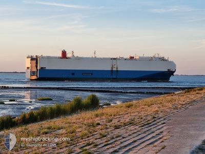
SPLENDID ACE
Vehicles Carrier
Current Trip
| Time Travelled | 5 h, 20 mins |
|---|---|
| Remaining Time | 10 h, 22 mins |
| Distance Travelled | 76.64 nm |
| Remaining Distance | 217.82 nm |
| AVG Speed | 14.7 Knopen |
| MAX Speed | 17 Knopen |
| AVG Wind | 12.8 knots |
| MAX Wind | 20.8 knots |
| MIN Temp | 26.1°C / 78.98°F |
| MAX Temp | 28.8°C / 83.84°F |
| Diepgang | 8.7 M |
| Positie ontvangen | 3 h, 47 m geleden |
Current Position
| Lengtegraad | -69.66371° |
|---|---|
| Breedtegraat | 18.17581° |
| Status | Under way using engine |
| Snelheid | 14 Knopen |
| Koers | 104.4° |
| Gebied | Caribbean Sea |
| Station | T-AIS |
| Positie ontvangen | 3 h, 47 m geleden |
Info
Information
The current position of SPLENDID ACE is in Caribbean Sea with coordinates 18.17581° / -69.66371° as reported on 2025-02-07 21:23 by AIS to our vessel tracker app. The vessel's current speed is 14 Knopen and is heading at the port of SAN JUAN. The estimated time of arrival as calculated by MyShipTracking vessel tracking app is 2025-02-08 07:33 LT
The vessel SPLENDID ACE (IMO: 9252228, MMSI: 431349000) is a Vehicles Carrier that was built in 2003 ( 22 Jaar oud ). It's sailing under the flag of [JP] Japan.
In this page you can find informations about the vessels current position, last detected port calls, and current voyage information. If the vessels is not in coverage by AIS you will find the latest position.
The current position of SPLENDID ACE is detected by our AIS receivers and we are not responsible for the reliability of the data. The last position was recorded while the vessel was in Coverage by the Ais receivers of our vessel tracking app.
The current draught of SPLENDID ACE as reported by AIS is 8.7 meters
Weather
| Temperature | 26.1°C / 78.98°F |
|---|---|
| Wind Speed | 21 knots |
| Direction | 57° ENE |
| Pressure | 1017.3 hPa |
| Humidity | 75.7 % |
| Cloud Coverage | --- |
Featured Company
Last Port Calls
| Port | Arrival | Departure | Time In Port |
|---|---|---|---|
| 2025-02-07 08:26 | 2025-02-07 15:51 | 7 h | |
| 2025-02-05 09:35 | 2025-02-05 23:19 | 13 h | |
| 2025-01-10 07:09 | 2025-01-11 17:44 | 1 d | |
| 2025-01-04 13:44 | 2025-01-06 13:54 | 2 d | |
| 2024-12-29 07:18 | 2024-12-29 16:37 | 9 h | |
| 2024-12-03 18:43 |
Most Visited Ports (Last year)
| Port | Arrivals | |
|---|---|---|
| 3 | ||
| 3 | ||
| 2 | ||
| 2 | ||
| 2 | ||
| 2 |
Last Trips
| Origin | Departure | Destination | Arrival | Distance | |
|---|---|---|---|---|---|
| 2025-02-05 23:19 | 2025-02-07 08:26 | 438.89 nm | |||
| 2025-01-11 17:44 | 2025-02-05 09:35 | 9480.75 nm | |||
| 2025-01-06 13:54 | 2025-01-10 07:09 | 768.11 nm | |||
| 2024-12-29 16:37 | 2025-01-04 13:44 | 519.35 nm | |||
| 2024-12-03 18:43 | 2024-12-29 07:18 | 10086.51 nm |
Events
| Tijd | Evenement | Details | Positie / Bestemming | Info |
|---|---|---|---|---|
| 2025-02-07 21:27 | Status Changed | Default Under way using engine |
18.17157 / -69.64790
PRSJU
|
Snelheid: 14 kn Koers: 104.4° |
| 2025-02-07 21:23 | Buitenbereik |
18.17581 / -69.66371
Caribbean Sea
PRSJU
|
Snelheid: 14 kn Koers: 104.4° |
|
| 2025-02-07 21:23 | Status Changed | Under way using engine Default |
18.17601 / -69.66450
PRSJU
|
Snelheid: 14.7 kn Koers: 125° |
| 2025-02-07 21:18 | Status Changed | Default Under way using engine |
18.18303 / -69.68293
PRSJU
|
Snelheid: 16.2 kn Koers: 141.4° |
| 2025-02-07 20:14 | ETA Changed | 2025/02/08 14:30 2025/02/08 16:00 |
18.40237 / -69.87120
PRSJU
|
Snelheid: 13.6 kn Koers: 143.7° |
| 2025-02-07 19:51 | Vertrekhaven |
|
18.46182 / -69.88896
PRSJU
|
Snelheid: 7.3 kn Koers: 225° |
| 2025-02-07 19:50 | ETA Changed | 2025/02/08 16:00 2025/02/07 19:42 |
18.46349 / -69.88721
[DO] SANTO DOMINGO
|
Snelheid: 6.9 kn Koers: 225° |
| 2025-02-07 19:46 | Start beweging |
18.46797 / -69.88208
[DO] SANTO DOMINGO
|
Snelheid: 3.4 kn Koers: 227° |
|
| 2025-02-07 19:43 | Destination Changed | PRSJU JM KIN - DO SDQ |
18.46939 / -69.88044
[DO] SANTO DOMINGO
|
Snelheid: 2 kn Koers: 228° |
| 2025-02-07 19:43 | ETA Changed | 2025/02/07 19:42 2025/02/07 09:00 |
18.46939 / -69.88044
[DO] SANTO DOMINGO
|
Snelheid: 2 kn Koers: 228° |