
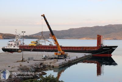
TAXIARCHIS MICHAIL
General Cargo
Current Trip
| Time Travelled | 11 h, 2 mins |
|---|---|
| Remaining Time | -13 mins |
| Distance Travelled | 48.92 nm |
| Remaining Distance | 0.90 nm |
| AVG Speed | 7.3 Knopen |
| MAX Speed | 9.6 Knopen |
| AVG Wind | 11.2 knots |
| MAX Wind | 16 knots |
| MIN Temp | 7.8°C / 46.04°F |
| MAX Temp | 11.7°C / 53.06°F |
| Diepgang | 3.2 M |
| Positie ontvangen | 1 m geleden |
Current Position
| Lengtegraad | 25.87770° |
|---|---|
| Breedtegraat | 35.17580° |
| Status | Under way using engine |
| Snelheid | 1.6 Knopen |
| Koers | 80° |
| Gebied | Aegean Sea |
| Station | T-AIS |
| Positie ontvangen | 1 m geleden |
Info
Information
The current position of TAXIARCHIS MICHAIL is in Aegean Sea with coordinates 35.17580° / 25.87770° as reported on 2025-02-13 05:09 by AIS to our vessel tracker app. The vessel's current speed is 1.6 Knopen and is heading at the port of ALTSI. The estimated time of arrival as calculated by MyShipTracking vessel tracking app is 2025-02-13 04:58 LT
The vessel TAXIARCHIS MICHAIL (IMO: 8505941, MMSI: 241848000) is a General Cargo that was built in 1985 ( 40 Jaar oud ). It's sailing under the flag of [GR] Greece.
In this page you can find informations about the vessels current position, last detected port calls, and current voyage information. If the vessels is not in coverage by AIS you will find the latest position.
The current position of TAXIARCHIS MICHAIL is detected by our AIS receivers and we are not responsible for the reliability of the data. The last position was recorded while the vessel was in Coverage by the Ais receivers of our vessel tracking app.
The current draught of TAXIARCHIS MICHAIL as reported by AIS is 3.2 meters
Weather
| Temperature | 9.6°C / 49.28°F |
|---|---|
| Wind Speed | 10 knots |
| Direction | 329° NNW |
| Pressure | 1027.1 hPa |
| Humidity | 59.8 % |
| Cloud Coverage | 32 % |
Featured Company
Last Port Calls
| Port | Arrival | Departure | Time In Port |
|---|---|---|---|
| 2025-02-04 07:30 | 2025-02-12 18:09 | 8 d | |
| 2025-01-31 10:20 | 2025-02-03 06:07 | 2 d | |
| 2025-01-28 20:12 | 2025-01-30 11:37 | 1 d | |
| 2025-01-27 07:55 | 2025-01-27 21:17 | 13 h | |
| 2025-01-23 05:56 | 2025-01-23 11:38 | 5 h | |
| 2025-01-20 16:47 | 2025-01-21 18:05 | 1 d | |
| 2025-01-18 17:33 | 2025-01-19 18:56 | 1 d | |
| 2025-01-16 04:47 | 2025-01-18 15:05 | 2 d | |
| 2025-01-13 05:12 | 2025-01-14 12:13 | 1 d | |
| 2025-01-09 03:16 | 2025-01-11 05:20 | 2 d |
Last Trips
| Origin | Departure | Destination | Arrival | Distance | |
|---|---|---|---|---|---|
| 2025-02-03 09:07 | 2025-02-04 09:30 | 250.72 nm | |||
| 2025-01-30 13:37 | 2025-01-31 13:20 | 195.28 nm | |||
| 2025-01-27 23:17 | 2025-01-28 22:12 | 129.66 nm | |||
| 2025-01-23 13:38 | 2025-01-27 09:55 | 138.76 nm | |||
| 2025-01-21 20:05 | 2025-01-23 07:56 | 18.53 nm | |||
| 2025-01-19 20:56 | 2025-01-20 18:47 | 149.67 nm | |||
| 2025-01-18 17:05 | 2025-01-18 19:33 | 20.82 nm | |||
| 2025-01-14 14:13 | 2025-01-16 06:47 | 299.47 nm | |||
| 2025-01-11 08:20 | 2025-01-13 07:12 | 227.30 nm | |||
| 2025-01-08 08:41 | 2025-01-09 06:16 | 204.93 nm |
Events
| Tijd | Evenement | Details | Positie / Bestemming | Info |
|---|---|---|---|---|
| 2025-02-13 03:52 | Binnenbereik |
35.24666 / 25.75036
Aegean Sea
ALTSI
|
Snelheid: 7.5 kn Koers: 130.2° |
|
| 2025-02-13 01:23 | Buitenbereik |
35.24896 / 25.74497
Aegean Sea
ALTSI
|
Snelheid: 0.1 kn Koers: 327.6° |
|
| 2025-02-13 01:23 | Binnenbereik |
35.24896 / 25.74497
Aegean Sea
ALTSI
|
Snelheid: 0.1 kn Koers: 327.6° |
|
| 2025-02-12 23:44 | Buitenbereik |
35.24936 / 25.74570
Aegean Sea
ALTSI
|
Snelheid: 0.1 kn Koers: 145.1° |
|
| 2025-02-12 23:44 | Status Changed | At anchor Under way using engine |
35.24936 / 25.74570
ALTSI
|
Snelheid: 0.7 kn Koers: 328° |
| 2025-02-12 23:44 | Stop beweging | 1.38 nm, South East of ELOUNDA |
35.24936 / 25.74570
ALTSI
|
Snelheid: 0.1 kn Koers: 292° |
| 2025-02-12 21:54 | Binnenbereik |
35.37196 / 25.79797
Aegean Sea
ALTSI
|
Snelheid: 9.5 kn Koers: 157.2° |
|
| 2025-02-12 18:35 | Status Changed | Default Under way using engine |
35.36203 / 25.23509
ALTSI
|
Snelheid: 9 kn Koers: 83.4° |
| 2025-02-12 18:32 | Buitenbereik |
35.36124 / 25.22647
Aegean Sea
ALTSI
|
Snelheid: 9 kn Koers: 83.4° |
|
| 2025-02-12 18:09 | Draught Changed | 3.2 3.8 |
35.35138 / 25.15876
ALTSI
|
Snelheid: 7.2 kn Koers: 76.3° |