
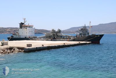
THANOS
Cement Carrier
Current Trip
| Time Travelled | 1 day |
|---|---|
| Remaining Time | --- |
| Distance Travelled | 30.85 nm |
| Remaining Distance | --- |
| AVG Speed | 8.6 Knopen |
| MAX Speed | 9.9 Knopen |
| AVG Wind | 11.7 knots |
| MAX Wind | 24.5 knots |
| MIN Temp | 5.6°C / 42.08°F |
| MAX Temp | 14.6°C / 58.28°F |
| Diepgang | 5 M |
| Positie ontvangen | 5 m geleden |
Current Position
| Lengtegraad | 26.92181° |
|---|---|
| Breedtegraat | 37.67574° |
| Status | At anchor |
| Snelheid | 0.3 Knopen |
| Koers | 27° |
| Gebied | Aegean Sea |
| Station | T-AIS |
| Positie ontvangen | 5 m geleden |
Info
Information
The current position of THANOS is in Aegean Sea with coordinates 37.67574° / 26.92181° as reported on 2025-02-05 12:48 by AIS to our vessel tracker app. The vessel's current speed is 0.3 Knopen
The vessel THANOS (IMO: 9054731, MMSI: 209874000) is a Cement Carrier that was built in 1992 ( 33 Jaar oud ). It's sailing under the flag of [CY] Cyprus.
In this page you can find informations about the vessels current position, last detected port calls, and current voyage information. If the vessels is not in coverage by AIS you will find the latest position.
The current position of THANOS is detected by our AIS receivers and we are not responsible for the reliability of the data. The last position was recorded while the vessel was in Coverage by the Ais receivers of our vessel tracking app.
The current draught of THANOS as reported by AIS is 5 meters
Weather
| Temperature | 9.1°C / 48.38°F |
|---|---|
| Wind Speed | 24 knots |
| Direction | 6° N |
| Pressure | 1020.8 hPa |
| Humidity | 49.9 % |
| Cloud Coverage | 6 % |
Featured Company
Last Port Calls
| Port | Arrival | Departure | Time In Port |
|---|---|---|---|
| 2025-02-03 05:21 | 2025-02-04 06:01 | 1 d | |
| 2025-02-01 06:01 | 2025-02-02 08:34 | 1 d | |
| 2025-01-29 05:23 | 2025-01-31 15:45 | 2 d | |
| 2025-01-27 06:13 | 2025-01-27 16:03 | 9 h | |
| 2025-01-25 07:16 | 2025-01-26 05:38 | 22 h | |
| 2025-01-22 07:35 | 2025-01-24 16:36 | 2 d | |
| 2025-01-20 09:18 | 2025-01-21 06:14 | 20 h | |
| 2025-01-15 07:39 | 2025-01-19 09:01 | 4 d | |
| 2025-01-14 05:13 | 2025-01-14 19:58 | 14 h | |
| 2025-01-08 08:48 | 2025-01-11 08:11 | 2 d |
Last Trips
| Origin | Departure | Destination | Arrival | Distance | |
|---|---|---|---|---|---|
| 2025-02-02 10:34 | 2025-02-03 07:21 | 117.57 nm | |||
| 2025-01-31 17:45 | 2025-02-01 08:01 | 82.07 nm | |||
| 2025-01-27 18:03 | 2025-01-29 07:23 | 247.89 nm | |||
| 2025-01-26 07:38 | 2025-01-27 08:13 | 166.01 nm | |||
| 2025-01-24 18:36 | 2025-01-25 09:16 | 138.02 nm | |||
| 2025-01-21 08:14 | 2025-01-22 09:35 | 247.77 nm | |||
| 2025-01-19 11:01 | 2025-01-20 11:18 | 98.06 nm | |||
| 2025-01-14 21:58 | 2025-01-15 09:39 | 107.05 nm | |||
| 2025-01-11 10:11 | 2025-01-14 07:13 | 80.02 nm | |||
| 2025-01-07 18:27 | 2025-01-08 10:48 | 149.84 nm |
Events
| Tijd | Evenement | Details | Positie / Bestemming | Info |
|---|---|---|---|---|
| 2025-02-04 22:43 | Status Changed | At anchor Default |
37.67728 / 26.92179
GRVTH
|
Snelheid: 0.1 kn Koers: 4° |
| 2025-02-04 22:36 | Status Changed | Default At anchor |
37.67730 / 26.92171
GRVTH
|
Snelheid: 0.1 kn Koers: 9° |
| 2025-02-04 09:42 | Status Changed | At anchor Under way using engine |
37.67763 / 26.92084
GRVTH
|
Snelheid: 0.2 kn Koers: 42° |
| 2025-02-04 09:30 | Stop beweging | 1.34 nm, South West of PYTHAGOREIO |
37.67761 / 26.92090
GRVTH
|
Snelheid: 0.2 kn Koers: 27° |
| 2025-02-04 09:14 | Start beweging | 1.1 nm, South West of PYTHAGOREIO |
37.68079 / 26.92442
GRVTH
|
Snelheid: 3.8 kn Koers: 225° |
| 2025-02-04 09:11 | Stop beweging | 0.95 nm, South West of PYTHAGOREIO |
37.68221 / 26.92706
GRVTH
|
Snelheid: 0.2 kn Koers: 301° |
| 2025-02-04 06:16 | Status Changed | Under way using engine Moored |
37.32901 / 26.60497
GRVTH
|
Snelheid: 9.8 kn Koers: 91.8° |
| 2025-02-04 06:16 | Destination Changed | GRVTH GRPMS |
37.32906 / 26.60274
GRVTH
|
Snelheid: 9.8 kn Koers: 91.8° |
| 2025-02-04 06:14 | ETA Changed | 2025/02/06 06:00 2025/02/02 20:00 |
37.32912 / 26.59930
GRPMS
|
Snelheid: 9.8 kn Koers: 91.7° |
| 2025-02-04 06:01 | Vertrekhaven |
|
37.32057 / 26.55716
GRPMS
|
Snelheid: 7.9 kn Koers: 131° |