
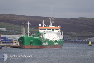
THUN BRITAIN
Tanker
Current Trip
| Time Travelled | 14 h, 47 mins |
|---|---|
| Remaining Time | 4 h, 59 mins |
| Distance Travelled | 169.23 nm |
| Remaining Distance | 30.99 nm |
| AVG Speed | 11.6 Knopen |
| MAX Speed | 15 Knopen |
| AVG Wind | 19.1 knots |
| MAX Wind | 25 knots |
| MIN Temp | 4.4°C / 39.92°F |
| MAX Temp | 8.5°C / 47.3°F |
| Diepgang | 4.4 M |
| Positie ontvangen | Nu |
Current Position
| Lengtegraad | 0.61909° |
|---|---|
| Breedtegraat | 53.49721° |
| Status | Under way using engine |
| Snelheid | 1.8 Knopen |
| Koers | 287° |
| Gebied | North Sea |
| Station | T-AIS |
| Positie ontvangen | Nu |
Info
Information
The current position of THUN BRITAIN is in North Sea with coordinates 53.49721° / 0.61909° as reported on 2025-02-04 22:35 by AIS to our vessel tracker app. The vessel's current speed is 1.8 Knopen and is heading at the port of IMMINGHAM. The estimated time of arrival as calculated by MyShipTracking vessel tracking app is 2025-02-05 03:35 LT
The vessel THUN BRITAIN (IMO: 9897482, MMSI: 244329000) is a Tanker It's sailing under the flag of [NL] Netherlands.
In this page you can find informations about the vessels current position, last detected port calls, and current voyage information. If the vessels is not in coverage by AIS you will find the latest position.
The current position of THUN BRITAIN is detected by our AIS receivers and we are not responsible for the reliability of the data. The last position was recorded while the vessel was in Coverage by the Ais receivers of our vessel tracking app.
The current draught of THUN BRITAIN as reported by AIS is 4.4 meters
Weather
| Temperature | 6.9°C / 44.42°F |
|---|---|
| Wind Speed | 20 knots |
| Direction | 253° WSW |
| Pressure | 1023.3 hPa |
| Humidity | 79.1 % |
| Cloud Coverage | 50 % |
Featured Company
Last Port Calls
| Port | Arrival | Departure | Time In Port |
|---|---|---|---|
| 2025-02-03 16:03 | 2025-02-04 07:49 | 15 h | |
| 2025-01-21 11:08 | 2025-02-03 15:30 | 13 d | |
| 2025-01-20 08:37 | 2025-01-20 15:41 | 7 h | |
| 2025-01-18 08:56 | 2025-01-18 18:33 | 9 h | |
| 2025-01-14 17:28 | 2025-01-15 14:38 | 21 h | |
| 2025-01-12 04:58 | 2025-01-12 17:25 | 12 h | |
| 2025-01-09 08:46 | 2025-01-10 10:06 | 1 d | |
| 2025-01-04 09:27 | 2025-01-04 19:25 | 9 h | |
| 2024-12-31 01:06 | 2025-01-01 14:22 | 1 d | |
| 2024-12-23 07:28 | 2024-12-23 15:45 | 8 h |
Last Trips
| Origin | Departure | Destination | Arrival | Distance | |
|---|---|---|---|---|---|
| 2025-02-03 16:30 | 2025-02-03 17:03 | 2.87 nm | |||
| 2025-01-20 15:41 | 2025-01-21 12:08 | 116.64 nm | |||
| 2025-01-18 18:33 | 2025-01-20 08:37 | 343.70 nm | |||
| 2025-01-15 14:38 | 2025-01-18 08:56 | 428.09 nm | |||
| 2025-01-12 17:25 | 2025-01-14 17:28 | 426.43 nm | |||
| 2025-01-10 10:06 | 2025-01-12 04:58 | 415.87 nm | |||
| 2025-01-04 19:25 | 2025-01-09 08:46 | 458.64 nm | |||
| 2025-01-01 14:22 | 2025-01-04 09:27 | 425.72 nm | |||
| 2024-12-23 15:45 | 2024-12-31 01:06 | 629.16 nm | |||
| 2024-12-20 08:15 | 2024-12-23 07:28 | 223.84 nm |
Events
| Tijd | Evenement | Details | Positie / Bestemming | Info |
|---|---|---|---|---|
| 2025-02-04 21:13 | Draught Changed | 4.4 4.6 |
53.41192 / .71948
GB IMM
|
Snelheid: 6.2 kn Koers: 295° |
| 2025-02-04 20:51 | Status Changed | Under way using engine Default |
53.39608 / .78494
GB IMM
|
Snelheid: 9.3 kn Koers: 287° |
| 2025-02-04 20:51 | Binnenbereik |
53.39608 / .78494
North Sea
|
Snelheid: 8.9 kn Koers: 293.6° |
|
| 2025-02-04 19:25 | Status Changed | Default Under way using engine |
53.26038 / 1.11662
GB IMM
|
Snelheid: 12.7 kn Koers: 320.7° |
| 2025-02-04 19:19 | Buitenbereik |
53.24401 / 1.13969
North Sea
|
Snelheid: 12.7 kn Koers: 320.7° |
|
| 2025-02-04 13:10 | Status Changed | Under way using engine Default |
52.39890 / 2.78921
GB IMM
|
Snelheid: 11.7 kn Koers: 293° |
| 2025-02-04 13:08 | Status Changed | Default Under way using engine |
52.39610 / 2.79878
GB IMM
|
Snelheid: 11.4 kn Koers: 301.2° |
| 2025-02-04 13:02 | Status Changed | Under way using engine Default |
52.38648 / 2.82979
GB IMM
|
Snelheid: 11.9 kn Koers: 301° |
| 2025-02-04 12:53 | Status Changed | Default Under way using engine |
52.37345 / 2.86879
GB IMM
|
Snelheid: 12.1 kn Koers: 300° |
| 2025-02-04 12:33 | Gevonden in zee | United Kingdom part of the North Sea |
52.33382 / 2.94925
North Sea
GB IMM
|
Snelheid: 11.4 kn Koers: 299.9° |