
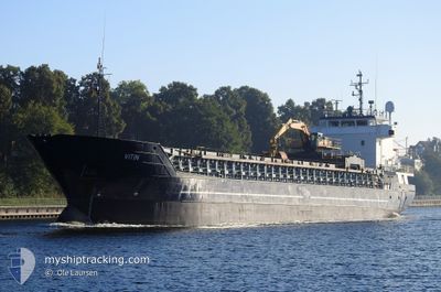
VITIN
General Cargo
Current Trip
| Time Travelled | 2 days |
|---|---|
| Remaining Time | --- |
| Distance Travelled | 462.69 nm |
| Remaining Distance | --- |
| AVG Speed | 7.6 Knopen |
| MAX Speed | 11.2 Knopen |
| AVG Wind | 20.5 knots |
| MAX Wind | 34.7 knots |
| MIN Temp | 2.4°C / 36.32°F |
| MAX Temp | 8.6°C / 47.48°F |
| Diepgang | 5.5 M |
| Positie ontvangen | Nu |
Current Position
| Lengtegraad | 1.64833° |
|---|---|
| Breedtegraat | 61.81932° |
| Status | Under way using engine |
| Snelheid | 7.8 Knopen |
| Koers | 274.5° |
| Gebied | Norwegian Sea |
| Station | T-AIS |
| Positie ontvangen | Nu |
Info
Information
The current position of VITIN is in Norwegian Sea with coordinates 61.81932° / 1.64833° as reported on 2025-02-07 16:28 by AIS to our vessel tracker app. The vessel's current speed is 7.8 Knopen and is heading at the port of SUND. The estimated time of arrival as calculated by MyShipTracking vessel tracking app is 2025-02-08 21:00 LT
The vessel VITIN (IMO: 9006289, MMSI: 231114000) is a General Cargo that was built in 1992 ( 33 Jaar oud ). It's sailing under the flag of [FO] Faroe Is.
In this page you can find informations about the vessels current position, last detected port calls, and current voyage information. If the vessels is not in coverage by AIS you will find the latest position.
The current position of VITIN is detected by our AIS receivers and we are not responsible for the reliability of the data. The last position was recorded while the vessel was in Coverage by the Ais receivers of our vessel tracking app.
The current draught of VITIN as reported by AIS is 5.5 meters
Weather
| Temperature | 7.7°C / 45.86°F |
|---|---|
| Wind Speed | 17 knots |
| Direction | 192° SSW |
| Pressure | 1038.6 hPa |
| Humidity | 74.3 % |
| Cloud Coverage | 7 % |
Featured Company
Last Port Calls
| Port | Arrival | Departure | Time In Port |
|---|---|---|---|
| 2025-02-04 21:33 | 2025-02-05 05:26 | 7 h | |
| 2025-02-04 06:28 | 2025-02-04 19:13 | 12 h | |
| 2025-02-01 16:53 | 2025-02-01 22:58 | 6 h | |
| 2025-01-31 05:09 | 2025-01-31 18:11 | 13 h | |
| 2025-01-24 16:54 | 2025-01-25 22:49 | 1 d | |
| 2025-01-22 06:05 | 2025-01-24 09:36 | 2 d | |
| 2025-01-21 17:24 | 2025-01-21 18:25 | 1 h | |
| 2025-01-15 22:25 | 2025-01-15 23:29 | 1 h | |
| 2025-01-15 08:32 | 2025-01-15 20:42 | 12 h | |
| 2025-01-15 06:14 | 2025-01-15 07:36 | 1 h |
Last Trips
| Origin | Departure | Destination | Arrival | Distance | |
|---|---|---|---|---|---|
| 2025-02-04 19:13 | 2025-02-04 21:33 | 17.92 nm | |||
| 2025-02-01 23:58 | 2025-02-04 06:28 | 448.17 nm | |||
| 2025-01-31 19:11 | 2025-02-01 17:53 | 268.89 nm | |||
| 2025-01-25 23:49 | 2025-01-31 06:09 | 1088.14 nm | |||
| 2025-01-24 10:36 | 2025-01-24 17:54 | 78.03 nm | |||
| 2025-01-21 19:25 | 2025-01-22 07:05 | 113.47 nm | |||
| 2025-01-16 00:29 | 2025-01-21 18:24 | 1162.33 nm | |||
| 2025-01-15 21:42 | 2025-01-15 23:25 | 6.06 nm | |||
| 2025-01-15 08:36 | 2025-01-15 09:32 | 2.51 nm | |||
| 2025-01-13 16:29 | 2025-01-15 07:14 | 347.28 nm |
Events
| Tijd | Evenement | Details | Positie / Bestemming | Info |
|---|---|---|---|---|
| 2025-02-07 11:31 | Status Changed | Under way using engine Default |
61.78825 / 2.90238
SUND
|
Snelheid: 7.9 kn Koers: 274° |
| 2025-02-07 11:29 | Status Changed | Default Under way using engine |
61.78814 / 2.90830
SUND
|
Snelheid: 7.3 kn Koers: 271.2° |
| 2025-02-07 03:23 | Start beweging | 4.42 nm, North West of FLORO |
61.66950 / 4.96799
SUND
|
Snelheid: 5.4 kn Koers: 325.9° |
| 2025-02-07 01:25 | Draught Changed | 5.5 3.6 |
61.66903 / 4.97290
SUND
|
Snelheid: Koers: 148° |
| 2025-02-07 01:25 | ETA Changed | 2025/02/08 21:00 2025/02/06 21:00 |
61.66903 / 4.97290
SUND
|
Snelheid: Koers: 148° |
| 2025-02-07 01:24 | Destination Changed | SUND SELJESTOKKEN |
61.66903 / 4.97290
SUND
|
Snelheid: Koers: 148° |
| 2025-02-06 20:31 | Stop beweging | 4.34 nm, North of FLORO |
61.66897 / 4.97284
SELJESTOKKEN
|
Snelheid: Koers: 145° |
| 2025-02-06 15:39 | ETA Changed | 2025/02/06 21:00 2025/02/06 19:00 |
61.82465 / 5.20410
SELJESTOKKEN
|
Snelheid: 3.7 kn Koers: 257° |
| 2025-02-06 07:26 | Draught Changed | 3.6 5.4 |
62.01657 / 2.67416
SELJESTOKKEN
|
Snelheid: 9.1 kn Koers: 97.9° |
| 2025-02-06 07:26 | Destination Changed | SELJESTOKKEN TORSHAVN |
62.01657 / 2.67416
SELJESTOKKEN
|
Snelheid: 9.1 kn Koers: 97.9° |