

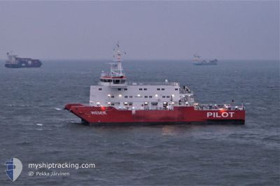
WESER PILOT
Pilot Ship

Current Trip
WESER RANGE PILOT
| Time Travelled | 10 days |
|---|---|
| Remaining Time | --- |
| Distance Travelled | 576.43 nm |
| Remaining Distance | --- |
| AVG Speed | 5.4 Knopen |
| MAX Speed | 15.6 Knopen |
| AVG Wind | 12.9 knots |
| MAX Wind | 30 knots |
| MIN Temp | 3.3°C / 37.94°F |
| MAX Temp | 13.1°C / 55.58°F |
| Diepgang | 6.4 M |
| Positie ontvangen | 11 m geleden |
Current Position
| Lengtegraad | 7.83319° |
|---|---|
| Breedtegraat | 53.85675° |
| Status | Under way using engine |
| Snelheid | 2.6 Knopen |
| Koers | 22° |
| Gebied | North Sea |
| Station | T-AIS |
| Positie ontvangen | 11 m geleden |
Information
The current position of WESER PILOT is in North Sea with coordinates 53.85675° / 7.83319° as reported on 2025-04-06 23:26 by AIS to our vessel tracker app. The vessel's current speed is 2.6 Knopen
The vessel WESER PILOT (IMO: 9514808, MMSI: 211464260) is a Pilot Ship that was built in 2009 ( 16 Jaar oud ). It's sailing under the flag of [DE] Germany.
In this page you can find informations about the vessels current position, last detected port calls, and current voyage information. If the vessels is not in coverage by AIS you will find the latest position.
The current position of WESER PILOT is detected by our AIS receivers and we are not responsible for the reliability of the data. The last position was recorded while the vessel was in Coverage by the Ais receivers of our vessel tracking app.
The current draught of WESER PILOT as reported by AIS is 6.4 meters
Weather
| Temperature | 6.1°C / 42.98°F |
|---|---|
| Wind Speed | 7 knots |
| Direction | 61° ENE |
| Pressure | 1027.2 hPa |
| Humidity | 75.6 % |
| Cloud Coverage | 6 % |


Featured Company
Last Port Calls
| Port | Arrival | Departure | Time In Port |
|---|---|---|---|
| 2025-03-27 11:24 | 2025-03-27 14:10 | 2 h | |
| 2025-03-13 11:14 | 2025-03-13 14:24 | 3 h | |
| 2025-02-27 11:13 | 2025-02-27 14:15 | 3 h | |
| 2025-02-12 09:50 | 2025-02-12 13:41 | 3 h |
Most Visited Ports (Last year)
| Port | Arrivals | |
|---|---|---|
| 23 | ||
| 1 |
Last Trips
| Origin | Departure | Destination | Arrival | Distance | |
|---|---|---|---|---|---|
| 2025-03-13 15:24 | 2025-03-27 12:24 | 821.13 nm | |||
| 2025-02-27 15:15 | 2025-03-13 12:14 | 872.16 nm | |||
| 2025-02-12 14:41 | 2025-02-27 12:13 | 815.38 nm | |||
| 2025-01-31 15:48 | 2025-02-12 10:50 | 682.44 nm |
Events
| Tijd | Evenement | Details | Positie / Bestemming | Info |
|---|---|---|---|---|
| 2025-04-06 23:25 | Start beweging | 5.07 nm, North of WANGEROOGE |
53.85569 / 7.83251
WESER RANGE PILOT
|
Snelheid: 3.8 kn Koers: 40° |
| 2025-04-06 22:42 | Stop beweging | 5.28 nm, North of WANGEROOGE |
53.86019 / 7.83984
WESER RANGE PILOT
|
Snelheid: 0.3 kn Koers: 109° |
| 2025-04-06 20:20 | Binnenbereik |
53.86350 / 7.87786
North Sea
|
Snelheid: 4.7 kn Koers: 7.1° |
|
| 2025-04-06 18:05 | Buitenbereik |
53.86767 / 7.80030
North Sea
|
Snelheid: 3.6 kn Koers: 146.3° |
|
| 2025-04-06 16:29 | Binnenbereik |
53.85853 / 7.87450
North Sea
|
Snelheid: 2.3 kn Koers: 53.8° |
|
| 2025-04-06 13:50 | Buitenbereik |
53.86066 / 7.83274
North Sea
|
Snelheid: 5.8 kn Koers: 311.4° |
|
| 2025-04-06 12:37 | Binnenbereik |
53.86926 / 7.84690
North Sea
|
Snelheid: 6.8 kn Koers: 132° |
|
| 2025-04-06 10:36 | Buitenbereik |
53.86331 / 7.83623
North Sea
|
Snelheid: 0.6 kn Koers: 233.5° |
|
| 2025-04-06 10:35 | Stop beweging | 5.49 nm, North of WANGEROOGE |
53.86335 / 7.83642
WESER RANGE PILOT
|
Snelheid: 0.3 kn Koers: 308° |
| 2025-04-06 10:15 | Binnenbereik |
53.86434 / 7.84500
North Sea
|
Snelheid: 3.1 kn Koers: 183.5° |