
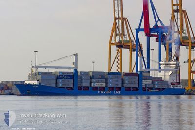
LEYLA KALKAVAN
Container Ship
Current Trip
| Time Travelled | 3 days |
|---|---|
| Remaining Time | 4 h, 49 mins |
| Distance Travelled | 999.15 морская миля |
| Remaining Distance | 85.67 морская миля |
| AVG Speed | 12.9 Узлы |
| MAX Speed | 18.5 Узлы |
| AVG Wind | 10.5 knots |
| MAX Wind | 29 knots |
| MIN Temp | 9.2°C / 48.56°F |
| MAX Temp | 22.3°C / 72.14°F |
| Осадка | 7.7 м |
| Позиция Получена | 1 d тому назад |
Current Position
| Долгота | 32.55115° |
|---|---|
| Широта | 29.87208° |
| Статус | Under way using engine |
| Скорость | 11.1 Узлы |
| Курс | 172.3° |
| Район | Gulf of Suez |
| Станция | T-AIS |
| Позиция Получена | 1 d тому назад |
Info
Information
The current position of LEYLA KALKAVAN is in Gulf of Suez with coordinates 29.87208° / 32.55115° as reported on 2025-02-11 16:36 by AIS to our vessel tracker app. The vessel's current speed is 11.1 Узлы and is heading at the port of JEDDAH. The estimated time of arrival as calculated by MyShipTracking vessel tracking app is 2025-02-13 06:06 LT
The vessel LEYLA KALKAVAN (IMO: 9126924, MMSI: 271044978) is a Container Ship that was built in 1997 ( 28 лет ). It's sailing under the flag of [TR] Turkey.
In this page you can find informations about the vessels current position, last detected port calls, and current voyage information. If the vessels is not in coverage by AIS you will find the latest position.
The current position of LEYLA KALKAVAN is detected by our AIS receivers and we are not responsible for the reliability of the data. The last position was recorded while the vessel was in Coverage by the Ais receivers of our vessel tracking app.
The current draught of LEYLA KALKAVAN as reported by AIS is 7.7 meters
Weather
| Temperature | 22.9°C / 73.22°F |
|---|---|
| Wind Speed | 16 knots |
| Direction | 335° NNW |
| Pressure | 1014.2 hPa |
| Humidity | 58.9 % |
| Cloud Coverage | 100 % |
Featured Company
Last Port Calls
| Port | Arrival | Departure | Time In Port |
|---|---|---|---|
| 2025-02-11 07:05 | 2025-02-11 16:00 | 8 h | |
| 2025-02-08 20:45 | 2025-02-09 10:21 | 13 h | |
| 2025-02-06 00:32 | 2025-02-08 15:02 | 2 d | |
| 2025-02-02 05:04 | 2025-02-02 14:29 | 9 h | |
| 2025-01-31 04:21 | 2025-01-31 15:46 | 11 h | |
| 2025-01-28 05:46 | 2025-01-29 01:02 | 19 h | |
| 2025-01-26 03:57 | 2025-01-26 12:39 | 8 h | |
| 2025-01-21 06:49 | 2025-01-24 12:10 | 3 d | |
| 2025-01-20 09:45 | 2025-01-20 20:25 | 10 h | |
| 2025-01-19 02:27 | 2025-01-20 02:38 | 1 d |
Most Visited Ports (Last year)
| Port | Arrivals | |
|---|---|---|
| 49 | ||
| 25 | ||
| 24 | ||
| 24 | ||
| 17 | ||
| 8 |
Last Trips
| Origin | Departure | Destination | Arrival | Distance | |
|---|---|---|---|---|---|
| 2025-02-09 13:21 | 2025-02-11 09:05 | 391.90 морская миля | |||
| 2025-02-08 18:02 | 2025-02-08 23:45 | 85.62 морская миля | |||
| 2025-01-31 17:46 | 2025-02-06 03:32 | 759.01 морская миля | |||
| 2025-01-31 17:46 | 2025-02-02 07:04 | 304.50 морская миля | |||
| 2025-01-29 04:02 | 2025-01-31 06:21 | 571.16 морская миля | |||
| 2025-01-24 15:10 | 2025-01-28 08:46 | 1108.27 морская миля | |||
| 2025-01-24 15:10 | 2025-01-26 05:57 | 389.86 морская миля | |||
| 2025-01-20 22:25 | 2025-01-21 09:49 | 142.96 морская миля | |||
| 2025-01-20 05:38 | 2025-01-20 11:45 | 114.27 морская миля | |||
| 2025-01-12 22:02 | 2025-01-19 05:27 | 1292.55 морская миля |
Events
| Время | Событие | Детали | Позиция / Направление | Информация |
|---|---|---|---|---|
| 2025-02-11 16:40 | Статус изменился | Default Under way using engine |
29.85874 / 32.55315
SAJED
|
Скорость: 11.1 kn Курс: 172.3° |
| 2025-02-11 16:36 | Вне покрытия |
29.87208 / 32.55115
Gulf of Suez
SAJED
|
Скорость: 11.1 kn Курс: 172.3° |
|
| 2025-02-11 16:35 | Пункт назначения изменился | SAJED EGSCN |
29.87426 / 32.55081
SAJED
|
Скорость: 11 kn Курс: 172.4° |
| 2025-02-11 16:35 | ETA изменился | 2025/02/13 07:00 2025/02/10 13:00 |
29.87426 / 32.55081
SAJED
|
Скорость: 11 kn Курс: 172.4° |
| 2025-02-11 16:01 | Изменение морского района | Egyptian part of the Gulf of Suez Egyptian part of the Mediterranean Sea - Eastern Basin |
29.94413 / 32.57610
Gulf of Suez
|
Скорость: 9.4 kn Курс: 217.4° |
| 2025-02-11 16:00 | ПОРТ ОТПРАВЛЕНИЯ |
|
29.94513 / 32.57693
EGSCN
|
Скорость: 9.4 kn Курс: 217° |
| 2025-02-11 14:16 | Статус изменился | Under way using engine Default |
30.24028 / 32.53569
[EG] SUEZ CANAL
|
Скорость: 10.6 kn Курс: 125° |
| 2025-02-11 13:59 | В покрытии |
30.24028 / 32.53569
Mediterranean Sea - Eastern Basin
[EG] SUEZ CANAL
|
Скорость: 10.6 kn Курс: 137.3° |
|
| 2025-02-11 07:05 | Порт |
|
31.22978 / 32.34628
[EG] SUEZ CANAL
|
Скорость: 7.6 kn Курс: 194° |
| 2025-02-11 05:32 | Начало движения | 7.11 nm, North of PORT SAID |
31.36799 / 32.33607
EGSCN
|
Скорость: 4.2 kn Курс: 70° |