
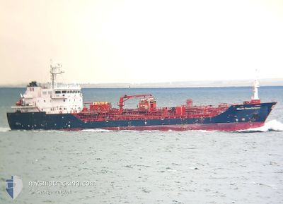
STOLT SANDPIPER
Oil/Chemical Tanker
Current Trip
| Time Travelled | 19 h, 25 mins |
|---|---|
| Remaining Time | --- |
| Distance Travelled | 151.49 морская миля |
| Remaining Distance | --- |
| AVG Speed | 13.9 Узлы |
| MAX Speed | 17.2 Узлы |
| AVG Wind | 12.2 knots |
| MAX Wind | 18.8 knots |
| MIN Temp | -0.6°C / 30.92°F |
| MAX Temp | 1.6°C / 34.88°F |
| Осадка | 5.7 м |
| Позиция Получена | 3 h, 23 m тому назад |
Current Position
| Долгота | 6.72590° |
|---|---|
| Широта | 55.21012° |
| Статус | Under way using engine |
| Скорость | 11.2 Узлы |
| Курс | 4.9° |
| Район | North Sea |
| Станция | T-AIS |
| Позиция Получена | 3 h, 23 m тому назад |
Info
Information
The current position of STOLT SANDPIPER is in North Sea with coordinates 55.21012° / 6.72590° as reported on 2025-02-14 09:21 by AIS to our vessel tracker app. The vessel's current speed is 11.2 Узлы and is heading at the port of RAFNES. The estimated time of arrival as calculated by MyShipTracking vessel tracking app is 2025-02-15 08:00 LT
The vessel STOLT SANDPIPER (IMO: 9566758, MMSI: 235089284) is a Oil/Chemical Tanker that was built in 2011 ( 14 лет ). It's sailing under the flag of [GB] United Kingdom.
In this page you can find informations about the vessels current position, last detected port calls, and current voyage information. If the vessels is not in coverage by AIS you will find the latest position.
The current position of STOLT SANDPIPER is detected by our AIS receivers and we are not responsible for the reliability of the data. The last position was recorded while the vessel was in Coverage by the Ais receivers of our vessel tracking app.
The current draught of STOLT SANDPIPER as reported by AIS is 5.7 meters
Weather
| Temperature | 1.2°C / 34.16°F |
|---|---|
| Wind Speed | 4 knots |
| Direction | 101° E |
| Pressure | 1029.1 hPa |
| Humidity | 63.6 % |
| Cloud Coverage | 99 % |
Featured Company
Last Port Calls
| Port | Arrival | Departure | Time In Port |
|---|---|---|---|
| 2025-02-12 12:53 | 2025-02-13 17:19 | 1 d | |
| 2025-02-10 01:09 | 2025-02-11 09:54 | 1 d | |
| 2025-02-07 18:24 | 2025-02-08 19:05 | 1 d | |
| 2025-02-03 03:44 | 2025-02-03 23:53 | 20 h | |
| 2025-01-30 11:39 | 2025-01-31 09:51 | 22 h | |
| 2025-01-28 04:02 | 2025-01-29 05:38 | 1 d | |
| 2025-01-26 21:45 | 2025-01-27 12:24 | 14 h | |
| 2025-01-24 23:45 | 2025-01-26 05:42 | 1 d | |
| 2025-01-23 08:11 | 2025-01-24 06:38 | 22 h | |
| 2025-01-21 12:39 | 2025-01-22 09:54 | 21 h |
Most Visited Ports (Last year)
| Port | Arrivals | |
|---|---|---|
| 14 | ||
| 14 | ||
| 10 | ||
| 9 | ||
| 6 | ||
| 5 |
Last Trips
| Origin | Departure | Destination | Arrival | Distance | |
|---|---|---|---|---|---|
| 2025-02-11 10:54 | 2025-02-12 13:53 | 293.93 морская миля | |||
| 2025-02-08 20:05 | 2025-02-10 02:09 | 196.90 морская миля | |||
| 2025-02-04 00:53 | 2025-02-07 19:24 | 386.38 морская миля | |||
| 2025-01-31 09:51 | 2025-02-03 04:44 | 421.79 морская миля | |||
| 2025-01-29 05:38 | 2025-01-30 11:39 | 115.06 морская миля | |||
| 2025-01-27 12:24 | 2025-01-28 04:02 | 92.05 морская миля | |||
| 2025-01-26 06:42 | 2025-01-26 21:45 | 197.55 морская миля | |||
| 2025-01-24 07:38 | 2025-01-25 00:45 | 49.40 морская миля | |||
| 2025-01-22 09:54 | 2025-01-23 09:11 | 265.74 морская миля | |||
| 2025-01-13 20:40 | 2025-01-21 12:39 | 596.34 морская миля |
Events
| Время | Событие | Детали | Позиция / Направление | Информация |
|---|---|---|---|---|
| 2025-02-14 09:39 | Статус изменился | Default Under way using engine |
55.26656 / 6.73419
NORAF
|
Скорость: 11.2 kn Курс: 4.9° |
| 2025-02-14 09:21 | Вне покрытия |
55.21012 / 6.72590
North Sea
NORAF
|
Скорость: 11.2 kn Курс: 4.9° |
|
| 2025-02-14 09:08 | В покрытии |
55.17697 / 6.72108
North Sea
NORAF
|
Скорость: 11.2 kn Курс: 4.8° |
|
| 2025-02-13 21:05 | Статус изменился | Default Under way using engine |
54.00025 / 8.27358
NORAF
|
Скорость: 11.6 kn Курс: 280.2° |
| 2025-02-13 20:58 | Статус изменился | Under way using engine Default |
53.99586 / 8.31489
NORAF
|
Скорость: 12.1 kn Курс: 283° |
| 2025-02-13 20:58 | Вне покрытия |
53.99586 / 8.31489
North Sea
NORAF
|
Скорость: 11.6 kn Курс: 280.2° |
|
| 2025-02-13 20:25 | Статус изменился | Default Under way using engine |
53.97429 / 8.49913
NORAF
|
Скорость: 13.2 kn Курс: 279.6° |
| 2025-02-13 20:20 | Статус изменился | Under way using engine Default |
53.97109 / 8.53370
NORAF
|
Скорость: 13.1 kn Курс: 279° |
| 2025-02-13 20:13 | Статус изменился | Default Under way using engine |
53.96721 / 8.57292
NORAF
|
Скорость: 13.8 kn Курс: 291.1° |
| 2025-02-13 17:19 | ПОРТ ОТПРАВЛЕНИЯ |
|
53.66843 / 9.51017
NORAF
|
Скорость: 13.6 kn Курс: 346° |