

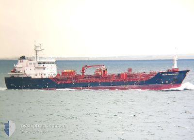
STOLT SANDPIPER
Oil/Chemical Tanker

Current Trip
| Time Travelled | 1 day |
|---|---|
| Remaining Time | --- |
| Distance Travelled | 249.28 nm |
| Remaining Distance | --- |
| AVG Speed | 12.6 Knots |
| MAX Speed | 14.6 Knots |
| AVG Wind | 14.4 knots |
| MAX Wind | 25 knots |
| MIN Temp | 10.2°C / 50.36°F |
| MAX Temp | 14.1°C / 57.38°F |
| Draught | 5.2 m |
| Position Received | 2 h, 12 m ago |
Current Position
| Longitude | 3.67199° |
|---|---|
| Latitude | 52.12240° |
| Status | At anchor |
| Speed | 0.3 Knots |
| Course | 232° |
| Area | North Sea |
| Station | T-AIS |
| Position Received | 2 h, 12 m ago |
Information
The current position of STOLT SANDPIPER is in North Sea with coordinates 52.12240° / 3.67199° as reported on 2025-06-09 01:41 by AIS to our vessel tracker app. The vessel's current speed is 0.3 Knots
The vessel STOLT SANDPIPER (IMO: 9566758, MMSI: 235089284) is a Oil/Chemical Tanker that was built in 2011 ( 14 years old ). It's sailing under the flag of [GB] United Kingdom.
In this page you can find informations about the vessels current position, last detected port calls, and current voyage information. If the vessels is not in coverage by AIS you will find the latest position.
The current position of STOLT SANDPIPER is detected by our AIS receivers and we are not responsible for the reliability of the data. The last position was recorded while the vessel was in Coverage by the Ais receivers of our vessel tracking app.
The current draught of STOLT SANDPIPER as reported by AIS is 5.2 meters
Weather
| Temperature | 13.9°C / 57.02°F |
|---|---|
| Wind Speed | 13 knots |
| Direction | 287° WNW |
| Pressure | 1020.2 hPa |
| Humidity | 80.1 % |
| Cloud Coverage | 37 % |


Featured Company
Last Port Calls
| Port | Arrival | Departure | Time In Port |
|---|---|---|---|
| 2025-06-06 15:23 | 2025-06-07 20:01 | 1 d | |
| 2025-06-01 02:06 | 2025-06-03 18:51 | 2 d | |
| 2025-05-29 09:10 | 2025-05-30 12:29 | 1 d | |
| 2025-05-26 07:16 | 2025-05-27 03:24 | 20 h | |
| 2025-05-24 19:39 | 2025-05-25 09:50 | 14 h | |
| 2025-05-24 10:17 | 2025-05-24 19:19 | 9 h | |
| 2025-05-24 00:47 | 2025-05-24 09:58 | 9 h | |
| 2025-05-22 10:22 | 2025-05-23 01:51 | 15 h | |
| 2025-05-21 04:29 | 2025-05-21 05:17 | 47 m | |
| 2025-05-16 23:28 | 2025-05-21 03:05 | 4 d |
Most Visited Ports (Last year)
| Port | Arrivals | |
|---|---|---|
| 14 | ||
| 11 | ||
| 10 | ||
| 7 | ||
| 6 | ||
| 6 |
Last Trips
| Origin | Departure | Destination | Arrival | Distance | |
|---|---|---|---|---|---|
| 2025-06-03 18:51 | 2025-06-06 15:23 | 303.28 nm | |||
| 2025-05-30 12:29 | 2025-06-01 02:06 | 113.88 nm | |||
| 2025-05-27 03:24 | 2025-05-29 09:10 | 410.11 nm | |||
| 2025-05-25 09:50 | 2025-05-26 07:16 | 113.64 nm | |||
| 2025-05-24 09:58 | 2025-05-24 19:39 | 6.04 nm | |||
| 2025-05-24 09:58 | 2025-05-24 10:17 | 2.12 nm | |||
| 2025-05-23 01:51 | 2025-05-24 00:47 | 256.98 nm | |||
| 2025-05-21 05:17 | 2025-05-22 10:22 | 204.60 nm | |||
| 2025-05-21 03:05 | 2025-05-21 04:29 | 5.99 nm | |||
| 2025-05-15 09:40 | 2025-05-16 23:28 | 411.45 nm |
Events
| Time | Event | Details | Position / Dest | Info |
|---|---|---|---|---|
| 2025-06-09 01:44 | Status Changed | Default At anchor |
52.12234 / 3.67195
NLRTM
|
Speed: 0.3 kn Course: 232° |
| 2025-06-09 01:41 | Status Changed | At anchor Default |
52.12240 / 3.67199
NLRTM
|
Speed: 0.2 kn Course: 228° |
| 2025-06-09 01:41 | OUT of Coverage |
52.12240 / 3.67199
North Sea
|
Speed: 0.3 kn Course: 93.7° |
|
| 2025-06-09 01:41 | Detected in Sea | Dutch part of the North Sea |
52.12240 / 3.67199
North Sea
|
Speed: 0.3 kn Course: 93.7° |
| 2025-06-09 01:26 | IN Coverage |
52.12240 / 3.67199
North Sea
|
Speed: 0.3 kn Course: 93.7° |
|
| 2025-06-08 14:35 | STOP Moving | 17.53 nm, North West of MAASVLAKTE - ROTTERDAM |
52.12114 / 3.67287
NLRTM
|
Speed: 0.3 kn Course: 269° |
| 2025-06-08 07:07 | Status Changed | Default Under way using engine |
52.99695 / 1.73286
NLRTM
|
Speed: 14.2 kn Course: 122.3° |
| 2025-06-08 07:02 | OUT of Coverage |
53.00575 / 1.70627
North Sea
NLRTM
|
Speed: 14.2 kn Course: 122.3° |
|
| 2025-06-08 06:37 | Status Changed | Under way using engine Default |
53.06518 / 1.57283
NLRTM
|
Speed: 14.1 kn Course: 132° |
| 2025-06-08 06:35 | Status Changed | Default Under way using engine |
53.07116 / 1.56135
NLRTM
|
Speed: 14.3 kn Course: 134.2° |