
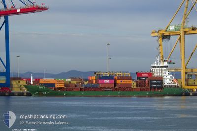
ANITA A
Container Ship
Current Trip
| Time Travelled | 2 days |
|---|---|
| Remaining Time | --- |
| Distance Travelled | 249.59 nm |
| Remaining Distance | --- |
| AVG Speed | 9.4 Knop |
| MAX Speed | 12 Knop |
| AVG Wind | 12.5 knots |
| MAX Wind | 18 knots |
| MIN Temp | 13.1°C / 55.58°F |
| MAX Temp | 18.7°C / 65.66°F |
| Djupgående | 6.7 m |
| Position mottagen | 6 h, 25 m sen |
Current Position
| Longitud | 32.55071° |
|---|---|
| Latitude | 29.87038° |
| Status | Under way using engine |
| Fart | 11.8 Knop |
| Kurs | 174° |
| Område | Gulf of Suez |
| Station | T-AIS |
| Position mottagen | 6 h, 25 m sen |
Info
Information
The current position of ANITA A is in Gulf of Suez with coordinates 29.87038° / 32.55071° as reported on 2025-02-13 16:12 by AIS to our vessel tracker app. The vessel's current speed is 11.8 Knop
The vessel ANITA A (IMO: 9532343, MMSI: 636021307) is a Container Ship that was built in 2009 ( 16 År gammal ). It's sailing under the flag of [LR] Liberia.
In this page you can find informations about the vessels current position, last detected port calls, and current voyage information. If the vessels is not in coverage by AIS you will find the latest position.
The current position of ANITA A is detected by our AIS receivers and we are not responsible for the reliability of the data. The last position was recorded while the vessel was in Coverage by the Ais receivers of our vessel tracking app.
The current draught of ANITA A as reported by AIS is 6.7 meters
Weather
| Temperature | 11.5°C / 52.7°F |
|---|---|
| Wind Speed | 9 knots |
| Direction | 359° N |
| Pressure | 1024.2 hPa |
| Humidity | 64.6 % |
| Cloud Coverage | 1 % |
Featured Company
Last Port Calls
| Port | Arrival | Departure | Time In Port |
|---|---|---|---|
| 2025-02-13 07:25 | 2025-02-13 15:43 | 8 h | |
| 2025-02-10 21:37 | 2025-02-11 14:55 | 17 h | |
| 2025-02-07 11:07 | 2025-02-08 01:41 | 14 h | |
| 2025-02-04 18:43 | 2025-02-05 00:51 | 6 h | |
| 2025-02-04 03:32 | 2025-02-04 11:50 | 8 h | |
| 2025-02-03 04:51 | 2025-02-03 14:13 | 9 h | |
| 2025-02-01 15:40 | 2025-02-02 06:00 | 14 h | |
| 2025-01-31 23:17 | 2025-02-01 12:31 | 13 h | |
| 2025-01-31 00:07 | 2025-01-31 09:05 | 8 h | |
| 2025-01-28 18:56 | 2025-01-29 08:30 | 13 h |
Most Visited Ports (Last year)
| Port | Arrivals | |
|---|---|---|
| 42 | ||
| 42 | ||
| 24 | ||
| 19 | ||
| 18 | ||
| 6 |
Last Trips
| Origin | Departure | Destination | Arrival | Distance | |
|---|---|---|---|---|---|
| 2025-02-11 16:55 | 2025-02-13 09:25 | 147.51 nm | |||
| 2025-02-08 04:41 | 2025-02-10 23:37 | 327.48 nm | |||
| 2025-02-05 02:51 | 2025-02-07 14:07 | 264.66 nm | |||
| 2025-02-04 13:50 | 2025-02-04 20:43 | 78.68 nm | |||
| 2025-02-02 08:00 | 2025-02-04 05:32 | 251.79 nm | |||
| 2025-02-02 08:00 | 2025-02-03 06:51 | 27.22 nm | |||
| 2025-01-31 11:05 | 2025-02-01 17:40 | 272.89 nm | |||
| 2025-01-31 11:05 | 2025-02-01 01:17 | 168.87 nm | |||
| 2025-01-29 10:30 | 2025-01-31 02:07 | 270.44 nm | |||
| 2025-01-27 21:21 | 2025-01-28 20:56 | 328.28 nm |
Events
| Tid | Event | Detaljer | Position / Dest | Information |
|---|---|---|---|---|
| 2025-02-13 18:02 | STOPPAR förflyttning | 3.88 nm, East of SOKHNA |
29.65955 / 32.43388
EGSOK
|
Fart: 0.2 kn Kurs: 29° |
| 2025-02-13 16:17 | Status ändrad | Default Under way using engine |
29.85415 / 32.55237
EGSOK
|
Fart: 11.8 kn Kurs: 174° |
| 2025-02-13 16:12 | UTANFÖR täckningsområde |
29.87038 / 32.55071
Gulf of Suez
EGSOK
|
Fart: 11.8 kn Kurs: 174° |
|
| 2025-02-13 15:43 | Byter havsområde | Egyptian part of the Gulf of Suez Israeli part of the Mediterranean Sea - Eastern Basin |
29.94461 / 32.57670
Gulf of Suez
EGSOK
|
Fart: 10.7 kn Kurs: 217.4° |
| 2025-02-13 15:43 | AVGÅTT HAMN |
|
29.94461 / 32.57670
EGSOK
|
Fart: 10.8 kn Kurs: 215° |
| 2025-02-13 15:34 | ETA ändrat | 2025/02/13 18:00 2025/02/13 16:00 |
29.96937 / 32.58645
[EG] SUEZ CANAL
|
Fart: 10.8 kn Kurs: 184° |
| 2025-02-13 14:40 | Destination ändrad | EGSOK EGPSD |
30.14186 / 32.57002
[EG] SUEZ CANAL
|
Fart: 11 kn Kurs: 181° |
| 2025-02-13 14:40 | ETA ändrat | 2025/02/13 16:00 2025/02/12 06:00 |
30.14186 / 32.57002
[EG] SUEZ CANAL
|
Fart: 11 kn Kurs: 181° |
| 2025-02-13 14:07 | Status ändrad | Under way using engine Default |
30.23798 / 32.53794
[EG] SUEZ CANAL
|
Fart: 11.1 kn Kurs: 133° |
| 2025-02-13 14:07 | I täckningsområde |
30.23798 / 32.53794
Mediterranean Sea - Eastern Basin
[EG] SUEZ CANAL
|
Fart: 11 kn Kurs: 146° |