

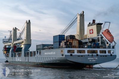
ANNETTE
Heavy Load Carrier
Current Trip
| Time Travelled | 5 days |
|---|---|
| Remaining Time | --- |
| Distance Travelled | 2541.71 nm |
| Remaining Distance | --- |
| AVG Speed | 16.8 Knop |
| MAX Speed | 19.9 Knop |
| AVG Wind | 16.5 knots |
| MAX Wind | 24.7 knots |
| MIN Temp | 8.9°C / 48.02°F |
| MAX Temp | 20.7°C / 69.26°F |
| Djupgående | 7.8 m |
| Position mottagen | 8 m sen |
Current Position
| Longitud | -23.27602° |
|---|---|
| Latitude | 17.14400° |
| Status | Under way using engine |
| Fart | 18 Knop |
| Kurs | 204.4° |
| Område | Celtic Sea |
| Station | T-AIS |
| Position mottagen | 8 m sen |
Information
The current position of ANNETTE is in Celtic Sea with coordinates 17.14400° / -23.27602° as reported on 2025-04-25 10:51 by AIS to our vessel tracker app. The vessel's current speed is 18 Knop and is heading at the port of ITAJAI. The estimated time of arrival as calculated by MyShipTracking vessel tracking app is 2025-05-02 15:00 LT
The vessel ANNETTE (IMO: 9266554, MMSI: 304577000) is a Heavy Load Carrier that was built in 2003 ( 22 År gammal ). It's sailing under the flag of [AG] Antigua Barbuda.
In this page you can find informations about the vessels current position, last detected port calls, and current voyage information. If the vessels is not in coverage by AIS you will find the latest position.
The current position of ANNETTE is detected by our AIS receivers and we are not responsible for the reliability of the data. The last position was recorded while the vessel was in Coverage by the Ais receivers of our vessel tracking app.
The current draught of ANNETTE as reported by AIS is 7.8 meters
Weather
| Temperature | 20.7°C / 69.26°F |
|---|---|
| Wind Speed | 19 knots |
| Direction | 30° NNE |
| Pressure | 1014.8 hPa |
| Humidity | 84 % |
| Cloud Coverage | 9 % |
Featured Company
Last Port Calls
| Port | Arrival | Departure | Time In Port |
|---|---|---|---|
| 2025-04-15 18:15 | 2025-04-19 13:54 | 3 d | |
| 2025-03-29 20:48 | 2025-04-01 07:26 | 2 d | |
| 2025-03-20 19:04 | 2025-03-26 15:54 | 5 d | |
| 2025-03-13 14:16 | 2025-03-15 17:45 | 2 d | |
| 2025-03-07 15:46 | 2025-03-09 08:51 | 1 d | |
| 2025-02-28 11:52 | 2025-03-06 02:38 | 5 d | |
| 2025-02-23 13:23 | 2025-02-24 06:52 | 17 h |
Last Trips
| Origin | Departure | Destination | Arrival | Distance | |
|---|---|---|---|---|---|
| 2025-04-01 07:26 | 2025-04-15 18:15 | 447.27 nm | |||
| 2025-03-26 15:54 | 2025-03-29 20:48 | 923.70 nm | |||
| 2025-03-15 17:45 | 2025-03-20 19:04 | 1688.09 nm | |||
| 2025-03-09 08:51 | 2025-03-13 14:16 | 1620.78 nm | |||
| 2025-03-06 02:38 | 2025-03-07 15:46 | 631.82 nm | |||
| 2025-02-24 06:52 | 2025-02-28 11:52 | 1611.19 nm | |||
| 2025-01-20 10:26 | 2025-02-23 13:23 | 13203.88 nm |
Events
| Tid | Event | Detaljer | Position / Dest | Information |
|---|---|---|---|---|
| 2025-04-25 10:47 | Byter havsområde | Cape Verdean part of the North Atlantic Ocean French part of the Celtic Sea |
17.16135 / -23.27042
North Atlantic Ocean
BR ITJ
|
Fart: 17.7 kn Kurs: 208.9° |
| 2025-04-25 10:47 | Status ändrad | Under way using engine Default |
17.16135 / -23.27042
BR ITJ
|
Fart: 18 kn Kurs: 193° |
| 2025-04-25 10:41 | I täckningsområde |
17.16135 / -23.27042
North Atlantic Ocean
BR ITJ
|
Fart: 17.7 kn Kurs: 208.9° |
|
| 2025-04-20 16:18 | Status ändrad | Default Under way using engine |
48.37673 / -6.56482
BR ITJ
|
Fart: 17 kn Kurs: 207° |
| 2025-04-20 16:10 | UTANFÖR täckningsområde |
48.41015 / -6.53591
Celtic Sea
BR ITJ
|
Fart: 17 kn Kurs: 207° |
|
| 2025-04-20 15:58 | Upptäckt i hav | French part of the Celtic Sea |
48.45838 / -6.49411
Celtic Sea
BR ITJ
|
Fart: 17.2 kn Kurs: 208° |
| 2025-04-20 15:57 | Status ändrad | Under way using engine Default |
48.46220 / -6.49070
BR ITJ
|
Fart: 17.3 kn Kurs: 210° |
| 2025-04-20 15:52 | Status ändrad | Default Under way using engine |
48.48238 / -6.47275
BR ITJ
|
Fart: 17.4 kn Kurs: 209° |
| 2025-04-20 15:51 | Status ändrad | Under way using engine Default |
48.48653 / -6.46901
BR ITJ
|
Fart: 17.4 kn Kurs: 209° |
| 2025-04-20 15:37 | I täckningsområde |
48.48653 / -6.46901
English Channel
BR ITJ
|
Fart: 17.4 kn Kurs: 209° |