

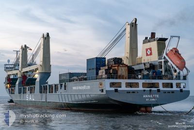
ANNETTE
Heavy Load Carrier

Current Trip
| Time Travelled | 2 days |
|---|---|
| Remaining Time | 16 h, 29 mins |
| Distance Travelled | 606.48 nm |
| Remaining Distance | 318.69 nm |
| AVG Speed | 15.8 Knots |
| MAX Speed | 21.1 Knots |
| AVG Wind | 11.5 knots |
| MAX Wind | 20 knots |
| MIN Temp | 8.1°C / 46.58°F |
| MAX Temp | 13.5°C / 56.3°F |
| Dybgang | 6.4 m |
| Position Modtaget | Nu |
Current Position
| Longitude | 2.85243° |
|---|---|
| Latitude | 51.94172° |
| Status | Under way using engine |
| Fart | 20 Knots |
| Kurs | 39.7° |
| Område | North Sea |
| Station | T-AIS |
| Position Modtaget | Nu |
Information
The current position of ANNETTE is in North Sea with coordinates 51.94172° / 2.85243° as reported on 2025-03-29 00:20 by AIS to our vessel tracker app. The vessel's current speed is 20 Knots and is heading at the port of HAMBURG. The estimated time of arrival as calculated by MyShipTracking vessel tracking app is 2025-03-29 16:50 LT
The vessel ANNETTE (IMO: 9266554, MMSI: 304577000) is a Heavy Load Carrier that was built in 2003 ( 22 år gamle ). It's sailing under the flag of [AG] Antigua Barbuda.
In this page you can find informations about the vessels current position, last detected port calls, and current voyage information. If the vessels is not in coverage by AIS you will find the latest position.
The current position of ANNETTE is detected by our AIS receivers and we are not responsible for the reliability of the data. The last position was recorded while the vessel was in Coverage by the Ais receivers of our vessel tracking app.
The current draught of ANNETTE as reported by AIS is 6.4 meters
Weather
| Temperature | 8.1°C / 46.58°F |
|---|---|
| Wind Speed | 15 knots |
| Direction | 315° NW |
| Pressure | 1015.1 hPa |
| Humidity | 75.6 % |
| Cloud Coverage | 100 % |


Featured Company
Last Port Calls
| Port | Arrival | Departure | Time In Port |
|---|---|---|---|
| 2025-03-20 18:04 | 2025-03-26 14:54 | 5 d | |
| 2025-03-13 13:16 | 2025-03-15 16:45 | 2 d | |
| 2025-03-07 14:46 | 2025-03-09 07:51 | 1 d | |
| 2025-02-28 10:52 | 2025-03-06 01:38 | 5 d | |
| 2025-02-23 13:23 | 2025-02-24 06:52 | 17 h | |
| 2025-01-18 01:49 | 2025-01-20 01:26 | 1 d | |
| 2025-01-15 13:57 | 2025-01-17 21:13 | 2 d | |
| 2025-01-14 00:15 | 2025-01-15 09:18 | 1 d | |
| 2025-01-11 23:25 | 2025-01-12 15:37 | 16 h | |
| 2025-01-05 06:12 | 2025-01-10 04:09 | 4 d |
Last Trips
| Origin | Departure | Destination | Arrival | Distance | |
|---|---|---|---|---|---|
| 2025-03-15 17:45 | 2025-03-20 19:04 | 1688.09 nm | |||
| 2025-03-09 08:51 | 2025-03-13 14:16 | 1620.78 nm | |||
| 2025-03-06 02:38 | 2025-03-07 15:46 | 631.82 nm | |||
| 2025-02-24 06:52 | 2025-02-28 11:52 | 1611.19 nm | |||
| 2025-01-20 10:26 | 2025-02-23 13:23 | 13203.88 nm | |||
| 2025-01-18 06:13 | 2025-01-18 10:49 | 67.69 nm | |||
| 2025-01-15 18:18 | 2025-01-15 22:57 | 66.51 nm | |||
| 2025-01-12 23:37 | 2025-01-14 09:15 | 522.42 nm | |||
| 2025-01-10 12:09 | 2025-01-12 07:25 | 565.64 nm | |||
| 2024-12-21 14:41 | 2025-01-05 14:12 | 2768.71 nm |
Events
| Tid | Hændelsen | Detaljer | Position / Dest | Info |
|---|---|---|---|---|
| 2025-03-28 23:46 | Ændre havområde | Dutch part of the North Sea Belgian part of the North Sea |
51.79900 / 2.66175
North Sea
DEHAM
|
Fart: 19.7 kn Kurs: 39.7° |
| 2025-03-28 22:37 | Ændre havområde | Belgian part of the North Sea French part of the North Sea |
51.51082 / 2.27759
North Sea
DEHAM
|
Fart: 19.2 kn Kurs: 36.7° |
| 2025-03-28 20:20 | Ændre havområde | French part of the North Sea French part of the English Channel |
51.00530 / 1.63556
North Sea
DEHAM
|
Fart: 16.4 kn Kurs: 55.6° |
| 2025-03-28 20:05 | ETA er ændret | 2025/03/29 15:00 2025/03/29 14:00 |
50.96977 / 1.54869
DEHAM
|
Fart: 16.1 kn Kurs: 40.9° |
| 2025-03-28 19:16 | Destination er ændret | DEHAM DECUX |
50.78685 / 1.39103
DEHAM
|
Fart: 16 kn Kurs: 18° |
| 2025-03-28 19:16 | ETA er ændret | 2025/03/29 14:00 2025/03/28 14:00 |
50.78685 / 1.39103
DEHAM
|
Fart: 16 kn Kurs: 18° |
| 2025-03-28 19:01 | Status er ændret | Under way using engine Default |
50.72095 / 1.35961
DECUX
|
Fart: 16.2 kn Kurs: 17° |
| 2025-03-28 18:58 | Status er ændret | Default Under way using engine |
50.70800 / 1.35341
DECUX
|
Fart: 16.3 kn Kurs: 45.8° |
| 2025-03-28 18:53 | Status er ændret | Under way using engine Default |
50.68740 / 1.33752
DECUX
|
Fart: 16.6 kn Kurs: 51° |
| 2025-03-28 18:42 | Status er ændret | Default Under way using engine |
50.65481 / 1.27720
DECUX
|
Fart: 17.2 kn Kurs: 48.6° |