
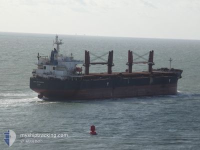
BULK INDEPENDENCE
Bulk Carrier
Current Trip
| Time Travelled | 13 days |
|---|---|
| Remaining Time | --- |
| Distance Travelled | 461.35 nm |
| Remaining Distance | --- |
| AVG Speed | 10.8 Knop |
| MAX Speed | 13.9 Knop |
| AVG Wind | 12.3 knots |
| MAX Wind | 23 knots |
| MIN Temp | 13.3°C / 55.94°F |
| MAX Temp | 25.6°C / 78.08°F |
| Djupgående | 6.2 m |
| Position mottagen | 3 d sen |
Current Position
| Longitud | 113.65528° |
|---|---|
| Latitude | 22.74322° |
| Status | Under way using engine |
| Fart | 11.6 Knop |
| Kurs | 323° |
| Område | South China Sea |
| Station | T-AIS |
| Position mottagen | 3 d sen |
Info
Information
The current position of BULK INDEPENDENCE is in South China Sea with coordinates 22.74322° / 113.65528° as reported on 2025-03-11 01:31 by AIS to our vessel tracker app. The vessel's current speed is 11.6 Knop
The vessel BULK INDEPENDENCE (IMO: 9374002, MMSI: 373904000) is a Bulk Carrier that was built in 2008 ( 17 År gammal ). It's sailing under the flag of [PA] Panama.
In this page you can find informations about the vessels current position, last detected port calls, and current voyage information. If the vessels is not in coverage by AIS you will find the latest position.
The current position of BULK INDEPENDENCE is detected by our AIS receivers and we are not responsible for the reliability of the data. The last position was recorded while the vessel was in Coverage by the Ais receivers of our vessel tracking app.
The current draught of BULK INDEPENDENCE as reported by AIS is 6.2 meters
Weather
| Temperature | 21.8°C / 71.24°F |
|---|---|
| Wind Speed | 4 knots |
| Direction | 166° SSE |
| Pressure | 1014.5 hPa |
| Humidity | 88.9 % |
| Cloud Coverage | 100 % |
Featured Company
Events
| Tid | Event | Detaljer | Position / Dest | Information |
|---|---|---|---|---|
| 2025-03-11 04:13 | STOPPAR förflyttning | 2.62 nm, North West of HUANGPU |
23.07838 / 113.48790
CN XSA
|
Fart: 0.1 kn Kurs: 143° |
| 2025-03-11 01:38 | Status ändrad | Default Under way using engine |
22.76205 / 113.64249
CN XSA
|
Fart: 11.6 kn Kurs: 323° |
| 2025-03-11 01:31 | Status ändrad | Under way using engine Default |
22.74322 / 113.65528
CN XSA
|
Fart: 11.7 kn Kurs: 318° |
| 2025-03-11 01:31 | UTANFÖR täckningsområde |
22.74322 / 113.65528
South China Sea
|
Fart: 11.6 kn Kurs: 323° |
|
| 2025-03-11 01:29 | Status ändrad | Default Under way using engine |
22.73978 / 113.65826
CN XSA
|
Fart: 11.5 kn Kurs: 343° |
| 2025-03-11 01:21 | Status ändrad | Under way using engine Default |
22.71810 / 113.67473
CN XSA
|
Fart: 11.4 kn Kurs: 343° |
| 2025-03-11 01:14 | Status ändrad | Default Under way using engine |
22.69480 / 113.68140
CN XSA
|
Fart: 12 kn Kurs: 346° |
| 2025-03-10 23:15 | Djupgående ändrat | 6.2 6.3 |
22.29448 / 113.80398
CN XSA
|
Fart: 13.4 kn Kurs: 347° |
| 2025-03-10 23:15 | Destination ändrad | CN XSA ID TAB |
22.29448 / 113.80398
CN XSA
|
Fart: 13.4 kn Kurs: 347° |
| 2025-03-10 23:15 | ETA ändrat | 2025/03/04 14:00 2025/01/19 13:00 |
22.29448 / 113.80398
CN XSA
|
Fart: 13.4 kn Kurs: 347° |