
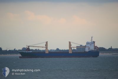
CLI PRIDE
General Cargo
Current Trip
| Time Travelled | 3 days |
|---|---|
| Remaining Time | --- |
| Distance Travelled | 807.37 nm |
| Remaining Distance | --- |
| AVG Speed | 10.9 Knop |
| MAX Speed | 16.7 Knop |
| AVG Wind | 8.5 knots |
| MAX Wind | 24 knots |
| MIN Temp | -15.7°C / 3.74°F |
| MAX Temp | 1.1°C / 33.98°F |
| Djupgående | 6.5 m |
| Position mottagen | 1 d sen |
Current Position
| Longitud | -68.64227° |
|---|---|
| Latitude | 48.59701° |
| Status | Under way using engine |
| Fart | 9.3 Knop |
| Kurs | 55.8° |
| Område | Gulf of St-Lawrence |
| Station | T-AIS |
| Position mottagen | 1 d sen |
Info
Information
The current position of CLI PRIDE is in Gulf of St-Lawrence with coordinates 48.59701° / -68.64227° as reported on 2026-01-07 19:38 by AIS to our vessel tracker app. The vessel's current speed is 9.3 Knop and is heading at the port of LIVERPOOL. The estimated time of arrival as calculated by MyShipTracking vessel tracking app is 2026-01-18 12:00 LT
The vessel CLI PRIDE (IMO: 9513646, MMSI: 305689000) is a General Cargo that was built in 2011 ( 15 År gammal ). It's sailing under the flag of [AG] Antigua Barbuda.
In this page you can find informations about the vessels current position, last detected port calls, and current voyage information. If the vessels is not in coverage by AIS you will find the latest position.
The current position of CLI PRIDE is detected by our AIS receivers and we are not responsible for the reliability of the data. The last position was recorded while the vessel was in Coverage by the Ais receivers of our vessel tracking app.
The current draught of CLI PRIDE as reported by AIS is 6.5 meters
Weather
| Temperature | 1.2°C / 34.16°F |
|---|---|
| Wind Speed | 19 knots |
| Direction | 322° NW |
| Pressure | 1023 hPa |
| Humidity | 82.7 % |
| Cloud Coverage | 88 % |
Featured Company
Last Port Calls
Most Visited Ports (Last year)
| Port | Arrivals | |
|---|---|---|
| 10 | ||
| 8 | ||
| 6 | ||
| 3 | ||
| 1 | ||
| 1 |
Last Trips
| Origin | Departure | Destination | Arrival | Distance | |
|---|---|---|---|---|---|
| 2025-12-18 04:35 | 2026-01-04 13:37 | 3565.42 nm | |||
| 2025-12-14 00:36 | 2025-12-17 17:07 | 746.91 nm | |||
| 2025-11-24 19:43 | 2025-12-12 12:35 | 4265.87 nm | |||
| 2025-11-05 19:09 | 2025-11-23 07:56 | 3552.35 nm | |||
| 2025-10-29 21:27 | 2025-11-05 04:22 | 677.09 nm |
Events
| Tid | Event | Detaljer | Position / Dest | Information |
|---|---|---|---|---|
| 2026-01-08 07:38 | STOPPAR förflyttning |
49.39364 / -65.78836
GBLIV
|
Fart: 0.3 kn Kurs: 95° |
|
| 2026-01-07 23:28 | STARTAR förflyttning | 15.35 nm, West of MATANE |
48.90236 / -67.95400
GBLIV
|
Fart: 8.8 kn Kurs: 25° |
| 2026-01-07 23:10 | STOPPAR förflyttning | 15.16 nm, West of MATANE |
48.89700 / -67.95097
GBLIV
|
Fart: 0.2 kn Kurs: 56° |
| 2026-01-07 19:49 | Status ändrad | Default Under way using engine |
48.61245 / -68.60847
GBLIV
|
Fart: 9.3 kn Kurs: 55.8° |
| 2026-01-07 19:38 | UTANFÖR täckningsområde |
48.59701 / -68.64227
Gulf of St-Lawrence
GBLIV
|
Fart: 9.3 kn Kurs: 55.8° |
|
| 2026-01-07 19:34 | Status ändrad | Under way using engine Default |
48.58989 / -68.65774
GBLIV
|
Fart: 8.9 kn Kurs: 56° |
| 2026-01-07 19:18 | Status ändrad | Default Under way using engine |
48.56774 / -68.70837
GBLIV
|
Fart: 9.6 kn Kurs: 57.5° |
| 2026-01-07 19:12 | Status ändrad | Under way using engine Default |
48.55892 / -68.72918
GBLIV
|
Fart: 9.5 kn Kurs: 57° |
| 2026-01-07 18:53 | I täckningsområde |
48.55892 / -68.72918
Gulf of St-Lawrence
GBLIV
|
Fart: 9.6 kn Kurs: 57.5° |
|
| 2026-01-07 07:38 | UTANFÖR täckningsområde |
47.16694 / -70.65021
Gulf of St-Lawrence
GBLIV
|
Fart: 12.3 kn Kurs: 37.4° |