
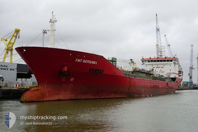
FMT BERGAMA
Oil/Chemical Tanker
Current Trip
| Trip Time | 12 h, 21 mins |
|---|---|
| Trip Distance | 130.98 nm |
| AVG Speed | 10.5 Knop |
| MAX Speed | 11.9 Knop |
| Djupgående | 7.1 m |
| AVG Wind | 2 knots |
| MAX Wind | 3.6 knots |
| MIN Temp | 8.6°C / 47.48°F |
| MAX Temp | 10.9°C / 51.62°F |
| Position mottagen | 20 h, 0 m sen |
Current Position
| Longitud | 12.96356° |
|---|---|
| Latitude | 44.44911° |
| Status | Under way using engine |
| Fart | 11.4 Knop |
| Kurs | 263.5° |
| Område | Adriatic Sea |
| Station | T-AIS |
| Position mottagen | 20 h, 0 m sen |
Info
Information
The current position of FMT BERGAMA is in Adriatic Sea with coordinates 44.44911° / 12.96356° as reported on 2025-02-10 23:09 by AIS to our vessel tracker app. The vessel's current speed is 11.4 Knop and is currently inside the port of RAVENNA.
The vessel FMT BERGAMA (IMO: 9427988, MMSI: 248058000) is a Oil/Chemical Tanker that was built in 2009 ( 16 År gammal ). It's sailing under the flag of [MT] Malta.
In this page you can find informations about the vessels current position, last detected port calls, and current voyage information. If the vessels is not in coverage by AIS you will find the latest position.
The current position of FMT BERGAMA is detected by our AIS receivers and we are not responsible for the reliability of the data. The last position was recorded while the vessel was in Coverage by the Ais receivers of our vessel tracking app.
The current draught of FMT BERGAMA as reported by AIS is 7.1 meters
Weather
| Temperature | 9.6°C / 49.28°F |
|---|---|
| Wind Speed | 8 knots |
| Direction | 118° ESE |
| Pressure | 1023.5 hPa |
| Humidity | 91.6 % |
| Cloud Coverage | 100 % |
Featured Company
Events
| Tid | Event | Detaljer | Position / Dest | Information |
|---|---|---|---|---|
| 2025-02-11 02:42 | STOPPAR förflyttning |
44.49089 / 12.27012
[IT] RAVENNA
|
Fart: 0.3 kn Kurs: 84° |
|
| 2025-02-11 02:11 | ANLÄNDER HAMN |
|
44.49451 / 12.29539
[IT] RAVENNA
|
Fart: 8.5 kn Kurs: 249° |
| 2025-02-10 23:17 | Status ändrad | Default Under way using engine |
44.44606 / 12.93122
ITRAN
|
Fart: 11.4 kn Kurs: 263.5° |
| 2025-02-10 23:09 | Status ändrad | Under way using engine Default |
44.44911 / 12.96356
ITRAN
|
Fart: 11.4 kn Kurs: 259° |
| 2025-02-10 23:09 | UTANFÖR täckningsområde |
44.44911 / 12.96356
Adriatic Sea
ITRAN
|
Fart: 11.4 kn Kurs: 263.5° |
|
| 2025-02-10 22:52 | Status ändrad | Default Under way using engine |
44.45610 / 13.03830
ITRAN
|
Fart: 11.4 kn Kurs: 259.4° |
| 2025-02-10 22:12 | Status ändrad | Under way using engine Default |
44.54948 / 13.06486
ITRAN
|
Fart: 11.9 kn Kurs: 161° |
| 2025-02-10 21:23 | Status ändrad | Default Under way using engine |
44.69823 / 12.98819
ITRAN
|
Fart: 11.8 kn Kurs: 166° |
| 2025-02-10 19:34 | Byter havsområde | Italian part of the Adriatic Sea Croatian part of the Adriatic Sea |
45.02799 / 13.05867
Adriatic Sea
ITRAN
|
Fart: 11.5 kn Kurs: 180.7° |
| 2025-02-10 18:43 | Byter havsområde | Croatian part of the Adriatic Sea Italian part of the Adriatic Sea |
45.18319 / 13.01659
Adriatic Sea
ITRAN
|
Fart: 11.4 kn Kurs: 147.7° |