
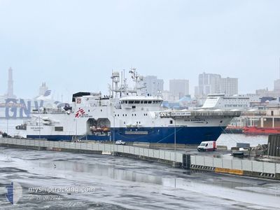
GEO BARENTS
Research/Survey Vessel
Current Trip
| Trip Time | 5 days |
|---|---|
| Trip Distance | 875.76 nm |
| AVG Speed | 8.1 Knop |
| MAX Speed | 8.9 Knop |
| Djupgående | 8.5 m |
| AVG Wind | 10.4 knots |
| MAX Wind | 22.2 knots |
| MIN Temp | 13°C / 55.4°F |
| MAX Temp | 16.2°C / 61.16°F |
| Position mottagen | 1 m sen |
Current Position
| Longitud | -4.41457° |
|---|---|
| Latitude | 36.71086° |
| Status | Moored |
| Fart | |
| Kurs | 341° |
| Område | Alboran Sea |
| Station | T-AIS |
| Position mottagen | 1 m sen |
Info
Information
The current position of GEO BARENTS is in Alboran Sea with coordinates 36.71086° / -4.41457° as reported on 2025-02-08 00:54 by AIS to our vessel tracker app. The vessel's current speed is 0 Knop and is currently inside the port of MALAGA.
The vessel GEO BARENTS (IMO: 9252503, MMSI: 258826000) is a Research/Survey Vessel that was built in 2007 ( 18 År gammal ). It's sailing under the flag of [NO] Norway.
In this page you can find informations about the vessels current position, last detected port calls, and current voyage information. If the vessels is not in coverage by AIS you will find the latest position.
The current position of GEO BARENTS is detected by our AIS receivers and we are not responsible for the reliability of the data. The last position was recorded while the vessel was in Coverage by the Ais receivers of our vessel tracking app.
The current draught of GEO BARENTS as reported by AIS is 8.5 meters
Weather
| Temperature | 11.8°C / 53.24°F |
|---|---|
| Wind Speed | 3 knots |
| Direction | 315° NW |
| Pressure | 1021.3 hPa |
| Humidity | 74.2 % |
| Cloud Coverage | 88 % |
Featured Company
Events
| Tid | Event | Detaljer | Position / Dest | Information |
|---|---|---|---|---|
| 2025-02-01 00:08 | ETA ändrat | 2026/01/29 18:00 2025/01/29 18:00 |
36.71150 / -4.42209
[ES] MALAGA
|
Fart: Kurs: 73° |
| 2025-01-29 19:27 | Status ändrad | Moored Under way using engine |
36.71150 / -4.42211
[ES] MALAGA
|
Fart: Kurs: 73° |
| 2025-01-29 17:54 | STOPPAR förflyttning |
36.71300 / -4.41941
[ES] MALAGA
|
Fart: 0.3 kn Kurs: 226° |
|
| 2025-01-29 17:42 | ANLÄNDER HAMN |
|
36.69923 / -4.41674
[ES] MALAGA
|
Fart: 7.9 kn Kurs: 3.7° |
| 2025-01-29 12:32 | Destination ändrad | ES AGP ES ALG |
36.47050 / -3.58752
ES AGP
|
Fart: 8.5 kn Kurs: 285° |
| 2025-01-29 12:32 | ETA ändrat | 2025/01/29 18:00 2025/01/29 07:00 |
36.47050 / -3.58752
ES AGP
|
Fart: 8.5 kn Kurs: 285° |
| 2025-01-29 11:27 | Upptäckt i hav | Spanish part of the Alboran Sea |
36.42643 / -3.40853
Alboran Sea
ES ALG
|
Fart: 8 kn Kurs: 286.2° |
| 2025-01-29 11:27 | I täckningsområde |
36.42643 / -3.40853
Alboran Sea
ES ALG
|
Fart: 8 kn Kurs: 286.2° |